Orphéon is a real-time RTK Full GNSS precision augmentation GPS correction system allowing users to position themselves with centimeter precision in the national reference anywhere in France and the West Indies with a single GNSS receiver:

Provide RTK GPS corrections

The Orphéon network is made up of nearly 220 observation stations, spread over the entire territory of metropolitan France and the West Indies. All of our stations form a large balanced RTK network that allows us to deliver centimeter RTK corrections to our many customers to increase the accuracy of their precision GPS. Our various services are marketed in the form of subscriptions or hourly packages.

Accuracy and availability

Thanks to its precision and the availability of its RTK GPS corrections, the Orpheon network offers increased productivity to all of its users in the fields of topography, construction, 3D digitization, machine control, precision agriculture and bathymetry, but also for new applications concerning autonomous vehicles, drones (UAV) and connected objects (IOT and M2M). Géodata Diffusion continues to develop the quality of its services through personalized support, responsive technical assistance and continuous improvement of its infrastructures. Our objective is to offer customers a secure and innovative service, guaranteeing them a high and constant utilization rate wherever they are, throughout the territory.

GPS Accuracy

The natural position provided by a GPS alone, gives a good idea of ​​where it is within a few meters, but is not precise enough to allow precision work. It requires correction so that its precision is increased and usable in agricultural work, topography, machine guidance or in many other fields of application (see).

Bathymetric measurements and missions

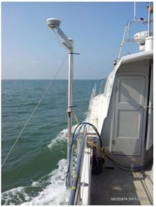
By coupling your measuring instruments (echo-sounder, scanner, sonar, magnetometer, sensors) to a GNSS receiver, it is thus possible to geo-reference your measurements. By adding an inertial unit, it is possible to compensate for the movement of the boat to obtain even more precise results. These same corrections, provided in real time by the Orphéon network, also facilitate the processing of data or images. The professional reports generated are also of better quality for all your business applications:
    • Bathymetry and topography
    • Hydrography
    • Inspection and auscultation of water structures
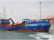
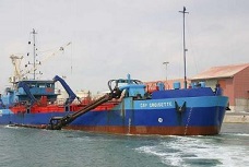
    • Monitoring of dredging and port developments
    • Monitoring over time of the morphology of banks and deposits
    • 3D modeling in and out of water
    • Acoustic imaging
    • Recognition of sedimentary facies
    • Diagnosis of backgrounds and obstacles
    • Study and construction of facilities (ports, banks, etc.)
    • Current, swell, tide measurement
    • Physico-chemical analyzes (conductivity, temperature, PH, oxygen, turbidity, chlorophyll)

Waterways

In addition to the development of river transport, the versatility of water uses and the diversity of professions, the management of waterways and infrastructures reveals a naturally ecological dimension adapted to national economic needs.
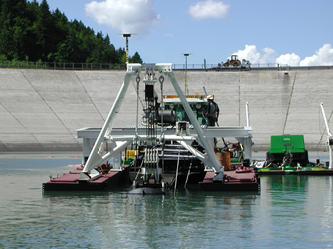
Water reservoirs

Whether it’s hydroelectric developments or reservoirs dedicated to other uses such as agriculture, their significant land footprint and the potential risks they may represent. For the study, the development, the maintenance, the follow-up of the deposits but also the follow-up of the catchment areas upstream and downstream or even the monitoring of the phenomenon of aging of the works of art, the follow-up of aging. Depending on the nature, structure and classification of the structures concerned, various monitoring programs are put in place; either by regular inspection visits, or by the installation of permanent monitoring means.

Port Management

The management of a port requires precise and adapted solutions for: the study, the construction, the development, the maintenance, the positioning and the navigation aid.
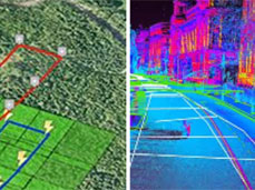
Bathymetry

Underwater equivalent to hypsometry or terrestrial topography. Bathymetric, or hydrographic, measurements establish maps that are generally produced to aid in the safety of surface or underwater navigation, and usually show underwater features, such as an ocean trench, or terrain such as contour lines (called depth contours or isobaths) and selected depths (soundings), and usually also to provide surface information for coastal navigation.

Oceanography

Oceanography, in the sense of the study of the coastal and offshore marine environment, aims to know the dynamics of the oceans, as well as the physico-chemical and environmental parameters governing this environment. The quality of the means of observation is therefore essential to carry out these studies on the entire water column: remote sensing, fixed measurement stations, on buoys or boats to better understand the functioning of the ocean-atmosphere, climate change, changes in the water cycle or sea level.

Renewable energies, offshore, oil & gas

Determine the nature of the funds, the potential obstacles to an infrastructure installation but also a continuous monitoring to observe the environmental impact, the state of the submerged installations.

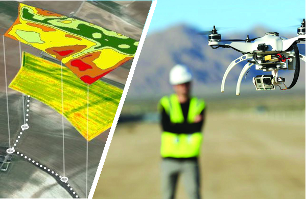
Choosing a software solution

Depending on your business applications (Territory Analysis, Infrastructure Inspection, Surveillance), it will be necessary to control all of your sensors to store and process all of this information. This dedicated software and specifically adapted to these issues, will allow you to significantly save calculation time on your complex projects (digital dense surface models MNS, digital terrain models DTM, detection of changes etc.) Our distributors are at your disposal to support you and offer you the solution best suited to your needs, do not hesitate to contact them.

Orpheon subscriptions

The Premium Orpheon offer These subscriptions give access to unlimited Real-Time correction services in the NRTK Full GNSS centimetric repeatable GPS + Glonass + Galileo + BeiDou network.

Hourly Packages

The non-binding offer This is access to the N-RTK GNSS correction network with real-time centimeter accuracy (GPS, Glonass). Often used to discover our services.

Online post-processing and RINEX files from the Orpheon network

The 3D control offer This is access to the N-RTK Full GNSS correction network with centimeter precision (GPS, Glonass, Galileo, Beidou). Often used to control the accuracy of its measurements or even for areas where a mobile internet connection is not available for real time.

Benefits

In your professional practice you can count on the knowledge, the know-how and the centimetric precision of the Orphéon network to meet your missions and your obligations. The network has been thought out and designed according to the rules of the art, it is constantly monitored and checked regularly. (The network-Orpheon). Everything has been thought out to allow you to benefit from increased productivity.
With the Orphéon network, you work with identical precision throughout the territory thanks to a uniform distribution of stations in metropolitan France and the West Indies. Whatever your position, the distance from the nearest reference station is never more than 30 km.

100% Galileo and BeiDou correction services in addition to GPS and GLONASS:

  • more satellites (+22 Galileo)
  • faster fixing,
  • more measurement stability,
  • more availability,
  • better positioning
  • fewer multipaths
Choose your area of ​​coverage and your duration of commitment according to your real need for an adapted price and discounts
RTK precision positioning geo-references your measurements or photogrammetry images in one step in real time to save production time. Or even as a control tool thanks to the post-processing available online.
A regular mesh and a reinforced infrastructure for you to secure data transfer, for greater reliability and repeatability on a daily basis.
The availability of the service gives the possibility to work from day to night, in foggy weather etc. by focusing their attention on the GPS guidance tool and no longer on driving for an always impeccable result