Orphéon is a real-time RTK Full GNSS precision augmentation GPS correction system allowing users to position themselves with centimeter precision in the national reference anywhere in France and the West Indies with a single GNSS receiver:

Provide RTK GPS corrections

The Orphéon network is made up of nearly 220 observation stations, spread over the entire territory of metropolitan France and the West Indies. All of our stations form a large balanced RTK network that allows us to deliver centimeter RTK corrections to our many customers to increase the accuracy of their precision GPS. Our various services are marketed in the form of subscriptions or hourly packages.

Accuracy and availability

Thanks to its precision and the availability of its RTK GPS corrections, the Orpheon network offers increased productivity to all of its users in the fields of topography, construction, 3D digitization, machine control, precision agriculture and bathymetry, but also for new applications concerning autonomous vehicles, drones (UAV) and connected objects (IOT and M2M). Géodata Diffusion continues to develop the quality of its services through personalized support, responsive technical assistance and continuous improvement of its infrastructures. Our objective is to offer customers a secure and innovative service, guaranteeing them a high and constant utilization rate wherever they are, throughout the territory.

GPS Accuracy

The natural position provided by a GPS alone, gives a good idea of ​​where it is within a few meters, but is not precise enough to allow precision work. It requires correction so that its precision is increased and usable in agricultural work, topography, machine guidance or in many other fields of application (see).

A Geographic Information System (GIS)

Makes it possible to exploit different information having a spatial location or an address. Thus this Geographic Information System allows you to collect and visualize in the form of structured layers all the information you need and to sort the ones that are really useful to you.

The more precise and relevant the positioning, the more the relationships between the information then appear obvious, bringing them sometimes unsuspected added value.

It is from data of sometimes very diverse origins, dealing with different themes that it will be possible thanks to a GIS to produce relevant information that sheds new light on the subject treated. Terrain surveys using GPS RTK naturally find their place there.

GIS software gives you all the modern tools to create maps, integrate information, visualize scenarios, solve complex problems, effectively present your ideas and implement effective solutions like never before.

To power their GIS solution, organizations of all sizes, schools, governments and companies use and trust the precision geolocation of the Orphéon network on a daily basis.

For your assignments

Ideal for any precision mapping project, the Orpheon network allows you to acquire, collect, orient, measure or analyze and format all your geo-referenced data with precision.

Whether the collection is done in the field with real-time RTK corrections on your handheld or geospatial imagery equipment, raw data without corrections can also be saved for accurate post-processing.

The Orphéon network offers you the best solutions to support you in all stages of asset management, the collection of geo-referenced data and any precision geo-positioning application used in the fields:

    • Architecture
    • Construction, Construction
    • Network management or implementation
    • Urban heritage management
    • Archeology
    • Geology
    • Forest
    • Agronomy
    • Precision farming
    • police work

Connecting to a real-time positioning accuracy augmentation GNSS network is changing the way GIS users gather and manage geographic data acquisition on a daily basis.

The choice of a crucial software solution

One of the main challenges in managing spatial data stems from the fact that the data resides in different databases and in different formats. The different departments, within your structure as well as the other organizations with which you work, manage their data with different solutions or software. You need to be able to access this data, no matter where it lives and what format it’s stored in or how often it changes, and be able to integrate it into your work or easily share it. Our distributors are at your disposal to support you and offer you the solution best suited to your needs, do not hesitate to contact them.

La gestion des données

The interfaces or various existing software, easy to use, allow viewing, modifying and exporting all the information collected in the field, but also transferring this data directly to the office, where the consistency and validity of the data can be checked to you avoid multiple trips. The coupling of this positioning data can also be shared with other equipment also using precision GPS and RTK corrections. Thus this data can be used or come from:
  • compact portable equipment with or without an external antenna.
  • drones equipped with GPS, for cubature calculation work or crop or soil analysis, for example.

With your augmented reality applications

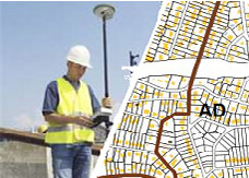
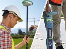
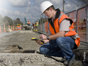
Augmented reality in the field is gaining precision and stability. Developers are now using a precision GPS connected to their tablet and the RTK signal from the Orpheon network to display a 3D model directly at the place of use or construction at 1:1 scale.

null

Augmented reality more precise and stable thanks to centimetric corrections

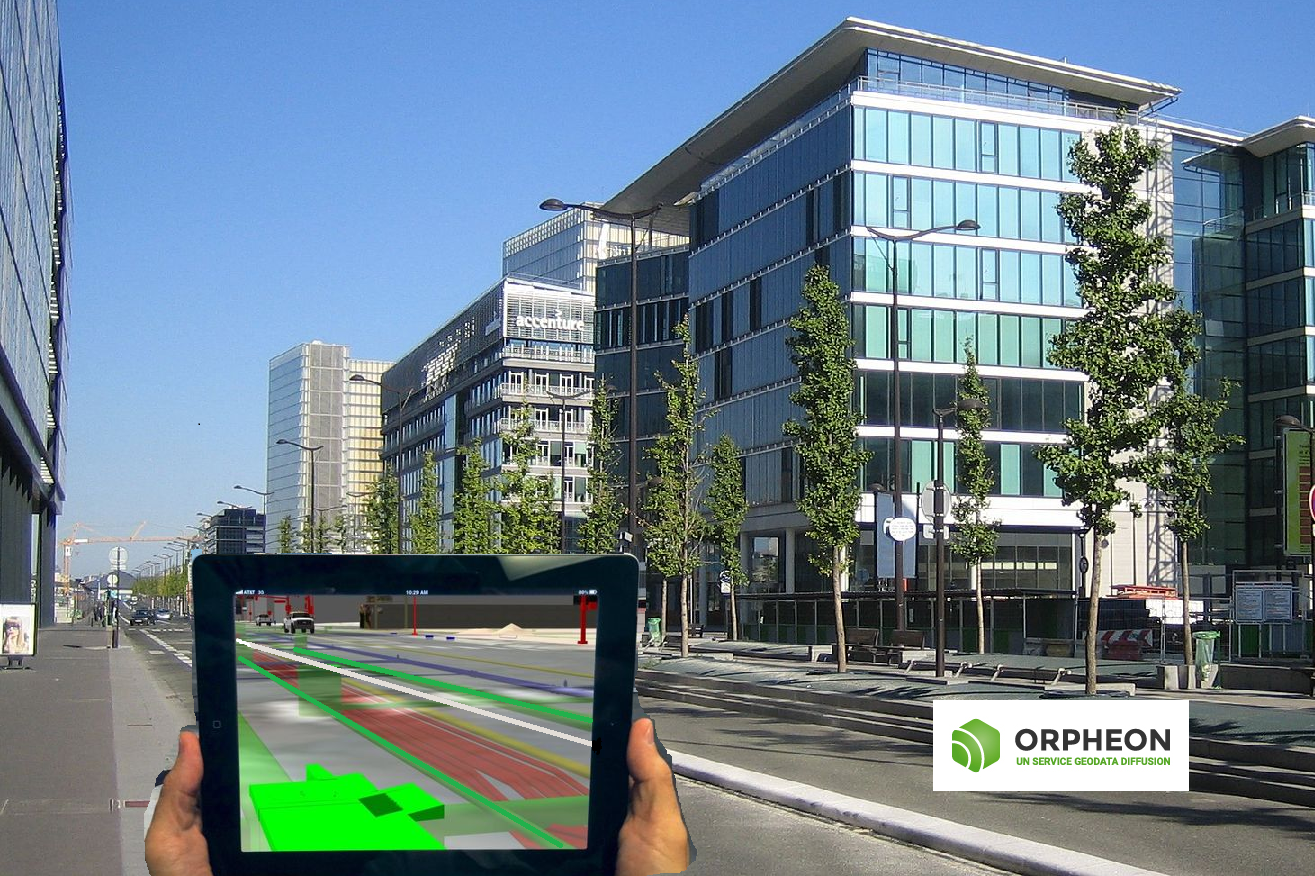
This augmented reality is integrated directly into the images captured by the tablet’s integrated camera, live and allows excellent immersion which multiplies the projection capacity of field professionals or investors by putting them face to face with the various invisible underground elements such as buried networks or projecting their projects into reality. Augmented reality gives them a good overview of the integration of projects within existing architecture or of the constraints of the close environment by showing what is difficult, if not impossible, to move. In addition, it is possible to interact from the screen on the projected 3D model and to take advantage of many features integrated into these applications, which also offer a wealth of additional information, judicious notes and many other contents that enrich the project.

In industry too, augmented reality is becoming an excellent way to promote a project: factory, production line, products.

Orpheon brings precision and stability

The centimetric precision provided by the use of a precision GPS associated with the RTK correction signal from the Orpheon network then becomes essential and greatly facilitates the tasks of developers. Objects integrated in augmented reality are thus very quickly and correctly placed in the projected space without oscillation.

null

A Full GNSS network: one step ahead

Our customers connect to our NRTK real-time corrections services with their GNSS-compatible equipment and take full advantage of the new Galileo and BeiDou corrections in addition to traditional GPS and Glonass. The addition of these very many additional satellites brings more precision and availability even in the most difficult conditions of use..  (voir article 22 Operational Galileo Satellites accessible with the Orpheon network) null

Democratization of technology

The arrival of high-performance and rugged tablets or smartphones with increased autonomy, but also the democratization of precision GPS favors the emergence of many projects to which the Orphéon network responds perfectly.

Orpheon subscriptions

The Premium Orpheon offer These subscriptions give access to unlimited Real-Time correction services in the NRTK Full GNSS centimetric repeatable GPS + Glonass + Galileo + BeiDou network.

Hourly Packages

The non-binding offer This is access to the N-RTK GNSS correction network with real-time centimeter accuracy (GPS, Glonass). Often used to discover our services.

Online post-processing and RINEX files from the Orpheon network

The 3D control offer This is access to the N-RTK Full GNSS correction network with centimeter precision (GPS, Glonass, Galileo, Beidou). Often used to control the accuracy of its measurements or even for areas where a mobile internet connection is not available for real time.

Benefits

In your professional practice you can count on the knowledge, the know-how and the centimetric precision of the Orphéon network to meet your missions and your obligations. The network has been thought out and designed according to the rules of the art, it is constantly monitored and checked regularly. (The network-Orpheon). Everything has been thought out to allow you to benefit from increased productivity.
With the Orphéon network, you work with identical precision throughout the territory thanks to a uniform distribution of stations in metropolitan France and the West Indies. Whatever your position, the distance from the nearest reference station is never more than 30 km.
The addition of the Galileo and BeiDou satellites to the GPS and GLONASS satellites significantly increases the number of satellites that can be observed simultaneously by a GNSS antenna, thus offering increased positioning quality.
RTK precision positioning allows you to geo-reference your measurements simply and confidently in the national reference system in real time to save production time. Or even as a control tool thanks to the post-processing available online.
Thanks to the mobile internet connection, you are not limited by the range of radio systems and you do not have to deal with questions of frequencies or interference. The time saved allows you to multiply the work and concentrate on your production.
With Orpheon, preparation work is reduced to a minimum and you can start working faster. No pivot deployment to plan or monitor.
Choose your area of ​​coverage and your duration of commitment according to your real need for an adapted price and discounts
RTK precision positioning allows you to geo-reference your measurements simply and confidently in the national reference system in real time to save production time. Or even as a control tool thanks to the post-processing available online.
A regular mesh and a reinforced infrastructure for you to secure data transfer, for greater reliability and repeatability on a daily basis.
The availability of the service gives the possibility to work from day to night, in foggy weather etc. by focusing their attention on the GPS guidance tool and no longer on driving for an always impeccable result