… The best service, plus stability.
 We observe the consequences of the combination of several factors which disrupt GPS positioning and our habits.
Concerning periodic phenomena, they have tended for years to be discreet but today they remind us in a more or less strong way.
It is therefore interesting to understand its origin and what impact it can have on our daily activities.
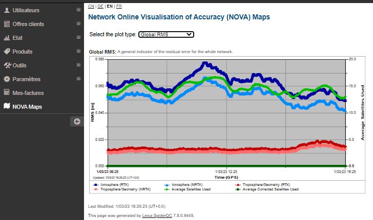
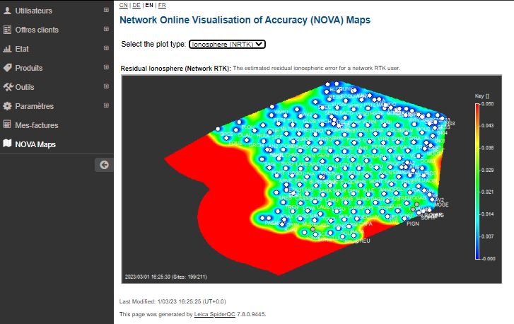
Visualize Ionospheric activity with Orpheon
![]()
It is now possible to view the level of disturbances on your customer area or on the smartphone application for the last 8 hours (NOVA Maps).


Intense solar activity

On October 2, 2013, all satellite networks around the world (GNSS, telecommunications, etc.)
suffered temporary disruptions due to intense solar activity.
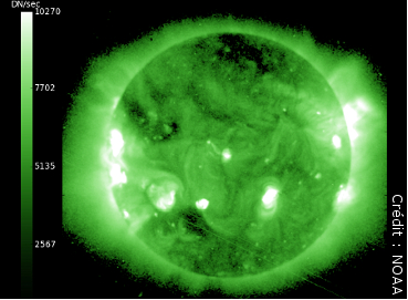
Solar eruption
The Earth can be compared to a magnetic dipole whose field protects the Earth’s atmosphere from energetic particles by deflecting them from their trajectory.
Fluctuations in the number, energy or speed of solar wind particles can cause a variation in the Earth’s magnetic field (orientation and amplitude) and therefore disrupt this magnetic shield system; we talk about geomagnetic disturbance.
The results
The consequences caused by solar phenomena such as eruptions or geomagnetic storms are numerous and varied: accelerated corrosion of pipelines, breakdowns of satellites or electrical networks, etc. Phenomena of solar origin also cause ionospheric disturbances which lead to a degradation of the precision of GNSS applications.
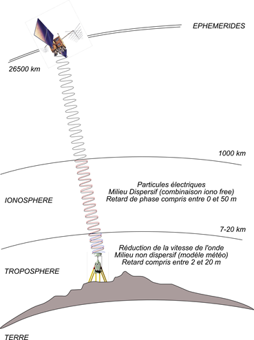
Currently, recent GPS positioning techniques based on the sending of differential corrections by a reference station (such as Real-Time Kinematic or RTK) generally make it possible to obtain precise positioning. of the order of a few centimeters in real time. However, the ionosphere constitutes the main limitation to the accuracy of these positioning methods.
By crossing this atmospheric layer located between 50 and 1000 km altitude loaded with electrical particles under the effect of the ionization of its molecules by solar electromagnetic radiation (ultraviolet), the GNSS signals are refracted, causing a lengthening of their path this which explains the positioning error of a GNSS receiver regardless of the satellite constellations used (GPS, Glonass, Galileo or Beidou).
Regardless of the brand of equipment or the GPS, Glonass, Galileo or Beidou constellations used, no one really escapes it: these phenomena will affect everyone and affect your positioning accuracy to a greater or lesser extent.
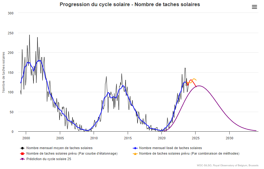
Significant solar activity every 11 years
ISES Solar Cycle Sunspot Number Progression
The cycle of solar activity from 2002 to today
Solar activity follows a periodic cycle of 11.2 years on average
Solar activity goes through a maximum during which its radiation increases and sunspots appear as well as eruptions releasing jets of ionized matter (coronal mass) into space causing geomagnetic storms (Moreton waves) which disrupt radio transmissions. , can disturb the Earth’s magnetic field and damage satellites in high orbit.
2014 – 2025 being maximums of this cycle.
The year 2020 was synonymous with the end of a cycle of decreasing ionospheric disturbances for our applications. We must expect in the future to have to deal with increased solar activity, hence the importance of having a dense network of permanent GNSS stations to properly model this error.
Other factors: Precession and Periodic Nutation 18.6 years
Furthermore, the axis of terrestrial rotation draws a circle on the celestial sphere (Precession). However, this circle is not perfect due to the attraction of the Moon, and to a lesser extent the Sun. Eccentricity is one of the factors adding to these disturbances because when it is maximum, the Earth at perihelion can receive up to 26% more energy from the Sun than at aphelion (also impacting natural climatic variations of the earth – John Imbrie). This periodic oscillation (Nutation) completes a complete cycle in 18.6 years. (Milankovitch cycles).
As you can see from the chart above, the solar activity cycle bottoms out in 2020 and forecasts for solar activity are now on the rise:
As the months passed, the number of sunspots quickly began to exceed predictions for a given month in mid-2020, which then accelerated in early 2021. As of March 2021, the number of sunspots was consistently well greater than the planned quantity, leading to a smoothed average greater than double what was planned.
Arriving in January 2023, NOAA had an average predicted value of 63.4, while the measured value reached 143.6!
Source : Site SpaceWeatherLive.com article du 08.02.2023
par Christian Harris
Daily variations
Over the course of a day, ionospheric activity linked to solar activity is maximum around 12:00 p.m. solar time. So as shown in the graph below, this ionospheric activity was very significant on Wednesday October 2 at noon with I95 index values beyond the limit of 8 indicating very high activity for the targeted applications and therefore impacting all communications satellites during their passage through the ionosphere then rich in charged particles:

The Weather of Disruptions
As you can see on the SpaceWeatherLive.com website which observes Solar Weather, this phenomenon is global with an ionospheric index K (quantification of geomagnetic disturbances). This is an average of the K indices relating to 13 stations located between 44 and 60◦ latitude; it is therefore a global index.

The K index is a local index which characterizes the variation of the magnetic field at the station considered compared to a calm reference day; these measurements are carried out using magnetometers. The Kp index scale includes 10 levels:
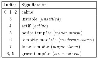
The levels of the Kp Index
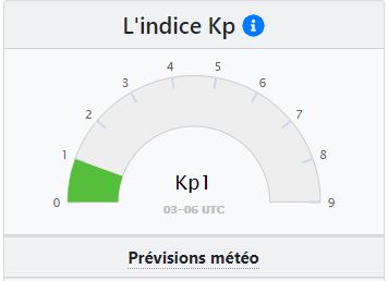
When the Kp index is greater than 5, this corresponds to a geomagnetic storm:

Furthermore, in a completely uncorrelated manner, the distribution of GPS satellites is not optimal in this same time slot with a GDOP exceeding the limit set at 3 as shown below:

As a reminder, the DOP corresponds to a coefficient of weakening of the precision linked to the good distribution of satellites in the sky (calculation of the position of the mobile by spatial multilateration). The GDOP (General Dilution of Precision), ideally equal to 1, should not exceed 2 or 3 for precision positioning applications.
Beyond the notion of DOP, it is also necessary to have a minimum of 5 visible satellites beyond the fact that they are well distributed, which can prove complicated at this time of the day, this particular configuration linked to the very nature of GPS orbits advancing by 4 minutes per day:

Finally, as a reminder, GLONASS serves as an augmentation to GPS for the majority of GNSS mobiles, you need a minimum of GPS satellites (at least 4) well distributed to be able to work in GPS+GLONASS.
Predict the state of constellations on your construction sites
By following the following link, you will find a tool allowing you to visualize and predict the state of the constellations on your construction sites : http://www.gnssplanningonline.com/#/Settings
The impact on your connection
As you will have understood on this subject, if you have problems in the middle of the day (abnormally long time to fix the entire ambiguities or impossibility of fixing them in clear environments, repeated passages while floating even though you receive many corrections etc. .), check the number and distribution of GPS satellites and check the ionospheric activity via the site: http://gpsweather.meteo.be/geomagnetism/ground_K_dourbes.


