Need corrections to get the centimeter
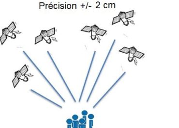
A standard GPS gives an approximate natural position with an accuracy of a few meters. This precision, which is sufficient for many consumer applications, can be corrected to obtain much better precision and make this technology usable by professionals for their precision work.
Corrections to gain precision
For its accuracy to be increased and usable in agricultural work, surveying, machine guidance or in many other fields of application (see) It requires corrections.
GPS will have to integrate additional data into their positioning calculations in order to correct the various errors related to this technology.
The correction data are obtained from fixed GPS (reference station) placed on positions whose coordinates are perfectly known. It is thus possible to quantify the different errors and correct them in order to then be able to share them with other GPS located in the same conditions (nearby).
Precision GPS
We distinguish two types of GNSS receivers:
-
-
-
- Consumer receivers (Watches, telephones, tablets, cars etc…) which will work only in natural mode without the possibility of improving their precision thanks to corrections
- Precision receivers, which will be able to integrate external correction data allowing them to increase their precision.
-
-
Access to corrections
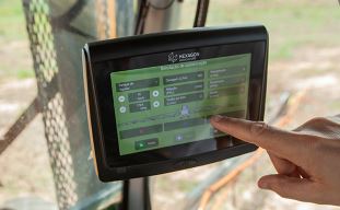
To access the corrections, the precision GPS must have mobile internet access. After identifying itself on the server and giving its initial position, the GPS will receive a data stream every second containing the correction parameters to be integrated into its positioning calculation. Within moments, the GPS will converge to centimeter accuracy.
For more than 15 years, the Orpheon network has offered real-time RTK Full GNSS precision increase GPS correction services allowing users, using a single GNSS sensor, to position themselves with centimeter precision in the national reference anywhere in France and in the West Indies.
RTK
RTK (Real Time Kinematic) is the device used to transmit correction data from an observation base to mobile GPS in real time.
The mobile will then integrate the information from this observation station (mono-station) in its positioning calculation to gain precision.
The NRTK (Network Real Time Kinematic) comes from the use of several observation bases to optimize and model the correction information on the covered area (which makes the great strength of the Orpheon network compared to single-station installations )
The data from this network of observation stations is collected in real time on a centralized server. Mobiles connect to the server via mobile internet to get their corrections information.
Observation stations
Orphéon is the first French multi-constellation network in France.
With its 220 stations in mainland France, all Full GNSS: GPS, GLONASS, Galileo and BeiDou with a historical presence in the French West Indies.
All of our stations form a large balanced RTK network that allows us to deliver centimetric GNSS corrections to our many customers to increase the accuracy of their precision GPS.
Our various services are marketed in the form of subscriptions or hourly packages.
Click on the map to access the interactive network map
The Orphéon satellite positioning correction system is based on a network of observation reference stations (OSR: Observation Space Representation) spread over the territory, each position of which is known with precision.
All the observations of this network are concentrated on a computing center to deliver to each user corrections allowing him to obtain a much more precise positioning.
OSR services offer positioning accuracy to the nearest centimeter, within the network or within 30 km of the nearest reference station (in single station mode).
A very regular presence, without compromise and without equivalent in France.
The careful choice of layout for each of our 215 reference stations creates a linear and regular geometric mesh. Territory coverage is uniform wherever you are.
A regular and homogeneous layout
With the Orphéon network, you work with identical precision throughout the territory thanks to a uniform distribution of stations over all the areas covered, whatever your position, the distance from the nearest reference station is never more than 30 km.
You receive corrections from a combination of multiple stations for greater stability and accuracy. There is only one hardware configuration to connect to the network anywhere in France, it is our server which is responsible for automatically establishing the cell of observation stations that suits you.
The Orphéon network thus stands out significantly from its competitors who are multiplying the number of reference stations because of their disorderly location on the territory and whose coverage is losing homogeneity, sometimes leaving very large distances in the meshes of their network.
Reinforced coverage
This coverage is reinforced at the borders thanks to the sharing of reference stations of our international Hxgn SmartNet network with:
-
-
-
-
- Belgium
- Luxembourg
- Germany
- Switzerland
- Italy
- Spain
-
-
-
High quality centimetric positioning
Based on L1, L2 and L5 frequencies emitted by satellites to make positioning more resistant to interference and signal reflections, especially in an urban environment.
Concretely, the initialization time and the delay to fix or convergence are significantly reduced as well as the repositioning times in the event of disconnection. The use of multiple frequencies allows better rejection of repair signals, which makes it possible to process a maximum of direct signals, which provides greater precision and greater positioning repeatability.
Positioning accuracy with Orphéon is centimetric for a standard deviation of 1σ:
-
-
-
-
- between 1 and 2 centimeters in planimetry (Lambert 93).,
- between 2 and 3 cm in altimetry (IGN69).
-
-
-

Technically:
The fact of working in a network makes it possible to obtain, in a few seconds, a homogeneous precision on all the zones covered, whatever the distance separating the mobile from the nearest station. The system is compatible with the vast majority of mobile receivers on the market insofar as the corrections are broadcast in standard formats:
In a standardized format (RTCM3) or in well-defined proprietary formats (CMR/CMR+, MAX, iMAX, LB2)
Following well-defined and standardized (MAC) network computing concepts.
Full GNSS network and services
The infrastructure and the calculation software allow us to deliver positioning corrections for the different GNSS constellations:
100% more satellites
The addition of the Galileo and BeiDou satellites to the GPS and GLONASS satellites now makes it possible to double the number of satellites that can be observed simultaneously by a GNSS antenna.
The addition of the GALILEO and BeiDou constellations thanks to the Orphéon network is not a simple gadget, but the assurance of better daily productivity in the field.
Indeed, you can now count on the constant availability of at least 20 satellites at all times to bring you real advantages:
Improved positioning quality
-
-
-
-
- More satellites available to calculate its position
- Precise positioning even in difficult environments (urban canyons for example or under a canopy)
- Improved positioning reliability
- Shorter fixing time
- Multi-frequency L1/L2 and L5
-
-
-
Everything has been thought out to allow you to benefit from increased productivity.
GPS receiver
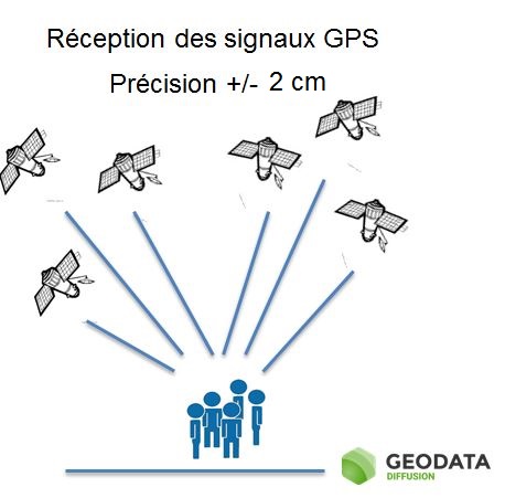
A GPS is a receiver of signals sent by satellites to allow it to calculate its position. In natural mode (without correction) this calculation makes it possible to obtain an accuracy of the order of plus or minus 3 m. To obtain the calculation of a position, the receiver must pick up signals from at least 4 satellites.
To determine the position, the GPS receiver calculates the distance at which the satellites are at the same time from the data of their ephemerides and based on its internal clock, knowing precisely the path that the satellites follow.
Principle of correction:
By placing a fixed GPS Reference Station (or base station) whose exact and precise position is known, we can calculate the positioning error that a GPS returns to us at any time.
It then becomes easy to calculate the correction that gives us its exact position to the nearest centimeter (and sometimes better).
In use, we found that it was possible to apply this same correction to other GPS units that are nearby (a few km).To distribute this correction to the GPS which are in the vicinity, it is necessary to be able to communicate with them, either by radio or by mobile telephone (modem).
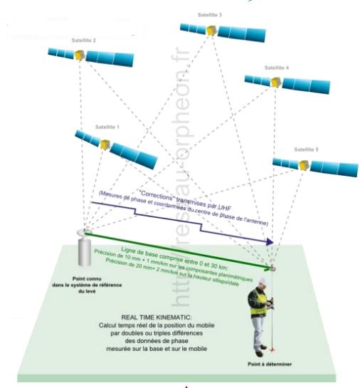
The single Station:
By connecting a mobile GPS to a fixed reference station (or pivot) by radio or mobile telephone, it is possible to take advantage of the corrections and therefore of the centimetric precision calculated by the reference station (RTK mode).
The distance that separates the mobile GPS from the Reference Station becomes the baseline and the accuracy of the correction then becomes dependent on its length. The further away from the base station, the more the accuracy deteriorates. It is observed that within a radius of 30km the centimetric precision is preserved.
This mode is of great interest because it allows a very fast start-up (reduced initialization time) and a moderate investment but remains fragile in the event of a stoppage of the base station.
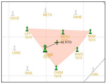
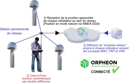
Network mode:
The network mode or NRTK, is an advanced correction calculation mode which implements several reference stations which surround a mobile receiver, thus creating a cell. By combining the individual corrections of each of the reference Stations of the cell, it is then possible to obtain a centimetric correction that is more homogeneous and more stable than with the single station.
This mode, which therefore does not depend on the mobile receiver, then offers a correction which no longer depends on the length of the baseline. The quality of the corrections is uniform everywhere within the cell.
This mode also offers an undeniable advantage because it does not depend on a single base station to generate quality corrections but on a cell and in the event of a stoppage of one of the stations, the network continues to operate correctly and at deliver corrections of centimetric quality and precision.
Very fast start-up and initialization time are reduced. Of course, the network mode represents a major investment because it requires a major infrastructure and great expertise that cannot be improvised.
Repeatability:
In some applications, it is essential to be able to return to exactly reposition oneself in the same place and sometimes after several years. This repeatability is obtained thanks to the centimetric precision of the corrections delivered on the one hand, but also by the precise and fixed positioning of the reference stations. Stability and control of their positioning is one of the keys to repeatability.
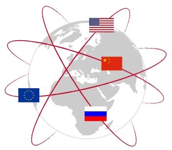
Satellite constellations:
Until today, we used the generic term GPS for Global Positioning System to describe the various geopositioning equipment.
However, this term is actually the name of a set of 24 American satellites placed in orbit at an altitude of 20,000 km. This constellation of satellites, which was the first in history, therefore left its name to geopositioning technology.
GPS + Glonass + Galiléo + Beidou
These satellites revolve around the earth and are therefore in constant motion. To establish a position, a minimum of 5 satellites is required.
Other constellations of satellites have thus been put into service by other countries:
- GPS for US satellites
- Glonass for Russia,
- Galileo for Europe has also been put into service, all are available in France.
- Beidou for China and more recently
All of these constellations are grouped together under the single name of GNSS for Global Navigation Satellite System.
Hardware compatibility
Above all, the receiver must be able to receive and process corrections as an RTK client (which is currently not the case for the majority of smartphones). Different manufacturers, represented by our distributors, offer a wide range of receivers suitable for the various most common applications (see Areas of application). But it is also possible to find many electronic boards or components to integrate for the development of dedicated solutions or for the study and design of new applications.
Not all GNSS receivers are compatible with all satellite constellations available today. Thus the compatibility or the capacity of a receiver to process the signals coming from these different constellations of satellites makes it possible to increase the possibility of working in difficult zones where the masks are numerous because it is nevertheless always necessary a minimum of 4 satellites to establish a position.
The benefits of GNSS
By offering the possibility of mixing the signals of the different constellations of satellites, GNSS receivers make it possible to calculate a more stable position but also to work in more restricted places.
Indeed, buildings, trees, constructions, etc. create masks that prevent receivers from correctly receiving satellite signals. The more a receiver is able to process different signals, the less these masks will prevent you from working: hence increased working comfort and productivity.
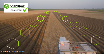
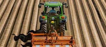
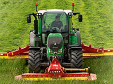
For example in Agriculture, a first application consists in practice in taking advantage of the GPS autoguiding of machines in order to optimize the operations of tillage, sowing, spreading and harvesting by minimizing overlaps of 13% between passages. of the tractor thereby preserving every foot, optimizing machine time, fuel consumption, tool wear and even payroll. Preparation times are also reduced thanks to the elimination of tramlines (approximately one hour for 10 ha). – source Arvalis essentials
As the tractor moves on its own throughout the work being carried out, corrections must be sent to it on a continuous basis. The quality of the work obtained depends on the precision of these corrections, which themselves depend on the various technologies available, but also on the quality of reception of this information.

The precision thus obtained makes it possible to reduce inputs and adjust crop management for an improvement in the environmental impact as part of sustainable agriculture programs, but also to increase savings on your farm. GPS guidance allows you to concentrate on the work of the tool with a repeatable and constant result, thus reducing fatigue. This solution also makes it possible to extend the possible intervention ranges when visibility conditions are reduced.
Other apps
All operations requiring centimeter precision are faster, more efficient, and more economical. From the preparatory study phases, to the construction or development operations and end-of-site control, everything is optimized.
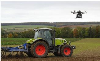
The Orpheon network offers increased productivity to all of its users in the fields of surveying, construction, 3D digitization, machine guidance, precision agriculture and bathymetry, but also for new applications concerning autonomous vehicles, drones (UAV) and connected objects (IOT and M2M).
Coupling is also possible with many other geo-localized information from digital mapping applications serving agriculture (GIS or geographic information system) for the management of a complete agricultural domain (determination of plots or passages , yield maps, intra-plot variation, etc.).

Géodata Diffusion First Full GNSS network in France, offers various possibilities of subscriptions or packages adapted to your present and future needs.
The choice of the type of transmission has a major impact on access to the new possibilities offered by the increasingly widespread Internet applications in precision agriculture.
Network or single-station solution?
The Orphéon network has for many years been supporting an ever-growing number of farmers and demanding professionals who are satisfied with the quality of our services.
For agricultural work, it is interesting to take an interest in the repeatability of the precision delivered by a correction signal for your guidance systems.
The natural position provided by a GPS alone, gives a good idea of where it is within a few meters, but is not precise enough to allow precision work.
The corrections and precision provided by the Orpheon network can also be coupled with many other geo-localized information for the extended management of your operation.
Although Geodata Diffusion is not intended to sell hardware, we would like to give you a brief overview of the different applications.
The Orphéon network supports you in your agricultural work throughout the year, throughout the seasons.
The use of GPS-GNSS receivers, more and more widespread, is subject to some reception constraints related to certain parameters or phenomena that can affect the quality of the signals and therefore the work carried out.