Since October 12, 2017, after a good month of testing, Géodata Diffusion has therefore expanded its service offer by offering real-time Full GNSS NRTK corrections compatible with GPS, GLONASS, Galileo and BeiDou.
Orpheon network delivers GALILEO and BeiDou corrections
Full GNSS
Full GNSS (for Geolocation and Navigation by a Satellite System) is a term that designates positioning equipment or installations capable of using all the satellite constellations available for their calculations.
Different satellites
Until today, we used the generic term GPS for Global Positioning System to describe the various geopositioning equipment.
However, this term is actually the name of a set of 24 American satellites placed in orbit at an altitude of 20,000 km. This constellation of satellites, which was the first in history, therefore left its name to geopositioning technology.
These satellites revolve around the earth and are therefore in constant motion. To establish a position, a minimum of 5 satellites is required.
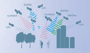
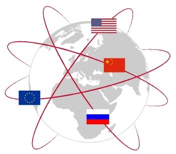
Other constellations of satellites have thus been put into service by other countries:
- GPS from USA,
- Glonass from Russia,
- Beidou from China
- and more recently Galileo from Europe
All these constellations are now available in France.
All of these constellations are grouped together under the single name of GNSS for Global Navigation Satellite System.
GPS Satellites Active in 2019
- GPS: As of August 2019, 74 Global Positioning System navigation satellites had been launched, of which 31 were operational, 9 in reserve, 2 under test, 30 had been retired and 2 had been lost at the time. of the launch. The constellation requires at least 24 operational satellites and the number of official targets is 33.
- Galileo: has 30 satellites (24 operational and 6 in reserve). Galileo began offering early operational service on December 15, 2016, reaching full operational capability in 2019.
- Glonass: As of May 2019, 138 GLONASS navigation satellites had been launched, of which 126 had reached the correct orbit and 24 were currently operational.
- Beidou: BeiDou-3 third-generation BeiDou system will eventually include 35 satellites and is expected to provide global services when completed in 2020.
Extension of Galileo and BeiDou services
All of the reference stations, the infrastructure and the correction calculation software of the Orpheon network have been updated and allow us to deliver NRTK Full GNSS corrections including GPS + GLONASS + Galileo + BeiDou.

Receive Galileo corrections now
Full GNSS services extended to our real-time corrections services, are also available for our online Post-processing and RINEX Download services.
GPS + Glonass + Galiléo + Beidou
What advantages for high precision NRTK?
Since September 7, 2017, all of the Orphéon reference stations, infrastructure and correction calculation software operated by Geodata Diffusion have been able to deliver “Full GNSS” products.
To take advantage of the modernization of the Orphéon network it is important to understand the advantages that the additional Galileo and Beidou signals offer for NRTK positioning.
Through case studies integrating baseline length, multipath and canopy, the results confirm that the Galileo constellation is usable for high precision NRTK positioning purposes and show availability, accuracy, improved reliability and fixation time in harsh viewing environments.
Article published in the XYZ magazine of March 2018
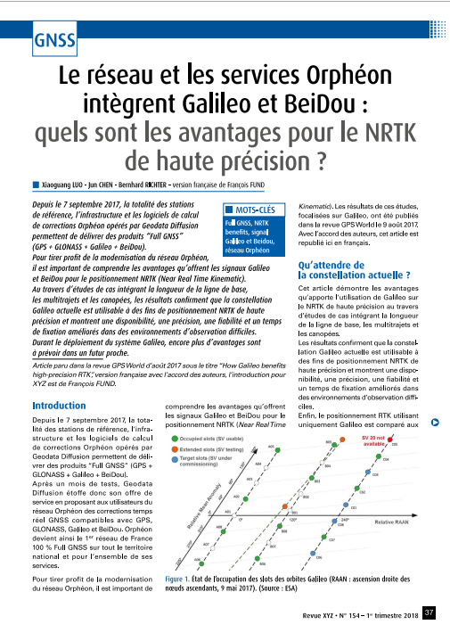
Click on the image to access the article
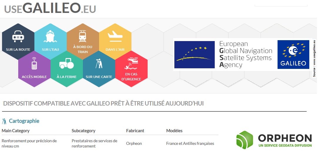
The Orphéon network is referenced on UseGalileo.eu
Directory of devices compatible with Galileo © GSA 2017
Since November 2017
The European GNSS Agency (GSA) supports the EU objective of maximizing the return on investment in Global Navigation Satellite Systems (GNSS) with regard to:
- Benefits for users;
- Economic growth;
- Competitiveness.
Activities
The Agency ensures that Europe achieves its GNSS objectives and that citizens benefit from the European positioning system Galileo.
Its specific tasks are as follows:
- Manage the provision of EGNOS and Galileo services
- Enable the execution of GNSS-based services that meet user needs;
- Improve GNSS services and infrastructure.


Full GNSS for what?
As a reminder, in order to be able to position itself within a few centimeters, a GPS/GNSS rover must be able to:
- perform noise-free phase measurements on at least 5 satellites well distributed in space,
- receive differential corrections on these same 5 satellites.
- increased positioning quality and stability
- productivity gain
Adding the constellations of Glonass, Galileo and BeiDou satellites to those of the GPS constellation thus increases the possibility of receiving a sufficient number of signals of better quality. At the best of the day, up to 11 satellites observed and used: 12 Galileo and 8 Beidou.
Example: reception of 7 Galileo satellites and 4 Beidou – Spider
50% more satellites
The addition of the Galileo and BeiDou satellites to the GPS and GLONASS satellites significantly increases the number of satellites that can be observed simultaneously by a GNSS antenna.
Today, this represents around thirty satellites against the usual twenty, an increase of 50%. Eventually, the number of visible satellites will be around 40, an increase of 100%!
Eventually, the number of visible satellites will be around 40, an increase of 100%!
The arrival and use of the additional GALILEO and BeiDou constellations thanks to the Orpheon network is not a simple gadget, but the assurance of better daily productivity in the field.
Thus, the productivity gains linked to the use of additional satellite constellations can be estimated at +20 to +30% in semi-urban areas or near trees.
Multi-frequency L1/L2 and L5
Based on L1 and L5 frequencies emitted by satellites to make positioning more resistant to interference and signal reflections, especially in an urban environment. Concretely, the initialization time and the delay to fix or convergence are significantly reduced as well as the repositioning times in the event of disconnection. The use of multiple frequencies allows better rejection of repair signals, which makes it possible to process a maximum of direct signals, which provides greater precision and greater positioning repeatability.
Hardware compatibility
Thus the compatibility or the capacity of a receiver to process the signals coming from these different constellations of satellites makes it possible to increase the possibility of working in difficult zones where the masks are numerous because it is nevertheless always necessary a minimum of 5 satellites to establish a position.
Improved positioning quality
- Access even in difficult environments (urban canyons for example or under a canopy)
- Improved positioning reliability (fig 3)
- Shorter fixing time
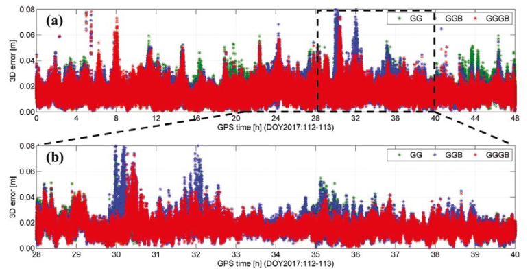
Figure 3: 3D error reduction result of fixed NRTK positions in open-sky
Over the whole period, the integration of Galileo and Beidou provides a stronger positioning repeatability as illustrated in figure 3a above.
Over a 12 hour period, Figure 3b highlights the benefits of Galileo which reduces the 3D error from 6-8 cm to 3-4 cm when two or three Galileo satellites are used in the Full GNSS solution.
The densest and most regular coverage in France
A multi-constellation network
With its 215 stations in mainland France, all Full GNSS: GPS, GLONASS, Galileo and BeiDou with a unique presence in the French West Indies.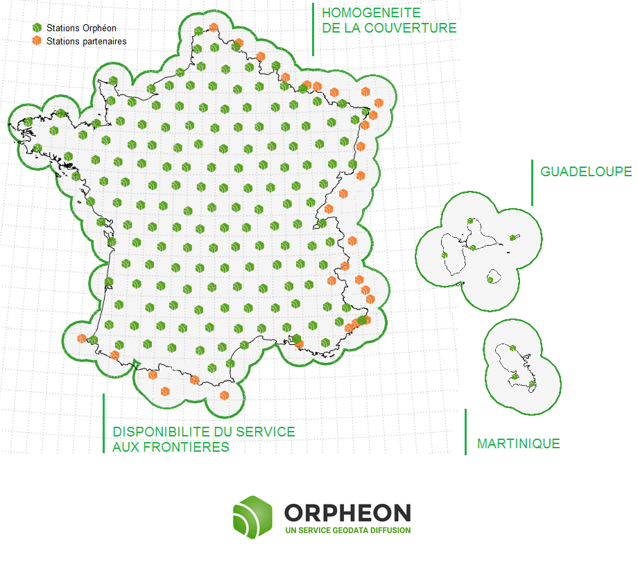
Orphéon is the first French multi-constellation network in France.
How to take advantage of the new Full GNSS services ?
Already subscribed ?
Connect today to our real-time services from your GNSS mobile with your usual user connection parameters (username and password) and select one of our Full GNSS mount points stamped “FULL”.
Settings :
-
-
-
- DNS : ntrip.reseau-orpheon.fr
- Port : 8500
- Mounting point * : VRS_RTCM-MSM_FULL or i-Max_RTCM-MSM_FULL
-
-