Significant solar activity every 11 years
Solar activity follows an eleven-year cycle, with 2015 being a maximum of this cycle. This year 2020 is therefore synonymous with the end of a cycle of reduced ionospheric disturbances for our applications. We must expect in the future to have to deal with increasing solar activity, hence the importance of having a dense network of permanent GNSS stations to properly model this error. As you can see in the graph below, the cycle of solar activity is reaching its minimum and the forecast for this activity is now on the rise:

Disturbances related to geomagnetic storms
As you can see on the SpaceWeatherLive.com website, this phenomenon is global with an ionospheric index K (quantification of geomagnetic disturbances). This is an average of the K indices relating to 13 stations located between 44 and 60◦ latitude; it is therefore an overall index. The K index is a local index which characterizes the variation of the magnetic field at the station considered compared to a calm reference day; these measurements are made using magnetometers. The Kp index scale includes
10 rungs:
The K index is a local index which characterizes the variation of the magnetic field at the station considered compared to a calm reference day; these measurements are made using magnetometers. The Kp index scale includes
10 rungs:
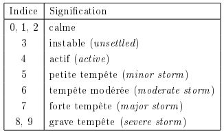
The levels of the Kp Index
The impact on your connection
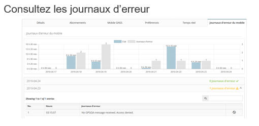
As you will have understood on this subject, if you have problems in the middle of the day (abnormally long time to fix the entire ambiguities or impossibility of fixing them in clear environments, repeated passages while floating even though you receive many corrections, etc. .), check the number and distribution of GPS satellites and check ionospheric activity via the site: http://gpsweather.meteo.be/geomagnetism/ground_K_dourbes.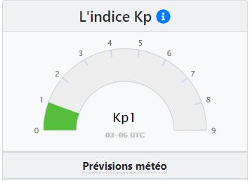
The strength of the Orpheon network
Our network is currently built according to the rules of the art with stations every 60 km, you should not normally be too affected. However, we wanted to pass on the information to you, an informed user is worth two!Tél : 01 69 18 81 60
Fax : 01 69 18 81 61
Mail : contact@geodata-diffusion.fr
Ou accéder au Formulaire de contactAddress :
Géodata Diffusion Immeuble Le Viking – 32, Avenue de la Baltique 91140 Villebon-sur-Yvette – FranceLocate Géodata Diffusion
(Click to open link)Unlimited subscription
Duration :
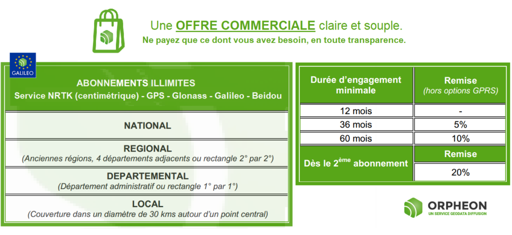
The Subscription contract and its options are entered into for an initial period of at least 12 months depending on the length of commitment taken out by the SUBSCRIBER. Beyond the initial commitment period, the contract continues for an indefinite period. For more information refer to the General Conditions of Sale
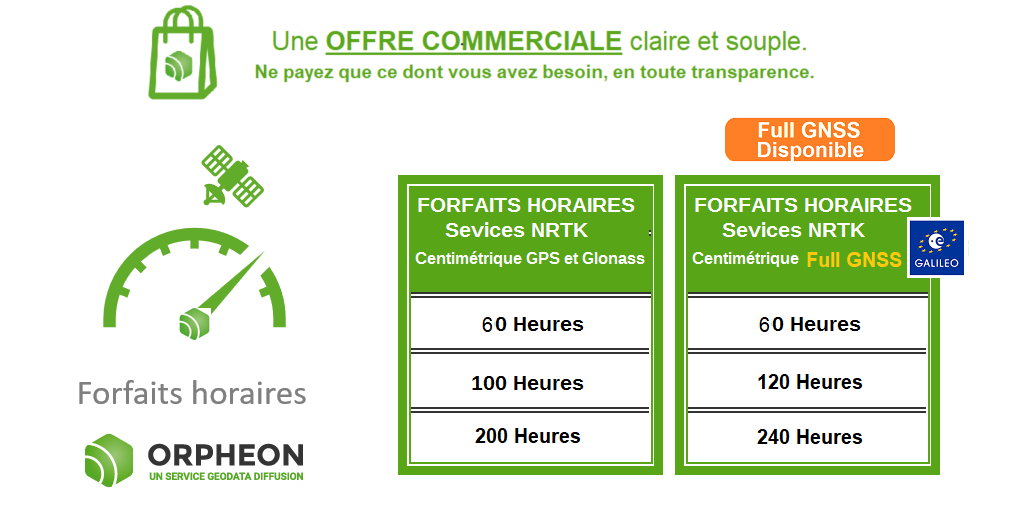
Hourly Packages
The non-binding offer :
-
-
-
- You can renew an existing plan and switch from a GPS+Glonass plan to Full GNSS and vice versa.
- There is no obligation to renew your package identically, as well as for the durations.
- Renewals are not automatic (this is the principle of the non-binding package).
- Packages can be renewed at any authorized distributor in the Orphéon network
- As usual, we inform you when your consumption reaches 90% of your package or at the beginning of the expiry month by preparing the pre-filled renewal proposal.
-
-
The geometric regularity of our layouts
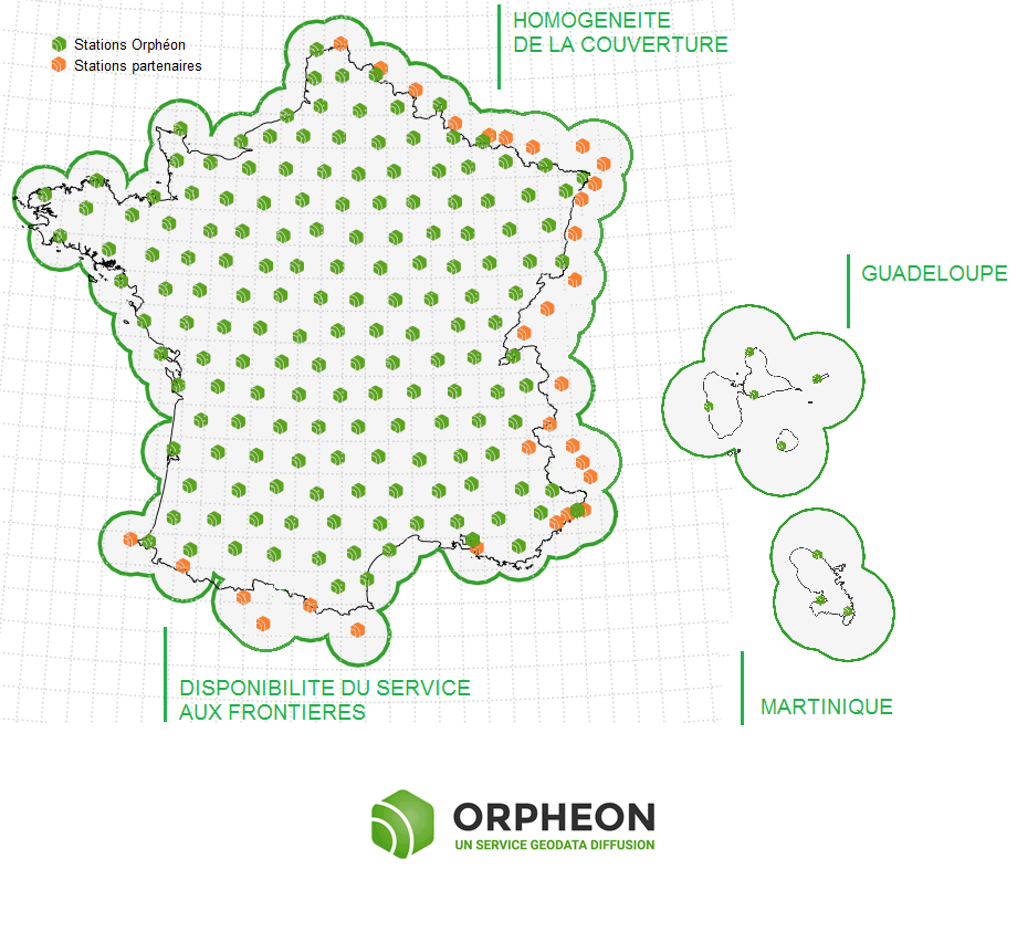
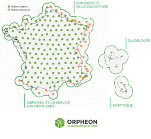
The Orphéon network has 215 stations in mainland France, all Full GNSS, i.e.: GPS, GLONASS, Galileo and BeiDou, as well as a historical presence in the French West Indies. The dense network of permanent stations is arranged regularly every 60 km. Each link in the Orphéon infrastructure has been designed to offer a high-precision RTK correction service available in all circumstances. Border areas are complemented by our partnership agreements within Europe.Click on the interactive map of the Orphéon network
-
A very regular presence, without compromise and without equivalent in France.
- The careful choice of layout for each of our 195 reference stations creates a linear and regular geometric mesh. Territory coverage is uniform wherever you are.With the Orphéon network, you work with identical precision throughout the territory thanks to a uniform distribution of stations over all the areas covered, whatever your position, the distance from the nearest reference station is never more than 30 km.The Orphéon network thus stands out significantly from its competitors who are multiplying the number of reference stations because of their disorderly location on the territory and whose coverage is losing homogeneity, sometimes leaving very large distances in the meshes of their network.
A regular and homogeneous layout
Coverage area
 The position of the mobile GPS sent to the server must imperatively be located in the network coverage area but also in the restricted area stipulated when subscribing to the service.
Outside the coverage area of the Orpheon network, the server is not able to provide the corresponding corrections. Our coverage area is defined by the position of our permanent observation stations.
Pay attention to the geographical restriction of your subscription, the server will end the connection and add an error message to the connection log (see Customer Area)
If the mobile GPS returns a position outside the subscription zone
The position of the mobile GPS sent to the server must imperatively be located in the network coverage area but also in the restricted area stipulated when subscribing to the service.
Outside the coverage area of the Orpheon network, the server is not able to provide the corresponding corrections. Our coverage area is defined by the position of our permanent observation stations.
Pay attention to the geographical restriction of your subscription, the server will end the connection and add an error message to the connection log (see Customer Area)
If the mobile GPS returns a position outside the subscription zone
- National: no restrictions Regional: the administrative region stipulated during the subscription (or 4 contiguous departments) Departmental: the administrative department stipulated during the subscription
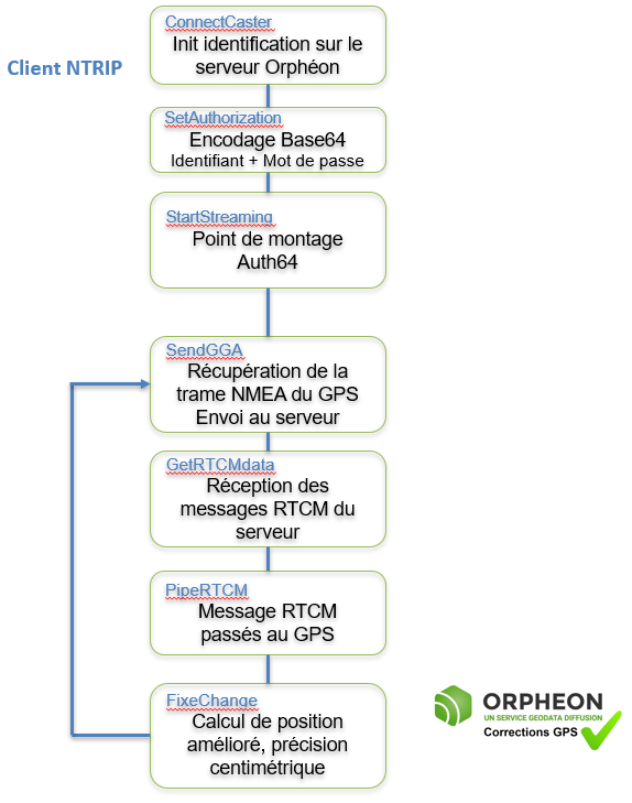
Sending a GGA-type NMEA frame
When connecting, it is important to send a GPGGA-type NMEA frame with the position of the mobile GPS. This position will allow the server to define a cell of several network observation stations around the user and thus be able to provide the corrections corresponding to the position. Caution: If no frame is sent to the server, the error message No GPGGA message received. Access denied is added to the error log (see Customer area). Similarly, if the position sent is zero (all zero) the message Currently no data available. No sites and/or clusters defined. is added to the error log (see Customer area).The real strength of the Orpheon network
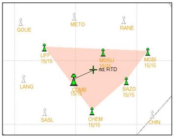
The NRTK (Network Real Time Kinematic) comes from the use of several bases of observations connected together in a network to optimize and model the information of corrections on the covered area. the positioning accuracy does not depend on the distance to the nearest physical network station.Regional coverage or 4 adjacent departments :
- The 4 departments of your choice must touch each other to create a continuous area
- Examples
- 62-59-80-02
- 62-59-08-55
- 62-59-80-60
- 62-59-80-76
- 62-59-02-51
- 62-59-02-77
- 62-59-02-60
- you can’t take for example
- 62-59-51-55
- 62-59-60-77
- etc
- exemples
Departmental coverage
Define your work department and benefit from Full GNSS corrections for a suitable price. A department of your choice including the West Indies*:
- The real-time geo-positioning correction data stream over the entire work area defined when subscribing to the service. These corrections make it possible to improve the precision of geopositioning by real-time differential GNSS methods (GPS, Glonass) real-time with a centimetric (N-RTK) or decimetric (N-DGNSS) level of precision depending on the subscribed service.
- The choice of GPS only or GPS + Glonass option.
- Access to 50 annual hours of RINEX files drawn from the ORPHEON permanent physical GNSS station network. These files make it possible to improve the precision of geopositioning by differential methods in deferred time.
- Access to 2 hours per year of RINEX files drawn from the network of virtual GNSS stations generated from coordinates specified by the SUBSCRIBER. These files make it possible to improve the precision of geopositioning by differential methods in deferred time.
- The real-time geo-positioning correction data stream over the entire work area defined when subscribing to the service. These corrections make it possible to improve the precision of geopositioning by real-time differential GNSS methods (GPS and Glonass) real-time with a level of centimetric precision (N-RTK) depending on the subscribed service.
- Access to 50 annual hours of RINEX files drawn from the ORPHEON permanent physical GNSS station network. These files make it possible to improve the precision of geopositioning by differential methods in deferred time.
- Access to 2 hours per year of RINEX files drawn from the network of virtual GNSS stations generated from coordinates specified by the SUBSCRIBER. These files make it possible to improve the precision of geopositioning by differential methods in deferred time.
- Under certain conditions, it is possible to change the centering point during the subscription (See conditions)
Work in network mode within a cell
Contact commercial information :
In order to offer offers perfectly adapted to the needs of users, we have designed several subscription formulas or hourly packages. Our commercial offer is clear and very flexible. So, in complete transparency, you only pay for what you really need. > Click sur le lien suivant to find all the details on the page : Découvrir nos offresFor more information, you can contact our sales department:
Tél : 01 69 18 81 60
Fax : 01 69 18 81 61
Mail : contact@geodata-diffusion.fr
Ou accéder au Formulaire de contactMarketing
Find your distributor
Marketing
Find your distributor
As a reminder, in order to be able to position itself within a few centimeters, a GPS/GNSS rover must be able to:
- perform noise-free phase measurements on at least 5 satellites well distributed in space,
- and receive differential corrections on these same 5 satellites.
How does it benefit you on a daily basis?
100% more satellites
The addition of the Galileo and BeiDou satellites to the GPS and GLONASS satellites significantly increases the number of satellites that can be observed simultaneously by a GNSS antenna. The addition of the GALILEO and BeiDou constellations thanks to the Orphéon network is not a simple gadget, but the assurance of better daily productivity in the field. Indeed, you can now permanently count on the constant availability of at least 6 additional satellites to bring you real advantages:Improved positioning quality
- More satellites available to calculate its position
- Precise positioning even in difficult environments (urban canyons for example or under a canopy)
- Improved positioning reliability
- Shorter fixing time
The densest and most regular coverage area in France
A multi-constellation network
With its 215 stations in mainland France, all Full GNSS: GPS, GLONASS, Galileo and BeiDou with a unique presence in the French West Indies.
Orphéon is the first French multi-constellation network in France.
Learn more: : See the page : Work in difficult places Contact our Technical Service who will bring you concrete help and guide you step by step.
Constellations already operational today :
05/11/2017For GALILEO,
There are currently between 4 and 5 functional satellites which are permanently available for your positioning and the FULL GNSS corrections of the network.

The only Galileo corrections already available in France
Of course, the European system, which today has 16 satellites in orbit, will continue to develop and expand with the forthcoming launch of 4 new satellites, but their number already makes it possible to make a difference and to work in better conditions.
For BeiDou,
There are also between 1 and 4 satellites permanently available for your positioning and the FULL GNSS corrections of the network.
Multi-frequency L1/L2 and L5
Based on L1 and L5 frequencies emitted by satellites to make positioning more resistant to interference and signal reflections, especially in an urban environment. Everything has been thought out to allow you to benefit from increased productivity.- Centimeter accuracy corrections for GPS GNSS
- Use of L1/L2 and L5 frequencies
- Real time, very fast convergence time
- A dense and homogeneous RTK network
- A regular and geometric implantation on the whole territory
- An infrastructure designed for service performance
- Very secure facilities
- National and West Indies coverage
- A reference for professionals
- Accuracy, Stability, Availability, Repeatability
- Increasingly varied applications
For you, in the field 6 additional satellites,
Sur le terrain, vous pouvez donc compter en permanence sur une disponibilité constante d’au moins 6 satellites supplémentaires.
Le cumule de ces 2 constellations supplémentaires font aujourd’hui une réelle différence pour votre productivité.Il n’est donc pas besoin d’attendre 2020 pour tirer le meilleur partie de vos équipements Full GNSS.
Profitez dès à présent des corrections FULL GNSS disponibles sur la totalité du territoire et aux Antilles françaises.How to take advantage of the new Full GNSS services?
Already subscribed? Connect today to our real-time services from your GNSS-compatible mobile with your usual user connection parameters (username and password) and select one of our Full GNSS mount points stamped “FULL”.Settings :
- DNS: ntrip.reseau-orpheon.fr
- Port: 8500
- Mount point*: VRS_RTCM-MSM_FULL or i-Max_RTCM-MSM_FULL
Contact our Technical Service who will bring you concrete help and guide you step by step.
For the same price
GPS+Glonass subscriptions have become Full GNSS!
You now benefit, without a price increase, from an unlimited GPS + GLONASS + Galileo + BeiDou subscription in addition to our new online Post-Processing & RINEX Download services, whether your subscription is: Local, Departmental, Regional or National. With your Orpheon subscription, you therefore have access to:- An unlimited Full GNSS real-time centimetric correction service
- An online RINEX Full GNSS Post-Processing service
- An online service for downloading RINEX Full GNSS
- A web platform providing access to your account, your subscriptions and the state of the Orphéon network
- A Smartphone application offering the same functions as the Web platform
How to take advantage of the new Full GNSS services?
Connect today to our real-time services from your GNSS-compatible mobile with your usual user connection parameters (username and password) and select one of our Full GNSS mount points stamped “FULL”.Settings :
- DNS: ntrip.reseau-orpheon.fr
- Port: 8500
- Mount point*: VRS_RTCM-MSM_FULL or i-Max_RTCM-MSM_FULL
30% Discount to upgrade your hourly Package to a subscription
You have subscribed to a real-time hourly package, benefit from a discount of up to 30% of the value of your current package for any subscription to an unlimited subscription and benefit from the RINEX Post-processing & Downloading web application in plus Full GNSS real-time corrections as described above. Depending on your specialty, contact your usual distributor without hesitation (Find your Orpheon distributor), he will know, better than anyone, how to answer you and support you in your projects.For the same price
GPS+Glonass subscriptions have become Full GNSS!
You now benefit, without a price increase, from an unlimited GPS + GLONASS + Galileo + BeiDou subscription in addition to our new online Post-Processing & RINEX Download services, whether your subscription is: Local, Departmental, Regional or National. With your Orpheon subscription, you therefore have access to:- An unlimited Full GNSS real-time centimetric correction service
- An online RINEX Full GNSS Post-Processing service
- An online service for downloading RINEX Full GNSS
- A web platform providing access to your account, your subscriptions and the state of the Orphéon network
- A Smartphone application offering the same functions as the Web platform
How to take advantage of the new Full GNSS services?
Connect today to our real-time services from your GNSS-compatible mobile with your usual user connection parameters (username and password) and select one of our Full GNSS mount points stamped “FULL”.Settings :
- DNS: ntrip.reseau-orpheon.fr
- Port: 8500
- Mount point*: VRS_RTCM-MSM_FULL or i-Max_RTCM-MSM_FULL
30% Discount to upgrade your hourly Package to a subscription
You have subscribed to a real-time hourly package, benefit from a discount of up to 30% of the value of your current package for any subscription to an unlimited subscription and benefit from the RINEX Post-processing & Downloading web application in plus Full GNSS real-time corrections as described above. Depending on your specialty, contact your usual distributor without hesitation (Find your Orpheon distributor), he will know, better than anyone, how to answer you and support you in your projects.- To post-process with data from Orpheon network stations your raw GNSS data recorded in the field in RINEX format, whether physical stations but now also with calculated virtual stations.
- Download raw GNSS data in RINEX format from the physical stations of the Orphéon network in order to carry out personalized post-processing.
- Constant centimetric precision Full GNSS, GPS + Glonass + Galileo + BeiDou
Download the PDF leaflet :
Depending on your work environment and the usual platform on which your GPS is connected. This dedicated platform offers all our customers various services that complete access to your real-time GNSS corrections. It also allows you to freely consult:
- The status of the Orpheon GNSS network
- Your personal information
- The contracts you have entered into
- Your connection history
- The remaining credit on your hourly rate
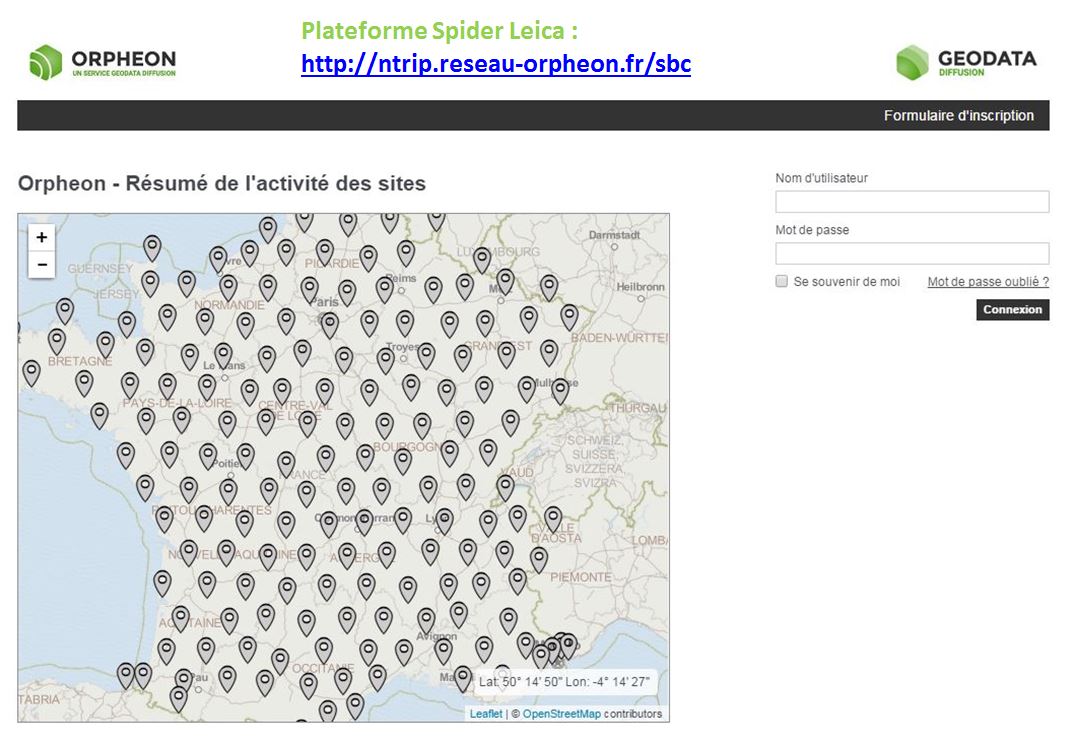
- Plateforme Spider Leica : http://ntrip.reseau-orpheon.fr/sbc
 With your smartphone
To access this information wherever you are, connect by flashing the QR-code below corresponding to the dedicated platform on which your GPS is usually connected:
Application download:
Click on the image below to access more information about our Smartphone applications and its features.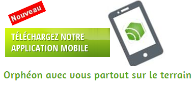
Since October 2, 2017, Géodata Diffusion has offered all of its users a web application complementary to real-time services allowing:
- To post-process with Orphéon data and in the network the raw GNSS data recorded in the RINEX format in the field,
- Download raw GNSS data in RINEX format from Orpheon reference stations in order to perform personalized post-processing.
In both cases, the raw data from the stations and the post-processing are “Full GNSS” (GPS, Glonass, Galileo and BeiDou) and available online for thirty days (more on request).
Benefits of the Orpheon Post-Processing Service
Post-processing is a real added value for GNSS data users and can easily be integrated into your usual workflow as it allows to:
- Work in all areas not covered by GPRS (white and gray telephony areas),
- Control the quality of your data for complex or demanding projects,
- Increase productivity thanks to a simplified post-processing chain,
- Obtain results of optimized quality thanks to a network calculation,
- Benefit from directly georeferenced and usable data.
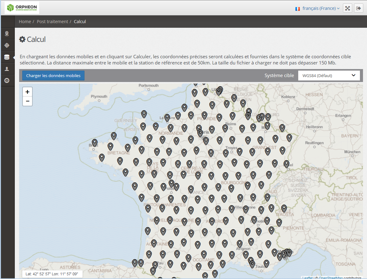
How to take advantage of RINEX Post-Processing & Downloading service ?
Chaque abonnement temps réel permet de bénéficier gratuitement, sans souscription supplémentaire, d’un forfait de 50 heures de Post-traitement & Téléchargement de RINEX, à utiliser sur 12 mois.
These services are accessible on the Orphéon platform at the address http://ntrip.reseau-orpheon.fr/sbc with your usual user connection parameters (username and password).
A simplified operation in 3 steps
- Importing RINEX data from the mobile to Post-Process on the site
- Execution of Post-Processing calculations
- Calculation report
For the same price
Included in Full GNSS subscriptions!
You now benefit, without a price increase, from an unlimited GPS + GLONASS + Galileo + BeiDou subscription in addition to our new online Post-Processing & RINEX Download services, whether your subscription is: Local, Departmental, Regional or National.
With your Orpheon subscription, you therefore have access to:
- An unlimited Full GNSS real-time centimetric correction service
- An online RINEX Full GNSS Post-Processing service
- An online service for downloading RINEX Full GNSS
- A web platform providing access to your account, your subscriptions and the state of the Orphéon network
- A Smartphone application offering the same functions as the Web platform
 RINEX Online & Download Post Treatment Packages
We have just created specific hourly packages Online Post-Processing & RINEX Download for customers who do not need real-time correction or for customers who have a greater need than the 50 hours already included in their subscription.
We now offer as standard different specific packages to choose from:
- 60 Hours Online Post-Processing & RINEX Download
- 100 Hours Online Post-Processing & RINEX Download
- 200 Hours Online Post-Processing & RINEX Download
- Specific Quantities* Online Post-Processing & RINEX Download
* Depending on your specialty and your needs, contact your usual distributor without hesitation (Find your Orpheon distributor), he will know, better than anyone, how to answer you and support you in your projects.
30% Discount to upgrade your real-time package to a subscription
You have subscribed to a real-time hourly package, benefit from a discount of up to 30% of the value of your current package for any subscription to an unlimited subscription and benefit from the RINEX Post-processing & Downloading web application in plus Full GNSS real-time corrections as described above.
Depending on your specialty, contact your usual distributor without hesitation (Find your Orpheon distributor), he will know, better than anyone, how to answer you and support you in your projects.
- Status of your Mobile
- Real-time network status
- Check your NTRIP connection
- Your personal information
- Your contracts
- Contact us
- Settings
From today, find the Orpheon application
For downloading the Orpheon application
Directly on the Apple Store or on Google Play:
Click on the image below to access more information about our Smartphone applications and its features.Flash the QR code with your Smartphone to access the download page of the Apple Store or Google Play. Once the application is downloaded, you can benefit from additional information which will follow you everywhere in the field.


Using the Orpheon app
Simple Connection
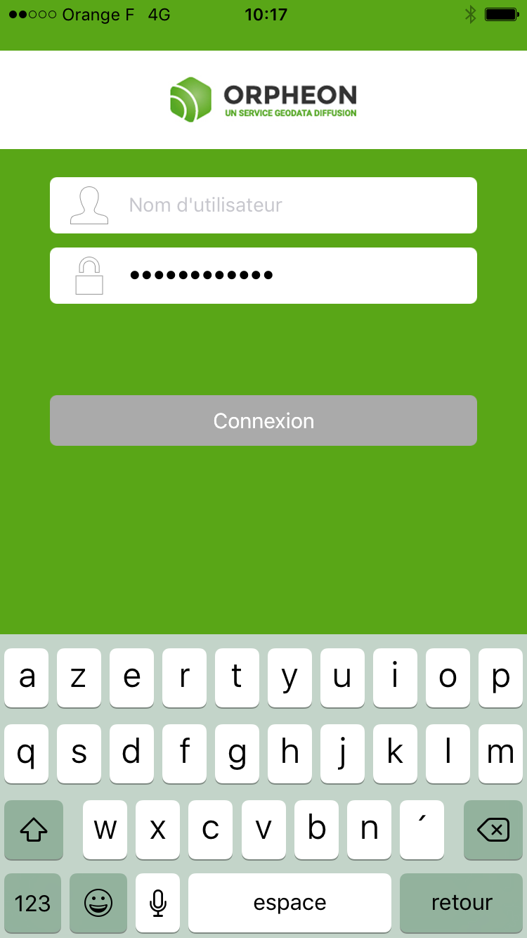 Using your username and password you can log in to the application.
The different menus
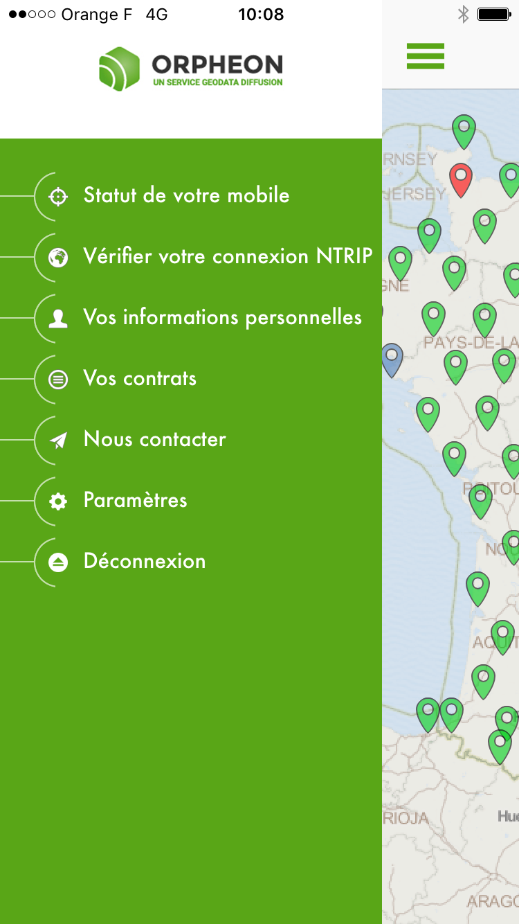
Status of your mobile
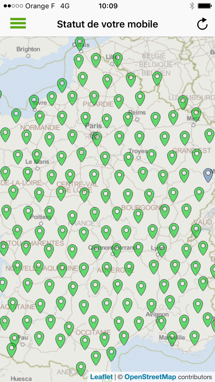 With a simple glance, check the status of your mobile and its connection, but also you can consult the status of the entire network.
Check your NTRIP connection
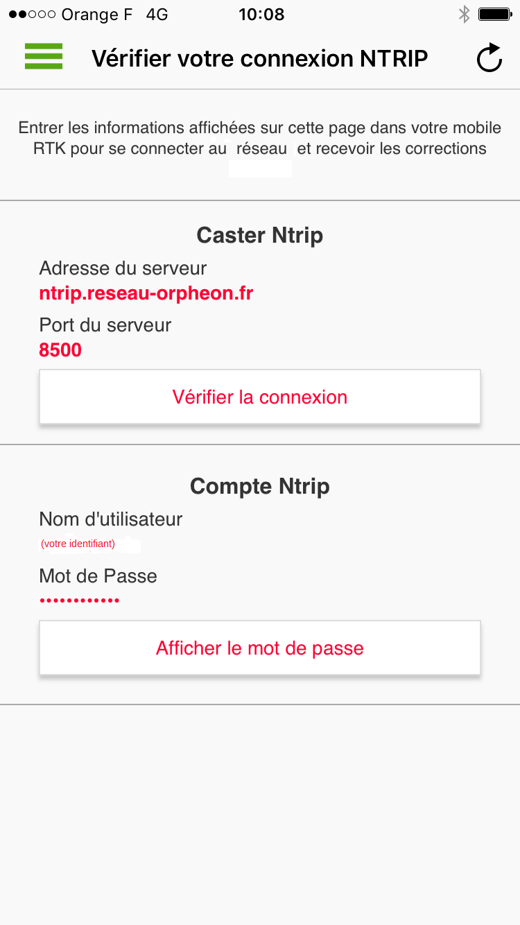 Connection information directly accessible for the configuration of your mobile
Your personal information
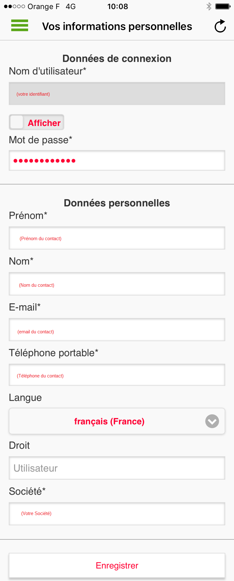 You can view the contact information associated with the account used.
This information complies with our privacy policy.
You can view the contact information associated with the account used.
This information complies with our privacy policy.
Your contracts
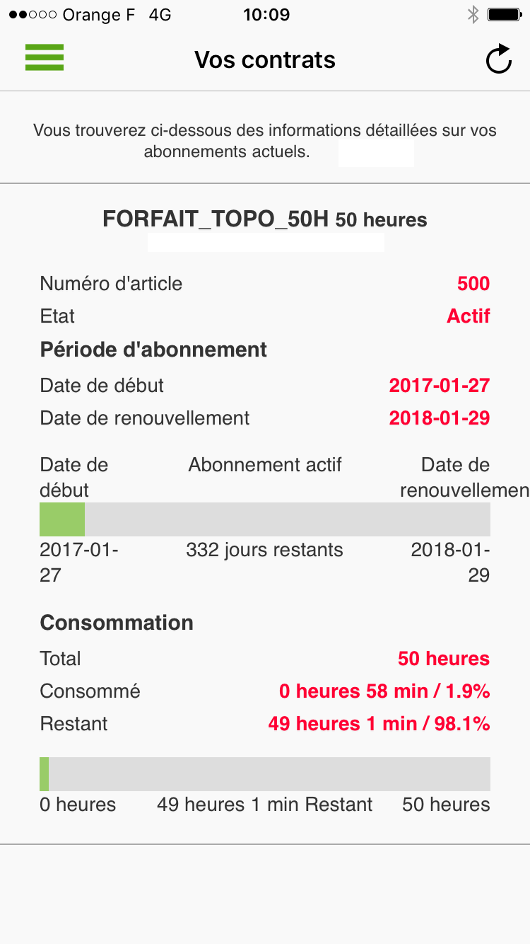 You can consult the information associated with all the contracts linked to your account. You can thus control the consumption of your plan or the remaining time.
Contact us
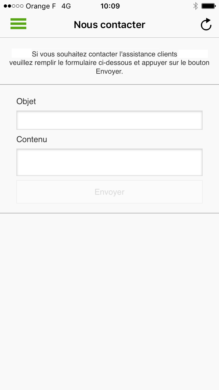 You can message us directly
Configuration setting
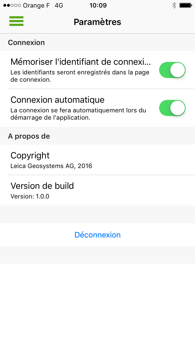 Application configuration settings on your smartphone
Your customer area
The Customer Area offers all our customers various services that supplement access to your real-time GNSS corrections. The Orphéon network offers, thanks to its user interface, tools that facilitate your daily work or the development and integration of precision GPS chips in your projects. Check your connections in real time, consult logs or view your trajectories makes your work easier and saves time. but also post-process your work directly online.Go straight to the point!
Find your login information and log in using your username and password, on one of the following platforms:- Plateforme Spider Leica : http://ntrip.reseau-orpheon.fr/sbc
With your smartphone
To access this information wherever you are, connect by flashing the QR-code below corresponding to the dedicated platform on which your GPS is usually connected:
Plateforme Spider Leica :

Depending on your work environment and the usual platform on which your GPS is connected. This dedicated platform offers all our customers various services that complete access to your real-time GNSS corrections. It also allows you to freely consult:
Consult freely:
-
-
- Orpheon GNSS network status
- Your personal information
- The contracts you have taken out
- Your login history
- The remaining credit on your hourly rate
- History of your e-bills
-
Your tools
-
-
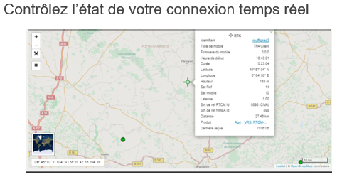
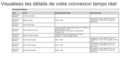
- Viewing your real-time connections
- Check your connection and settings
- Analyze your connections (logbook)
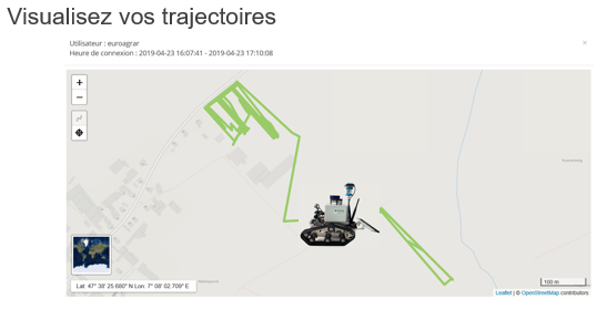
- Visualize your trajectories
- Perform Online Post Processing
- Change of reference system online
- Download Rinex from Orpheon Stations
-
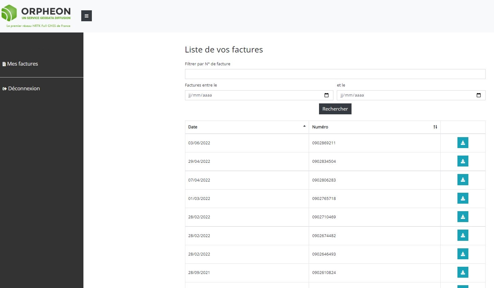
History of your e-invoices:
*Available, if you are billed by Geodata Diffusion directly for your subscriptions or packages and you have accepted the dematerialized billing method (see the dedicated e-bill page). Easily find the history of your invoices on your customer area: https://fr.nrtk.eu/SBC/ Log in to your space with your username and password.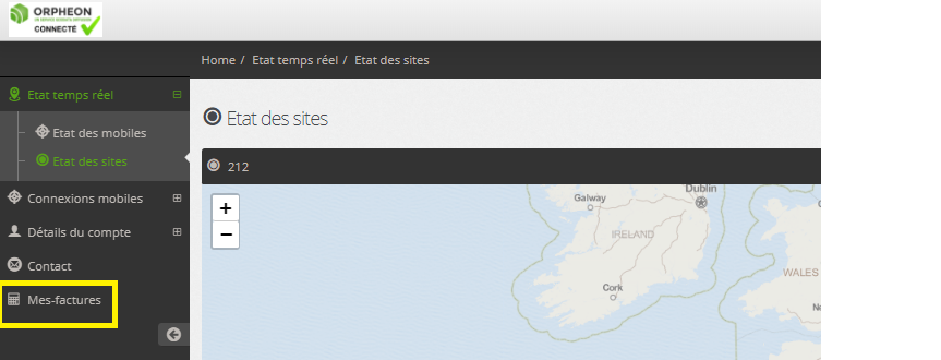
History of your connections:
View the Usage Report
Select the predefined period or a custom scale for which you want to see the list of your connections. From this list you can access the log of each of your connections as well as a summary of your trajectory. You can export the list in CSV format for editing your custom reports.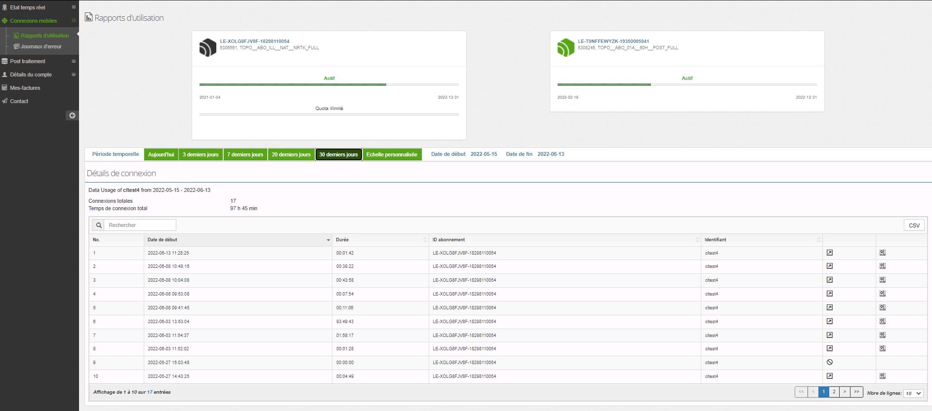
 This approach is part of a desire to improve the quality of our services and simplify our exchanges. We hope that this additional information will satisfy you.
 You can request (See dedicated e-invoice page) to receive your dematerialized invoices in PDF format by e-mail, simply fill in the form below. The rate of invoicing will remain unchanged corresponding to the subscription of your annualized or monthly contract.
You must provide us with a valid and long-lasting email address in order to properly receive your invoices. Upon receipt of your request, we will confirm the implementation of dematerialized invoicing.
You can request (See dedicated e-invoice page) to receive your dematerialized invoices in PDF format by e-mail, simply fill in the form below. The rate of invoicing will remain unchanged corresponding to the subscription of your annualized or monthly contract.
You must provide us with a valid and long-lasting email address in order to properly receive your invoices. Upon receipt of your request, we will confirm the implementation of dematerialized invoicing.

History of your e-invoices*:
*Available, if you are billed directly by Geodata Diffusion for your subscriptions or packages and you have accepted the dematerialized billing method.
History: you will find in your customer area all the electronic invoices generated directly by Geodata Diffusion for each of the corresponding subscriptions that are still active and even terminated.
If you have other subscriptions but these are invoiced to you by our distributor, these accounts and these invoices will not appear in your history.
Easily find the history of your invoices on your customer area : https://fr.nrtk.eu/SBC/
Log in to your space with your username and password.
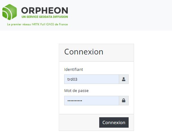
Enter your username and password (provided by Geodata) for the secure connection.
Your usernames and passwords:
When confirming each of your subscriptions, we create an individual username and password for the use of the corresponding correction service. It is exactly these identifiers and passwords that allow you to connect and view your invoices.
 View and download the invoices you need
Tip: If you have several subscriptions, simply log in with the username and password of your oldest subscription.
Indeed, your first subscription allows you to supervise everything and find all your invoices that you can download.
Note: a terminated account can still access its customer area and can thus still access the corresponding invoices on the one hand, but also if this account is the oldest, it remains the supervisor and still allows all invoices to be viewed. of your other subscriptions.
At Geodata Diffusion:
Our invoices are created automatically, sent, received and stored in electronic format (PDF) by our integrated management software package system, under the legal conditions in force. The result of this digitization is the true copy of the original, identical to the invoices that we previously produced in paper format.GPRS Option: Mobile Internet
Offer reserved for professionals subscribed to GPS corrections. In order to receive your positioning data via mobile Internet (GPRS), your GPS receiver must be equipped with an active SIM card from a mobile telephone operator. If you don’t already have one, it will be essential to equip yourself with one. We wanted this point not to penalize your budget, and have therefore developed strong partnerships with the French mobile telephone operators Orange and SFR. Thus, we offer with all our subscriptions, the SIM card at an exceptional price.Offer reserved for subscribers of GPS corrections.
In order to receive your positioning data via the GPRS network, your GPS receiver must be equipped with an active SIM card. If you don’t already have one, it will be essential to equip yourself with one. However, we wanted this point not to penalize your budget, and have therefore developed strong partnerships with the French mobile telephone operators Orange and SFR. Thus, we offer with all our subscriptions, the SIM card at an exceptional price.Learn more : See the page : Choice of SIM cards Discover the offers
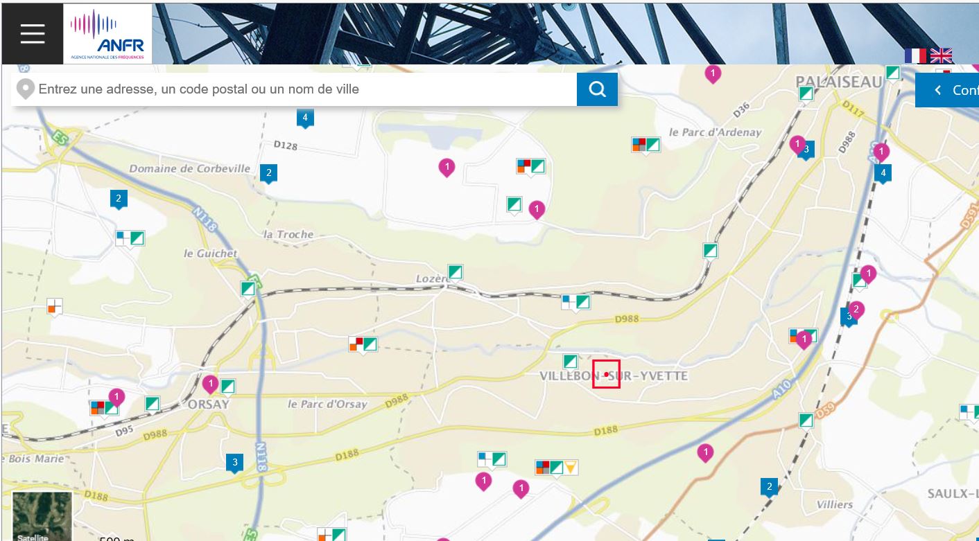
In order to determine what is the level of coverage for your mobile internet access in the area in which you wish to work, there are two official sites
1/ The ARCEP website :
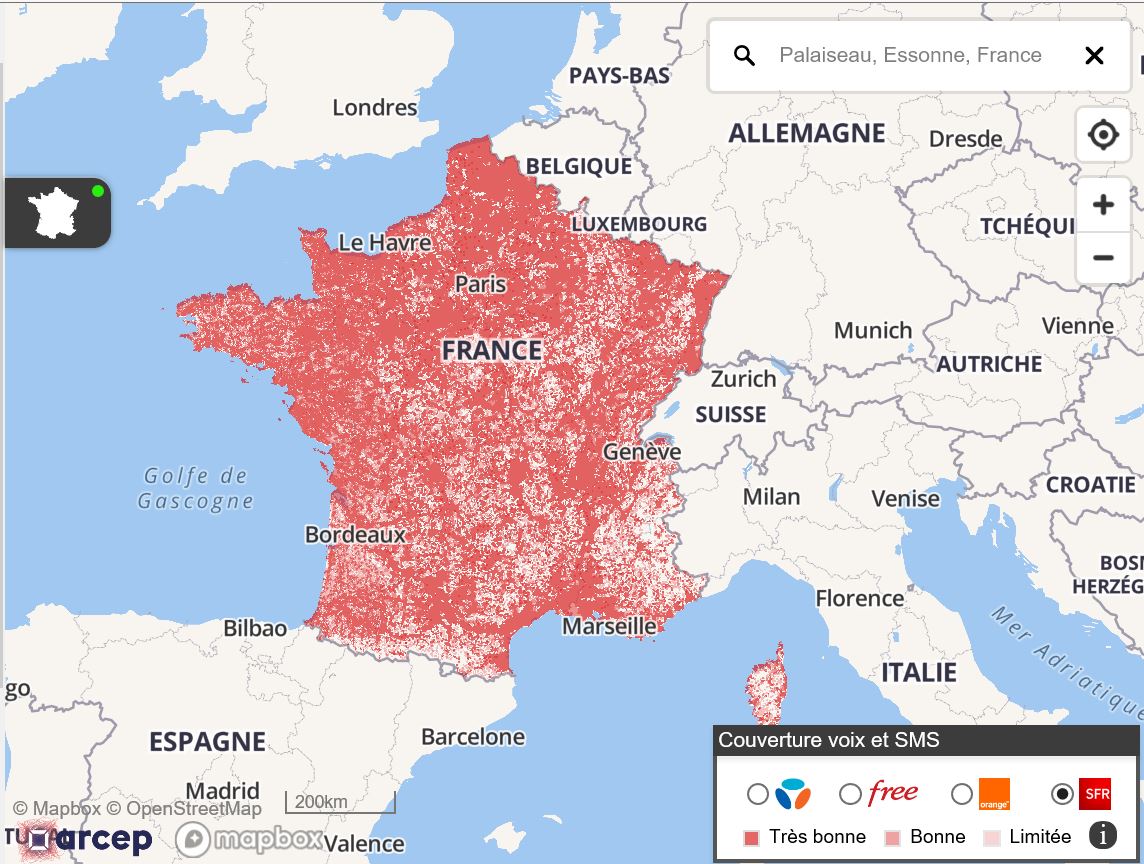
2/ the ANFR website
Important: depending on the type of card or the age of the contract, the Roaming option must be activated
For many years at Geodata Diffusion we have been providing our customers with SIM cards. Since then, the legislation and invoicing rules for the Roaming Europe option have changed a great deal. Some of the cards delivered before these changes did not have the Europe option activated because at the time this option was chargeable and led to significant additional costs for exceeding the package. Today these options have become free and no longer generate unpleasant surprises. In general, roaming at national rates, which allows you to use your mobile plan from abroad without being surcharged, only applies to occasional use. Your consumption from France must be the majority. Could I use my mobile Internet volume in the European zone? You can use your monthly mobile Internet volume both in the European zone and in mainland France(1). For example, if your package includes 5 GB of internet and you use 2 GB while working in Germany, you will have 3 GB of your package left when you return to France. If your mobile Internet volume runs out, one of the following pricing conditions will apply until the date your plan is reset (depending on the mobile offer you have): – reduced flow, – blocking your blocked mobile internet, – off-package at the rate applicable in mainland France.Access to the Orpheon network
It should also be noted that mobile Internet access abroad does not systematically give access to the Orphéon network. For this, reference should be made to the network coverage area (Metropolitan France and the West Indies). To simplify, the Roaming Europe option is mainly useful for our customers working on the edge of borders, when their equipment “terminal” on a relay in the neighboring country. For remote countries, it will be necessary to take out an RTK subscription in the country concerned (example in England, Poland, etc.). We also recommend that you take out an RTK SmartNet subscription.For Orange SIM cards:
Since October 1, 2019, automatically and without changing the offer: you have nothing to do! These changes apply automatically and free of charge to your package. The destinations included in your package for your trips in the European zone Europe Azores (the), Aland (islands), Germany, Austria, Balearic Islands, Belgium, Bulgaria, Canaries (islands), Cyprus, Corfu (island), Crete, Cyclades (the), Croatia, Denmark, Spain, Estonia, Faroe (islands ), Finland, Gibraltar, Greece, Guernsey, Hungary, Ireland, Iceland, Italy, Jersey, Latvia, Liechtenstein, Lithuania, Luxembourg, Madeira, Malta, Man (Island), Norway, Netherlands, Poland, Portugal, Czech Republic , Rhodes (island of), Romania, United Kingdom, San Marino, Sardinia, Sicily, Slovakia, Slovenia, Sweden, Vatican DOM Guadeloupe, French Guyana, Martinique, Réunion and certain overseas communities: Mayotte, Saint-Barthélemy, Saint-Martin (island of), Saint-Pierre-et-Miquelon Switzerland/AndorraFor SFR SIM cards :
Depending on the SFR offer to which you have subscribed, it is possible to have an internet connection from the European Union and the overseas departments at no additional cost. We still invite you to check the conditions of your offer (excluding packages with blocking option and La Carte offers). If you are in the European Union or in the overseas departments, mobile internet connections are included in your SFR package. Be sure, before your departure or during your departure, to confirm the conditions of your offer. Find below the countries included in each group for SFR Mobile customers. Europe: Azores, Åland, Germany, Andorra, England, Austria, Balearic Islands, Belgium, Bulgaria, Canary Islands, Cyprus, Corfu, Crete, Croatia, Cyclades, Denmark, Scotland, Spain, Estonia, Finland, Gibraltar, Greece, Guernsey, Faroe Islands, Hungary, Ireland, Northern Ireland, Iceland, Italy, Jersey (Island of), Latvia, Liechtenstein, Lithuania, Luxembourg, Madeira, Man (Island), Malta, Norway, Netherlands, Wales, Poland , Portugal, Rhodes (Islands of), Romania, San Marino, Sardinia, Sicily, Slovakia, Slovenia, Sweden, Switzerland, Czech Republic, Vatican. The overseas departments: Guadeloupe, French Guiana, Martinique, Réunion, St Barthélemy, St Martin (French West Indies), St Pierre and Miquelon, Mayotte, La Désirade, Marie Galante, Saintes Islands.For Multi-Operator SIM cards :
If you are in the European Union or the French overseas departments, mobile internet connections are included in your Multi-Operator plan. Be sure, before your departure or during your departure, to confirm the conditions of your offer. Find below the countries included in each group. Europe: Azores, Åland, Germany, Andorra, England, Austria, Balearic Islands, Belgium, Bulgaria, Canary Islands, Cyprus, Corfu, Crete, Croatia, Cyclades, Denmark, Scotland, Spain, Estonia, Finland, Gibraltar, Greece, Guernsey, Faroe Islands, Hungary, Ireland, Northern Ireland, Iceland, Italy, Jersey (Island of), Latvia, Liechtenstein, Lithuania, Luxembourg, Madeira, Man (Island), Malta, Monaco, Norway, Netherlands, Wales , Poland, Portugal, Rhodes (Islands of), Romania, San Marino, Sardinia, Sicily, Slovakia, Slovenia, Sweden, Switzerland, Czech Republic, Vatican. The overseas departments: Guadeloupe, French Guiana, Martinique, Réunion, St Barthélemy, St Martin (French West Indies), St Pierre and Miquelon, Mayotte, La Désirade, Marie Galante, Saintes Islands.- Switch off your GPS, remove and clean the SIM card contacts using a soft, dry cloth.
- Replace the SIM card, turn on your GPS. If the problem persists, pass test .2 (cross tests)
- Test 2: Insert your SIM card in another GPS or failing that in a switched off mobile phone, then switch it on again. If the problem persists go to test .3
- Test 3: Test another SIM card in your off GPS, then turn it back on
Contact our Technical Service who will bring you concrete help and guide you step by step.
- For changes to the type of SIM card (change of formula or operator), a lump sum of €60 excluding costs for setting up the new card, management for the modification of the existing contract and shipping costs will be due for each of the cards to be modified.
- The new SIM cards will be active upon receipt by the Customer and will be taken into account in the contract at that time. For monthly invoicing, the rate change will take place during the invoicing deadline following the request. For annual invoicing, a new adjustment invoice will be issued taking into account the annual period remaining to be covered.
- For SIM card tests or trials for whatever reason, a lump sum of €40 excluding tax for activation costs of the card to be tested, management of the test period and shipping costs will be due for each of the desired cards.
- The new SIM cards will be active upon receipt by the Customer.
- For changes to the type of SIM card (change of formula or operator), a lump sum of €40 excluding costs for setting up the new card, management for the modification of the existing contract and shipping costs will be due for each of the cards to be modified.
- The old replaced cards must then be returned by the SUBSCRIBER within 30 days of the installation of the new cards in accordance with article 5.6. for the return of SIM cards:
- For monthly invoicing, the rate change will take place during the invoicing deadline following the request. For annual invoicing, a new adjustment invoice will be issued taking into account the annual period remaining to be covered.
Hourly Packages
The hourly PACKAGE contract can be used over a period of 12 months (1 year) from the date of confirmation of the username and password, up to the number of hours of use defined in the contract subscribed by SUBSCRIBER and will end on the first of the two terms reached. As the real-time or Post-Processing and Downloading RINEX PACKAGE is not automatically renewed, the SUBSCRIBER may choose to renew the service for an equivalent or different hourly volume depending on the offer offered and available on the day of renewal at the authorized DISTRIBUTOR of his choice. For this, the renewal must systematically be the subject of a contract duly completed and signed or validated on the internet or one of the applications offering this possibility. Upon renewal, to facilitate use and configuration for the SUBSCRIBER, the contract numbers, identifiers and passwords will remain unchanged (unless specifically requested by the SUBSCRIBER).Follow-up on the Customer Area
The Customer Area https://fr.nrtk.eu/SBC/ offers the SUBSCRIBER various services supplementing access to real-time GNSS corrections with, in particular, information on the credit remaining on his hourly PACKAGE thanks to a count to the second so that the SUBSCRIBER can fully anticipate the expiry date or the exhaustion of his remaining credit.Mobile Internet SIM Cards
The SIM cards provided for the duration of the plan are renewable with the plans at the same time as these. These SIM cards remain the property of Géodata Diffusion. As such, in the event of non-renewal of the hourly package to which they are attached, they must be returned by the user within 30 days from the end of 12 months since the date of subscription of the last Package or after the effective date of termination of the Package. SIM cards should be sent to GEODATA DIFFUSION headquarters. Géodata Diffusion Immeuble Le Viking 32, Avenue de la Baltique 91140 Villebon-sur-Yvette – France In the event of non-return, a penalty of €100 excluding tax per SIM card will be applied and invoiced to the SUBSCRIBER.In the event of non-return, a penalty of €100 excluding VAT per SIM card will be applied and invoiced to the SUBSCRIBER
Sending a GPGGA-type NMEA frame
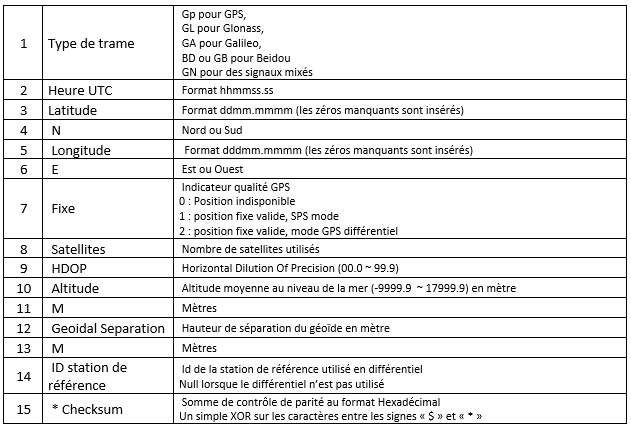
When connecting, it is important to send a GGA-type NMEA frame with the position of the mobile GPS. This position will allow the server to define a cell of several network observation stations around the user and thus be able to provide the corrections corresponding to the position. Caution: If no frame is sent to the server, the error message No GPGGA message received. Access denied is added to the error log (see Customer area). Similarly, if the position sent is zero (all zero) the message Currently no data available. No sites and/or clusters defined. is added to the error log (see Customer area).Content of the NMEA GGA frame
There are a large number of different NMEA frames, more than thirty. These frames are defined by the NMEA 0183 standard which is a specification for communication between marine equipment, including GPS. This standard uses frames or sentences to transmit information, each information is separated by a comma.| 1 | 2 | 3 | 4 | 5 | 6 | 7 | 8 | 9 | 10 | 11 | 12 | 13 | 14 | 15 |
| $GNGGA, | 073939.00, | 4841.47953, | N | 00212.97078, | E, | 1, | 24, | 0.62, | 165.7, | M, | 46.2, | M | , , | *42 |
Sending a GGA-type NMEA frame
When connecting, it is important to send a GGA-type NMEA frame with the position of the mobile GPS. This position will allow the server to define a cell of several network observation stations around the user and thus be able to provide the corrections corresponding to the position.
Maintaining connection with the server
Caution: To maintain the active connection between the GPS receiver and the Ntrip server which sends the corrections, a GGA frame (if possible updated with the real position of the GPS) must be sent regularly to the server. This measurement helps ensure that the link is truly up. If after 30 seconds no GGA frame is sent to the server, the latter considers that the link is interrupted and terminates the connection. In the error log (see Customer area) a new information message indicates: Rover user rejected. No heartbeat received.Maintaining connection with the server
Caution: To maintain the active connection between the GPS receiver and the Ntrip server which sends the corrections, a GGA frame (if possible updated with the real position of the GPS) must be sent regularly to the server. This measurement helps ensure that the link is truly up. If after 30 seconds no GGA frame is sent to the server, the latter considers that the link is interrupted and terminates the connection. In the error log (see Customer area) a new information message indicates: Rover user rejected. No heartbeat received.Steps
Without going into the details of these programs, it is interesting to understand what happens at each of these stages.
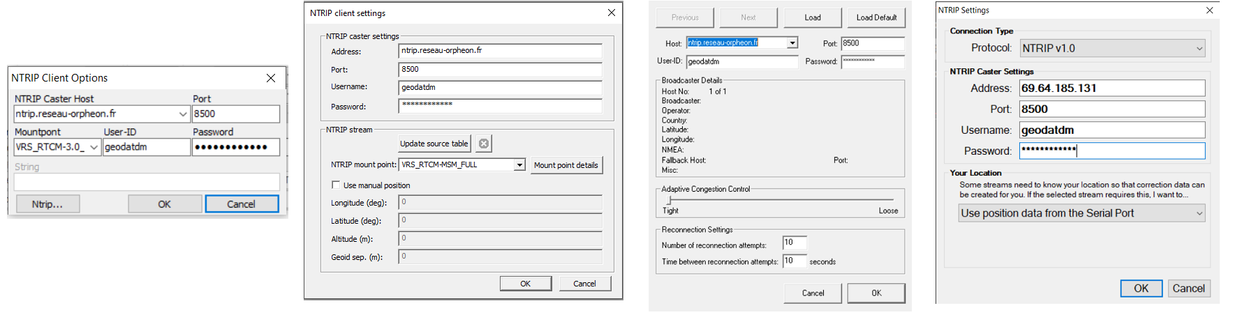
Connection to the Orpheon server via an NTRIP Client app
It is possible to connect a precision GPS module (RTK) via the USB port to a PC For this, there are several possibilities to connect to the Orpheon server to receive the corrections necessary to increase the precision of a GPS-RTK. As long as the GPS is not connected and does not receive RTCM correction messages from the Orpheon server, this GPS works like an ordinary GPS with an accuracy of several meters (natural mode). Apps The applications presented here are given by way of example because free provided by a manufacturer or available on the internet in open source.-
-
- RTKLIB
- u-center Ublox
- GNSS Internet Radio
- NTRIPClient Lefebure
-
Examples of different applications with NTRIP Client
Setings Each of these applications is configured in the same way, you must enter*:-
-
- Orpheon server address: ntrip.reseau-orpheon.fr
- Port: 8500
- The mount point: VRS_RTCM-MSM_FULL
- Identifier: geodatdm
- The password : *******
-
Steps
Whatever your hardware, the connection steps have been standardized and defined to allow everyone to access centimeter precision.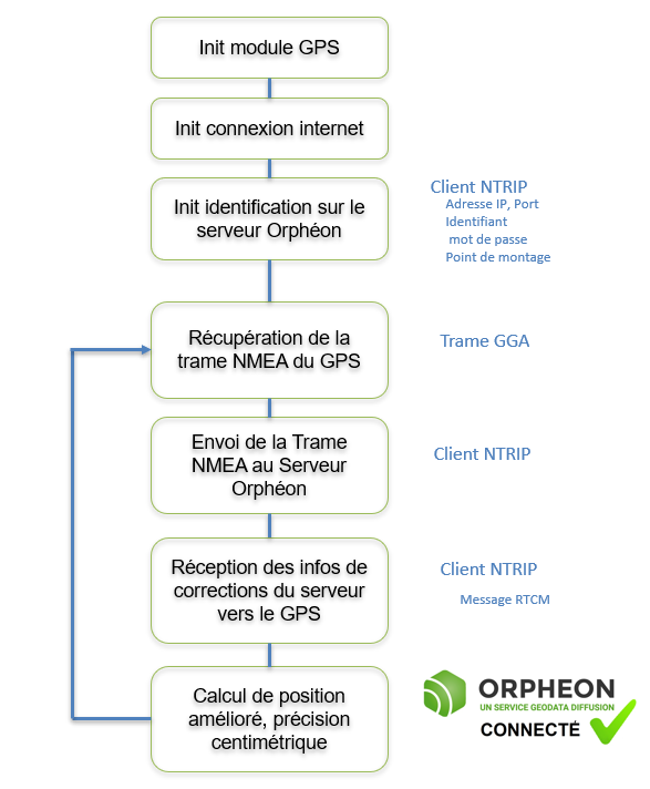
Without going into the details of these programs, it is interesting to understand what happens at each of these stages.
Find an Orpheon Distributor
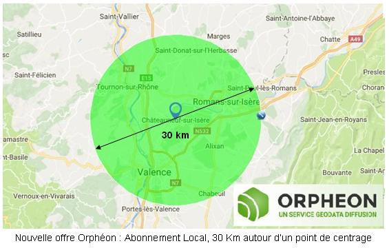
Learn more : Discover the offers New: Géodata Diffusion now offers you a new Local work area* suitable for long-term construction sites or sedentary users . More information ….
- perform noise-free phase measurements on at least 5 satellites well distributed in space,
- and receive differential corrections on these same 5 satellites.
See the page : Work in difficult places Contact our Technical Service who will bring you concrete help and guide you step by step.
- Voir la page des systèmes GPS / GNSS de Leica Geosystems.
- Voir la page des récepteurs GNSS de TopCon.
- Voir la page des systèmes GPS / GNSS de Trimble (site en anglais).
- Voir la page des systèmes GPS / GNSS de Spectra précision (site en anglais).
- Voir la page topographie / Géodésie d’Ashtech (site en anglais).
- Voir la page produits de Geomax (site en anglais)
En savoir plus : Contact our Technical Service who will bring you concrete help and guide you step by step.


