1st Configuration of my hardware:
For the first configuration of the material, it is necessary to pay attention to 2 important points
- The configuration of the mobile Internet access of my equipment via the parameters of the SIM card and the Modem.
- Make sure that your mobile Internet reception is correct in your work area and that your receiver is correctly configured, especially if you work with cards from different operators: Orange, SFR (APN corresponding to the card operator SIM).
- The configuration of the GPS application via the NTRIP settings of my subscription.
- Make sure your GNSS receiver is correctly configured (Username, Password, DNS address, mount point). The manufacturer’s manual for your receiver and the delivery note will allow you to configure it correctly.
- Make sure you are in the work area corresponding to the work area you have subscribed to in the event of a local, departmental or regional subscription.
All of these parameters are described on the delivery note sent to you by our services. Using the user manual for your equipment, follow the instructions to configure all the information step by step. Do not hesitate to contact your distributor who is perfectly familiar with this type of configuration and will help you in this step.
My equipment has already received corrections from the Orphéon network
Your hardware has already been configured correctly and you have already worked by receiving corrections from the Orpheon network, but you are unable to connect.
Here are some simple but important things to check.
- Make sure that your mobile Internet reception is correct in your work area and that your receiver is correctly configured, especially if you work with cards from different operators: Orange, SFR (APN corresponding to the card operator SIM).
- Make sure that your GNSS receiver is correctly configured (Username, Password, DNS address, mount point) or that these parameters have not been modified, especially if you share your equipment in a team with other users. The manufacturer’s manual for your receiver and the delivery note will allow you to configure it correctly.
- Make sure you are in the work area corresponding to the work area you have subscribed to in the event of a local, departmental or regional subscription.
- Make sure in the case of an hourly package that it has not expired and that you have hourly credit.
- Make sure that another mobile is not already connected with your username and password: use the Smartphone application or go to the customer portal to see if a mobile is already connected to the network.
In addition, our teams are on hand to help you check and adjust your receiver.
Learn more:
Contact our Technical Service who will bring you concrete help and guide you step by step.
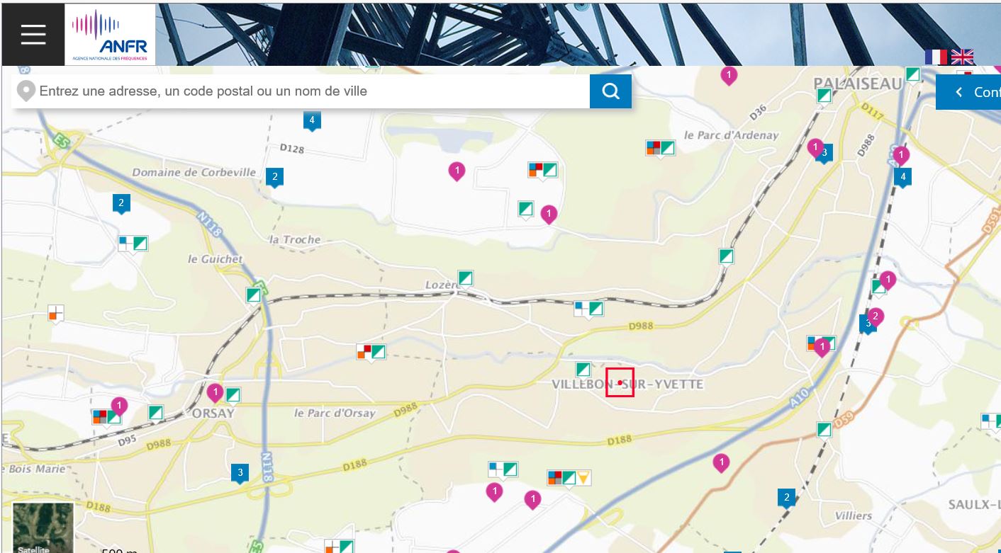
In order to determine what is the level of coverage for your mobile internet access in the area in which you wish to work, there are two official sites
1/ The ARCEP website :
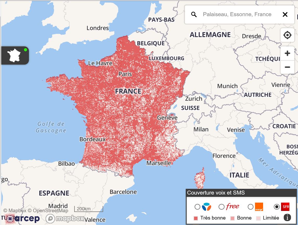
2/ the ANFR website
Two ways to simply access the network status:
- Either from the Smartphone application
- Either via the web platform
 1/ With your smartphone
To access this information wherever you are, connect by flashing the QR-code below corresponding to the dedicated platform on which your GPS is usually connected:
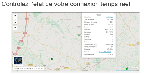
View network status live:

In the upper part of the banner, we indicate the general state, any disruptions, scheduled maintenance or even useful information.

Application download :
Click on the image below to access more information about our Smartphone applications and its features.

Flash the QR code with your Smartphone to access the download page of the Apple Store or Google Play. Once the application has been downloaded, you can benefit from additional information that will follow you everywhere in the field.


2/ Network status via web platform :
Depending on your work environment and the usual platform on which your GPS is connected. This dedicated platform offers all our customers various services that complete access to your real-time GNSS corrections. It also allows you to freely consult:
- The status of the Orpheon GNSS network
- Your personal information
- The contracts you have entered into
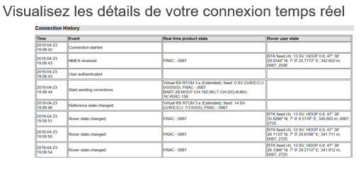
- Your connection history
- The remaining credit on your hourly rate
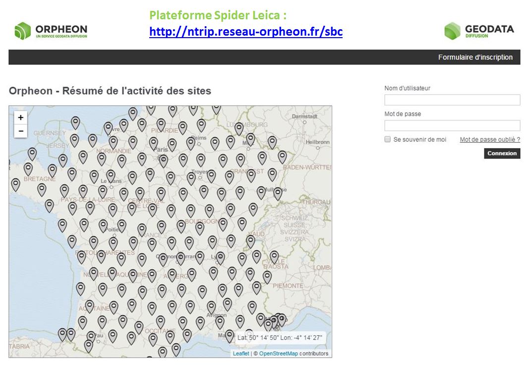
Find your login information and log in using your username and password, on one of the following platforms:
-
Plateforme Spider Leica : http://ntrip.reseau-orpheon.fr/sbc
This approach is part of a desire to improve the quality of our services and simplify our exchanges. We hope that this additional information will satisfy you.
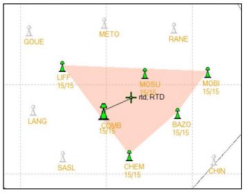
The permanent stations do not have a given radius of action insofar as the calculation is done in a network, with uniform precision at any point in the territory. Concretely, the system uses a set of several stations around you to create a cell, in order to obtain solid and consistent data. Thus, whether you are a few meters or a few kilometers from the nearest station has no impact on the quality of service.
Work in network mode within a cell
When you encounter network connection problems, it is essential to be able to determine the source of these problems, which are generally linked to one of the following two reasons:
Mobile Internet:
Before accessing the servers of the Orphéon network, your mobile must first of all be connected to the Internet in a stable manner. When you launch a connection, you can thus, depending on the behavior of your hardware, determine if the problem is related to the mobile connection when, for example:
- You do not receive any error message, your mobile tries to connect without effect. Your authentication request does not reach the Orpheon servers.
- Connection sessions are short and follow one another. This means that the quality of your mobile internet connection is not good or is not stable.
- On connection reports, the server shows the message: “Connection terminated by rover user”
This can come from the distance with the relay antenna of the telephone operator (Orange, SFR or other). This may be due to the quality of the signal provided by the telephone operator; a too weak or choppy signal or fluctuating latencies (data transfer times). You can try using a SIM card from another operator.
In order to determine what is the level of coverage for your mobile internet access in the area in which you wish to work, there are two official sites
1/ The ARCEP website :
2/ the ANFR website
The Orpheon network :
- You receive error or rejection messages related to your authentication or multiple connections.
- On the Orpheon Smartphone application, several Orpheon reference stations are stopped (in red or blue).
- The Orpheon Smartphone application no longer starts or you cannot reach the Orpheon server web page.
This can be due to several factors:
- Check that your subscription or plan is still active.
- Check that you have not left the restricted area of your Local, Departmental or Regional subscription.
- Check that another mobile is not already connected with your credentials.
- Check that the configuration of your mobile corresponds well with the mount point you have selected.
- Check the configuration concerning the IP address has been correctly filled in with a DNS address and not a fixed IP address such as 69.64.185.131 (Spider) or 69.64.125.240 (TPP).
Find your login information and log in using your username and password, on one of the following platforms:
- Plateforme Spider Leica : http://ntrip.reseau-orpheon.fr/sbc
With your smartphone
To access this information wherever you are, connect by flashing the QR-code below corresponding to the dedicated platform on which your GPS is usually connected:
Leica Spider Platform :

Depending on your work environment and the usual platform on which your GPS is connected. This dedicated platform offers all our customers various services that complete access to your real-time GNSS corrections. It also allows you to freely consult:
-
-
-
- The status of the Orpheon GNSS network
- Your personal information
- The contracts you have entered into
- Your connection history
- The remaining credit on your hourly rate
-
-
Learn more :
Contact our Technical Service who will bring you concrete help and guide you step by step.
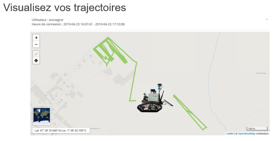
The Orphéon network offers, thanks to its user interface, tools that facilitate your daily work or the development and integration of precision GPS chips in your projects. Check your connections in real time, consult logs or view your trajectories makes your work easier and saves time. but also post-process your work directly online.
Go straight to the point!
Depending on your work environment and the usual platform on which your GPS is connected. This dedicated platform offers all our customers various services that complete access to your real-time GNSS corrections. It also allows you to freely consult:
-
-
-
- The status of the Orpheon GNSS network
- Your personal information
- The contracts you have entered into
- Your connection history
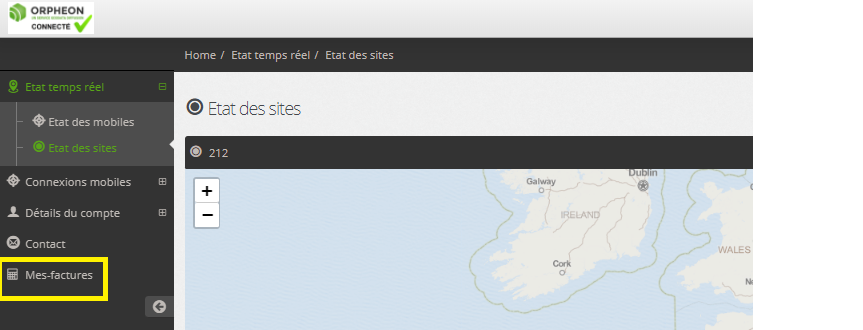
- The history of your e-Invoices*
- The remaining credit on your hourly rate
-
-
History of your e-invoices:
*Available, if you are billed by Geodata Diffusion directly for your subscriptions or your packages and you have accepted the dematerialized billing method (for more details see the dedicated e-invoice page).
Easily find the history of your invoices on your customer area : https://fr.nrtk.eu/SBC/
Log in to your space with your username and password.
Retrouvez vos informations de connexion et connectez-vous à l’aide de votre identifiant et de votre mot de passe, sur l’une des plateformes suivantes :
- Plateforme Spider Leica : http://ntrip.reseau-orpheon.fr/sbc
With your smartphone
To access this information wherever you are, connect by flashing the QR-code below corresponding to the dedicated platform on which your GPS is usually connected:
Leica Spider platform:
This approach is part of a desire to improve the quality of our services and simplify our exchanges. We hope that this additional information will satisfy you.
The mount point allows you to choose the type of data stream that will be exchanged between your hardware and our server, this corresponds both to the language that the hardware will use but also to the method of calculating the positioning that will be used.
The choice of the mounting point therefore depends on your equipment, its brand, its capacities and the choice of the method of calculation of the positioning that you will use. Each manufacturer will favor a type of correction and the flow of data that will optimize the results of your work. For this, some major manufacturers have developed their own data flow that our servers are able to transmit. There are also standardized and normalized data flows common to all equipment and allowing the same performance to be obtained.
On our delivery notes, we suggest one or more mounting points, so that you can configure them corresponding to your equipment, but you are completely free to choose a different mounting point available.
In most cases all equipment allows you to use VRS (Virtual Reference Station) type mounting points
Mount points available for Topography:
- VRS_RTCM-MSM_FULL (Any Full GNSS hardware)
- VRS_RTCM-3.0_GG (All Hardware)
- VRS_CMRx_GG (Trimble Group Hardware)
- i-Max_RTCM-MSM_FULL (Hexagon Full GNSS group hardware)
- i-Max_RTCM-3.0_GG (Hexagon Group Hardware)
Mount points available for Agriculture:
- VRS_RTCM-MSM_FULL (Any Full GNSS hardware)
- VRS_RTCM-3.0_GG (All Hardware)
- i-Max_RTCM-MSM_FULL (Hardware with Novatel Full GNSS card)
- i-Max_RTCM-3.0_GG (Hardware with Novatel card)
- Plus_pres_RTCM3_GG (All hardware single station)
- Plus_pres_CMRPlus_GG (Trimble group hardware mono station)
In case of wrong choice of mounting point:
- You will not be able to connect to our servers and therefore you will not be able to obtain a correction. You will therefore not have the expected precision. Your position will remain in natural or floating mode (without correction) the material failing to fix the ambiguities. On the Smartphone application, the symbol locating your equipment will be in red.
- You will manage to connect to our servers but the corrections you get will be misinterpreted by your equipment. You will therefore not have the expected precision. On the Smartphone application, your position will apparently be fixed (with correction), the symbol locating your equipment will be in green.
It is therefore essential that the configuration of your equipment is checked to match the correction mode expected and configured on your mobile with the corrections delivered by our servers according to the mounting point you have selected.
If you change the mounting point, check that you have also adapted the configuration of your equipment so that the 2 correspond well.
The right mounting point:
Learn more :
Contact our Technical Service who will bring you concrete help and guide you step by step.
The mount point allows you to choose the type of data stream that will be exchanged between your hardware and our server, this corresponds both to the language that the hardware will use but also to the method of calculating the positioning that will be used.
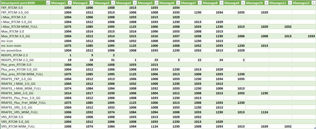
Here is the list of RTCM messages used for each mount point for port 8500 (all applications except agriculture. For agriculture see list of RTCM messages for port 7500).
The mount point allows you to choose the type of data stream that will be exchanged between your hardware and our server, this corresponds both to the language that the hardware will use but also to the method of calculating the positioning that will be used.
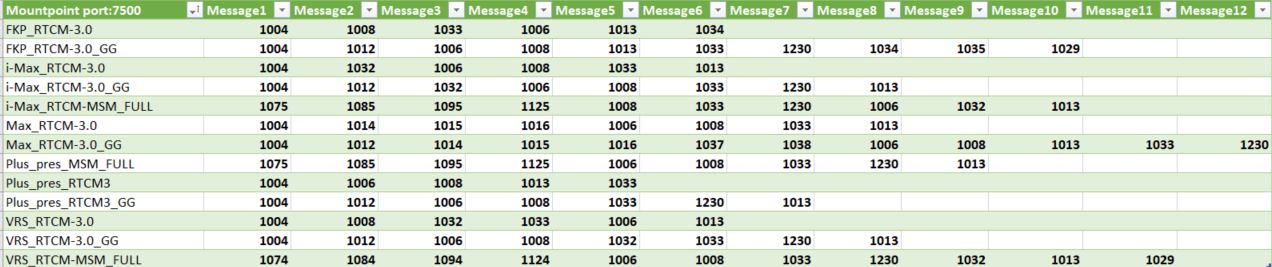
Here is the list of RTCM messages used for each mount point of port 7500 (Agriculture)
The data transmission format is determined by the choice of mount point
The mount point allows you to choose the type of data stream that will be exchanged between your hardware and our server, this corresponds both to the language that the hardware will use but also to the method of calculating the positioning that will be used.
The choice of the mounting point therefore depends on your equipment, its brand, its capacities and the choice of the method of calculation of the positioning that you will use. Each manufacturer will favor a type of correction and the flow of data that will optimize the results of your work. For this, some major manufacturers have developed their own data flow that our servers are able to transmit. There are also standardized and normalized data flows common to all equipment and allowing the same performance to be obtained.
On our delivery notes, we suggest one or more mounting points, so that you can configure them corresponding to your equipment, but you are completely free to choose a different mounting point available.
In most cases all equipment allows you to use VRS (Virtual Reference Station) type mounting points
RTCM-2.x format (DGPS)
This message is the most common way to send DGPS style code corrections for GPS.
Format RTCM-3.1 ( RTK GPS Glonass)
RTCM versions 3.0 and 3.1 focus on optimizing bandwidth usage [6], higher integrity [7] and managing RTK networks
Format RTCM-3.x MSM (RTK Full GNSS)
Message formats were previously limited to the L1 and L2 bands and a single signal per band, which is why it became necessary to use a new universal real-time data format: the MSM (for Multiple Signal Message) which is the new concept of RTCM-3 key allowing to present all GNSS observation data in generic form.
The RTCM-3 MSM standard thus ensures data interoperability with all compatible GNSS receivers by transmitting standardized observations of GPS + Glonass + Galileo + Beidou signals for all L1/L2 and L5 frequencies.
Mount points available for Topography:
- VRS_RTCM-MSM_FULL (Any Full GNSS hardware)
- VRS_RTCM-3.0_GG (All Hardware)
- VRS_CMRx_GG (Trimble Group Hardware)
- i-Max_RTCM-MSM_FULL (Hexagon Full GNSS group hardware)
- i-Max_RTCM-3.0_GG (Hexagon Group Hardware)
Mount points available for Agriculture:
- VRS_RTCM-MSM_FULL (Any Full GNSS hardware)
- VRS_RTCM-3.0_GG (All Hardware)
- i-Max_RTCM-MSM_FULL (Hardware with Novatel Full GNSS card)
- i-Max_RTCM-3.0_GG (Hardware with Novatel card)
- Plus_pres_RTCM3_GG (All hardware single station)
- Plus_pres_CMRPlus_GG (Trimble group hardware mono station)
In case of wrong choice of mounting point:
- You will not be able to connect to our servers and therefore you will not be able to obtain a correction. You will therefore not have the expected precision. Your position will remain in natural or floating mode (without correction) the material failing to fix the ambiguities. On the Smartphone application, the symbol locating your equipment will be in red.
- You will manage to connect to our servers but the corrections you get will be misinterpreted by your equipment. You will therefore not have the expected precision. On the Smartphone application, your position will apparently be fixed (with correction), the symbol locating your equipment will be in green.
It is therefore essential that the configuration of your equipment is checked to match the correction mode expected and configured on your mobile with the corrections delivered by our servers according to the mounting point you have selected.
If you change the mounting point, check that you have also adapted the configuration of your equipment so that the 2 correspond well.
The right mounting point:
When the correct mounting point is selected, the hardware fixes ambiguities very quickly, on the smartphone application the symbol locating your equipment will be a green cross in network mode or a blue cross for the mono-station.
In addition, our teams are on hand to help you check and adjust your receiver.
Learn more :
Contact our Technical Service who will bring you concrete help and guide you step by step.
In case of wrong choice of mounting point:
- You will not be able to connect to our servers and therefore you will not be able to obtain a correction. You will therefore not have the expected precision. Your position will remain in natural or floating mode (without correction) the material failing to fix the ambiguities. On the Smartphone application, the symbol locating your equipment will be in red.
- You will manage to connect to our servers but the corrections you get will be misinterpreted by your equipment. You will therefore not have the expected precision. On the Smartphone application, your position will apparently be fixed (with correction), the symbol locating your equipment will be in green.
It is therefore essential that the configuration of your equipment is checked to match the correction mode expected and configured on your mobile with the corrections delivered by our servers according to the mounting point you have selected.
If you change the mounting point, check that you have also adapted the configuration of your equipment so that the 2 correspond well.
Self-check recommendations
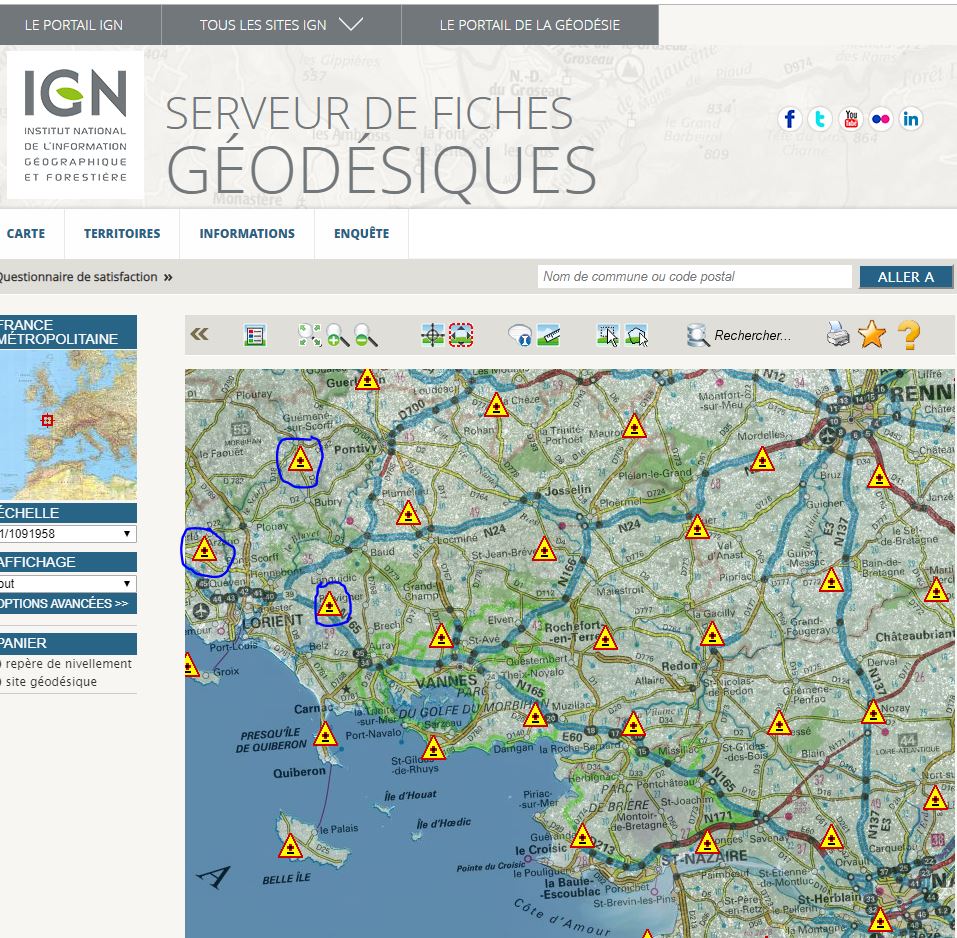
In our recommendations for field phase measurement, we recommend the occupation of all known points in coordinates (RBF, NGF).
To know these points near your site, the IGN provides you with the location of its terminals as well as a wealth of very useful information for the whole of France, Access to the IGN website (click to open the link )
- Control of measurement equipment (Firmware version of GNSS equipment, status of the rod, of the bubble, compliant configuration and configuration)
- Turn on the mobile and stand on a clear point
- Ensure good internet connection and service stability
- Connect to real-time correction services
- Start a first initialization session (8 minutes without cycle jumps for 6 satellites being one fairly widespread minimum recommended value) for subsequent fixing of integer ambiguities
- Centre, bubble, check antenna height and stability
- Perform measurement work while ensuring GNSS measurement conditions: sufficient number of satellites, GDOP < 3 – 4, SNR > 50 (on L1) or 40 (on L2)
- In the event of a cut warning by the receiver or in the event of lifting in a place prone to cuts signal (near trees, buildings, etc.), redo an initialization session
- Reoccupy the first point at the end of the lift
- Reoccupy the important points at least once after at least 20 minutes (see control sheet)
- Occupation of all known points in coordinates (RBF, NGF) (see check sheet)
You will also find an article published in XYZ on the subject Real-time static positioning by “filtering and averaging NRTK positions” , Lire l’article
Learn more :
Contact our Technical Service who will bring you concrete help and guide you step by step.
You have an active subscription and are connecting to our Trimble Platform Pivot (TPP).
The shutdown of this platform was scheduled for the end of the first quarter of 2020.
For several weeks, in conjunction with our distributors, we have been gradually transferring subscribers to the SpiderNet platform, our first line of calculations.
You can find here the information of this quick operation which mainly consists of modifying some of the connection parameters of your receiver.
Here are the parameters to enter:
IP or DNS address: Ntrip.reseau-orpheon.fr
Port: 8500
We suggest the following mounting points:
VRS_RTCM-3.0_GG
VRS_RTCM-MSM_FULL
Depending on your hardware. Attention, make sure that the setting is consistent with the format of the messages (do not select CMRx on your hardware)
In case of concerns or questions
We have also created a form below to facilitate the processing of requests that come directly to our technical support team.
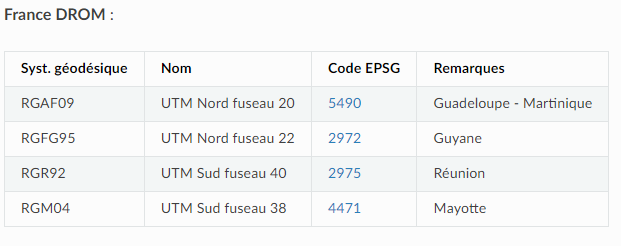
RGAF09 as standard on the Orphéon network
As of Monday, December 16, 2019 at 06:30 UTC the Orpheon network uses RGAF91
the new official national reference system for the West Indies: the WGS84-RGAF09.
The decree of March 5, 2019 formalizes the legal and precise national coordinate reference system for the West Indies, WGS84-RGAF09.
With the officialization of the long-awaited RGAF09 and the improvement it presents the Orpheon network has been updated to offer the new official coordinate system for the Antilles.
Directly in RGAF91
The change is direct without user intervention.
No modification is therefore necessary for customers using the Orphéon network, as soon as they connect to the network, the coordinates will be expressed directly in the new official reference WGS84-RGAF09.
The RAAF91 – Always Available
However, for more than 10 years the Orpheon network has been working in the national coordinate reference system WGS84-RAAF91 which will therefore remain valid for another 3 years. Professional network users have become accustomed to using Orpheon and have configured their equipment and their work accordingly. We keep this possibility not to suddenly upset the work of many professionals.
Keep the old reference system RRAF91
Some network users may still need to work with the old RRAF91 reference system for a while longer, to complete a job or resume an old survey without having to do any prior conversion.
We thought of them:
We provide you with new mounting points allowing you to work in the old reference system.
Reverting to RRAF91 will require setting up your hardware by selecting one of the new mount points that matches your setup.
-
-
- RRAF91_i-MAX_3.0_GG
- RRAF91_i-MAX_MSM_FULL
- RRAF91_VRS_3.0_GG
- RRAF91_VRS_MSM_FULL
- RRAF91_MAX_3.0_GG
- RRAF91_FKP_3.0_GG
- RRAF91_Plus-Pres_3.0_GG
- RRAF91_Plus-Pres_MSM_FULL
-
To avoid confusion, note that the names of these new mount points always begin with RRAF91.
Switch from RRAF91 to RGAF09?
Coordinate transformation:
It is possible to use our online transformation tool or IGN provides the transformation parameters from local systems and WGS84-RRAF to the RGAF09 system as well as a CIRCE tool.
Helmert parameters necessary for the transformation of coordinates expressed in old systems to RGAF09.
IGN provides the parameters needed to transform RRAF91 coordinates into RGAF09 and vice versa. It is therefore possible to indirectly link GNSS work carried out in other systems to the RRAF91 reference.
The table below lists the values of these parameters. Note in particular the values of the translations between the RRAF91 and the RGAF09 which differ up to 10 m depending on the area concerned. This testifies to the heterogeneity of the inter-island RRAF91.
| Zone | Martinique | Guadeloupe | Guadeloupe | Martinique | Guadeloupe | Guadeloupe |
| Système de départ | Fort Desaix | Saint-Anne | Fort Marigot | RRAF91 | RRAF91 | RRAF91 |
| Système d’arrivée | RGAF09 | RGAF09 | RGAF09 | RGAF09 | RGAF09 | RGAF09 |
| TX (m) | 127.744 | -471.060 | 151.613 | 0.7696 | 1.2239 | 14.6642 |
| TY (m) | 547.069 | -3.212 | 253.832 | -0.8692 | 2.4156 | 5.2493 |
| TZ (m) | 118.359 | -305.843 | -429.084 | -12.0631 | -1.7598 | 0.1981 |
| RX (arcsec) | -3.1116 | 0.4752 | -0.0506 | -0.32511 | 0.03800 | -0.06838 |
| RY (arcsec) | 4.9509 | -0.9978 | 0.0958 | -0.21041 | -0.16101 | 0.09141 |
| RZ (arcsec) | -0.8837 | 0.2069 | -0.5974 | -0.02390 | -0.04925 | -0.58131 |
| D (ppm) | 14.1012 | 2.1353 | -0.3971 | 0.2829 | 0.2387 | -0.4067 |
Tab. Helmert parameters between Martinique/Guadeloupe local systems and RGAF09 and between RRAF91 and RGAF09.
These transformation parameters are included in the IGN software Circé (downloadable from the IGN website
A new format for Full GNSS
Message formats were previously limited to the L1 and L2 bands and a single signal per band, which is why it became necessary to use a new universal real-time data format: the MSM (for Multiple Signal Message) which is the new concept of RTCM-3 key allowing to present all GNSS observation data in generic form.
Format RTCM-3.x MSM (RTK Full GNSS)
The RTCM-3 MSM standard thus ensures data interoperability with all compatible GNSS receivers by transmitting standardized observations of GPS + Glonass + Galileo + Beidou signals for all L1/L2 and L5 frequencies.
The data transmission format is determined by the choice of mount point
The mount point allows you to choose the type of data stream that will be exchanged between your hardware and our server, this corresponds both to the language that the hardware will use but also to the method of calculating the positioning that will be used.
The choice of the mounting point therefore depends on your equipment, its brand, its capacities and the choice of the method of calculation of the positioning that you will use. Each manufacturer will favor a type of correction and the flow of data that will optimize the results of your work. For this, some major manufacturers have developed their own data flow that our servers are able to transmit. There are also standardized and normalized data flows common to all equipment and allowing the same performance to be obtained.
On our delivery notes, we suggest one or more mounting points, so that you can configure them corresponding to your equipment, but you are completely free to choose a different mounting point available.
In most cases all equipment allows you to use VRS (Virtual Reference Station) type mounting points
Format RTCM-2.x (DGPS)
This message is the most common way to send DGPS style code corrections for GPS.
Format RTCM-3.1 ( RTK GPS Glonass)
RTCM versions 3.0 and 3.1 focus on optimizing bandwidth usage [6], higher integrity [7] and managing RTK networks
version 3.x uses a variable-length message format and a single 24-bit cyclic redundancy check (CRC) over the entire message, as opposed to 6-bit parity for each 30-bit word. Like previous versions, the message format begins with an 8-bit extended preamble, followed by a 6-bit reserved area, and then a 10-bit message length that allows up to 1024 bytes of data. The message, each with its privately defined header and data, follows the header and is then limited by the CRC. The saving of data, especially in the case of RTK, is significant, an RTK version 3 correction set is generally half as long as version 2.
Local coordinate systems
As with GPS coordinates, local coordinates or coordinates used in a given country’s mapping system are based on a local ellipsoid, intended to best match the geoid in the area concerned. As a rule, these coordinates are projected onto a plane so as to obtain planar coordinates.
Each country has therefore defined a reference system based on a local ellipsoid to meet its own needs. When using GPS, the calculated position coordinates are based on the WGS84 ellipsoid. Ordinarily, existing coordinates are expressed in a local coordinate system, so the GPS coordinates must be transformed into this local system.
All altitudes measured by GPS are relative to the surface of the WGS84 ellipsoid. These are thus ellipsoidal altitudes. The existing altitudes are generally orthometric altitudes referred to the mean sea level. The mean sea level corresponds to a surface called the geoid, which can be defined as an equipotential surface, that is to say that the value of gravity is constant at all points on this surface. The geoid is irregular in shape and does not correspond to any ellipsoid. The density terrestrial (the distribution of masses) however exerts an influence on the geoid, the level of the latter being higher in very dense regions and lower in low density regions.
This problem is solved by using geoid models to convert ellipsoidal heights to orthometric heights. In less rugged areas, the geoid can be considered constant. In such regions, the use of certain transformation techniques can lead to the production of a height model, the geoid heights can then be interpolated from existing data.
Lambert’s projection
The Lambert projection is also a conformal projection, based on a secant cone with the spheroid. It is ideal for small circular countries, islands and polar regions.
The Lambert projection is defined by:
• false East and false North values
• the latitude of the origin
• the central meridian
• the latitude of the 1st parallel of contact
• the latitude of the 2nd parallel of contact
The False East and False North values are defined so that the origin of the projected system is in the lower left corner as required by convention. This also avoids the presence of negative coordinates. The latitude of the origin defines the latitude of the origin of the projection. The central meridian defines the direction of the north of the grid and the longitude of the center of the projection.
The latitude of the 1st parallel of contact defines the latitude of the first intersection of the cone and the spheroid, in which the scale is preserved. The latitude of the 2nd parallel of contact defines the latitude of the second intersection of the cone and the spheroid, in which the scale is also retained. The scale is reduced in the area between the two contact parallels and increases outside of it. It is conserved on each of the two contact parallels. The scale does not vary in the east-west direction.
List of EPSG codes
EPSG (European Petroleum Survey Group) codes are a list of projection georeferenced coordinate systems used by many GIS software packages.
These codes are notably used in the standards of the OGC (Open Geospatial Consortium).
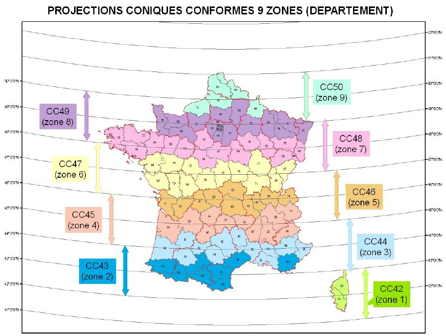
EPSG: Division of Lambert zones (V1)
EPSG: Division of the 9 zones of the Lambert 93 (V2)
In the configuration of your equipment which will guide your choice of mounting point, the choice of the type of corrections will depend on your equipment, the measurements you are going to perform and the availability of services.
MAC
Initiated by Leica Geosystelms and GEO++ in 2001, the first NRTK standard for network message correction that would overcome the problems of the various existing approaches. Concept based on the notion of master and mobile (Master Auxiliary Concept) allowing the Mobile to receive raw observation data from the nearest Master station in order to perform its correction calculations.
MAX
This Leica Geosystems format is based on the principle of using a cell of several reference stations around the rover with a reference station (the closest). MAX corrections contain all of the cell’s correction information and provide the maximum level of accuracy and reliability for the rover.
These corrections optimize the bandwidth needed to transmit the corrections.
FKP
The oldest FKP method, (Flächen-Korrektur-Parameter) developed by Geo++, consists of the principle of transmissions of a model of errors calculated for the place where the mobile is specifically located. Subsequently, the rover calculates the corrections itself in the same way as in VRS. In addition the correction of a physical reference station is used in combination with the FKPs to calculate the individualized corrections for the position of the mobile.
FKP corrections are transmitted in RTCM 2.3 format. This method which provides the mobile with more information is bandwidth intensive and requires stable communication quality.
i-MAX
Introduced by Leica Geosystems the RTK network corrections are based on the position of the rover are calculated from information relating to a virtual master station created by calculations in close proximity to the rover in order to reduce the length of the baseline and present a level of lower error. The position of the master station can change to follow the movements of the mobile.
Full GNSS compatible corrections transmitted in RTCM-3 MSM format
VRS
With the Virtual Reference Station, a concept introduced by Trimble, the rover interprets and uses network-correction data from a virtual base as if it were operating with a single physical base station on a very short baseline, this which dramatically increases RTK performance. However, it does not create a virtual vector.
Full GNSS compatible corrections transmitted in RTCM-3 MSM format
Format RTCM-2.x (DGPS)
This message is the most common way to send DGPS style code corrections for GPS or FKP
Format RTCM-3.1 ( RTK GPS Glonass)
RTCM versions 3.0 and 3.1 focus on optimizing bandwidth usage [6], higher integrity [7] and managing RTK networks
Format RTCM-3.x MSM (RTK Full GNSS)
The RTCM-3 MSM standard thus ensures data interoperability with all compatible GNSS receivers by transmitting standardized observations of GPS + Glonass + Galileo + Beidou signals for all L1/L2 and L5 frequencies.
Message formats were previously limited to the L1 and L2 bands and a single signal per band, which is why it became necessary to use a new universal real-time data format: the MSM (for Multiple Signal Message) which is the new concept of RTCM-3 key allowing to present all GNSS observation data in generic form.
We have replaced IP addresses with DNS (Domain Name System) addresses. This configuration is now the standard format for setting up on GPS receivers.
So when we switch to our backup system, each user doesn’t have to change their receiver settings, everything is transparent and smooth.
Two DNS are provided to replace the IP address depending on the correction platform used for your equipment:
- Spider Leica platform: ntrip.reseau-orpheon.fr
or - Trimble Pivot Platform: ntrip2.reseau-orpheon.fr
Important:
Since January 2017 you can find this information on your delivery note with all the connection parameters
Notes:
Customers who decide to keep fixed IP addresses will not be able to automatically switch to the backup system in the event of maintenance or a problem on the main servers. We therefore strongly advise not to keep fixed IP addresses. In addition, we decline all responsibility in the event that a customer has kept an IP address in the configuration of his equipment and if he is unable to connect to our services.
We have replaced IP addresses with DNS (Domain Name System) addresses. This configuration is now the standard configuration format to be performed on GPS receivers.
So when we switch to our backup system in the event of a problem on the main server, each user is not obliged to change the parameters of their receiver, everything is transparent and fluid. In a few moments, the stream of corrections then comes from the backup server.
Here is the DNS address used for your equipment:
- DNS Spider Leica Platform: ntrip.reseau-orpheon.fr
Important :
Since January 2017 you can find this information on your delivery note with all the connection parameters
Note :
Customers who decide to keep fixed IP addresses will not be able to automatically switch to the backup system in the event of maintenance or a problem on the main servers. We therefore strongly advise not to keep fixed IP addresses. In addition, we decline all responsibility in the event that a customer has kept an IP address in the configuration of his equipment and if he is unable to connect to our services.
In case your equipment does not accept a DNS address (very rare) here is the IP address: 69.64.185.131 – Warning: the use of this fixed IP address does not allow you to benefit from the automatic failover on the server of rescue.
Find below the various information for setting up the APNs, identifiers and passwords so that your equipment can connect to the internet using the SFR or Orange SIM card that you ordered from Géodata Diffusion.
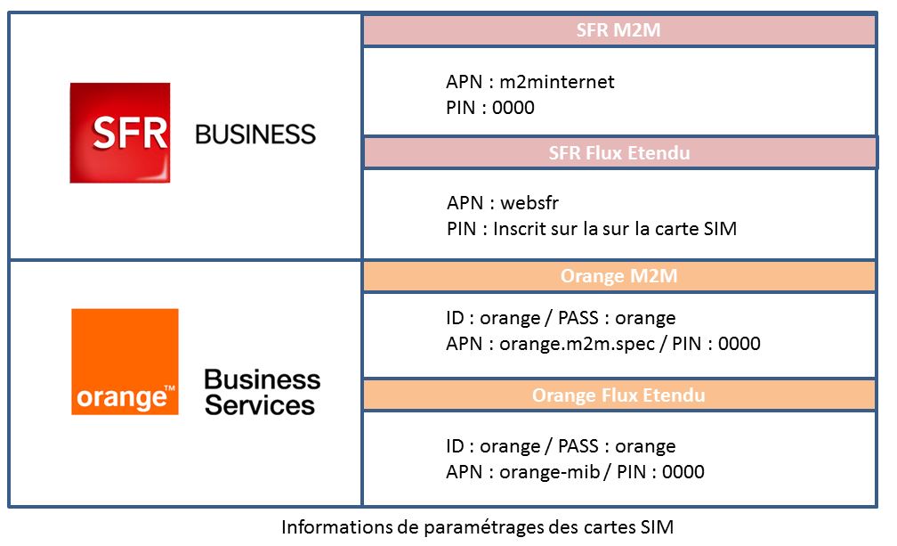
Enter these parameters in your equipment in the communication part (GSM-GPRS refer to the technical documentation of your equipment).
You will then have to configure the parameters for the connection to the Orpheon network with your username and password (see delivery note)
M2M Machine-To-Machine SIM Cards
- Gprs/edge/3G
- Dedicated to the Orpheon connection
- Specialized in data exchange
- Priority Pro communication for more availability
- Competitive standard rates
Carte Sim Flux Eténdu
- Gprs/edge/3G/4G
- Compatible with all your business applications
- An extended volume of Data
- Specialized in data exchange
- Priority Pro communication for more availability
- Competitive standard rates
Learn more :
Discover : Choice of SIM cards
Below you will find information that we think will be useful for the use of the SIM cards of the various operators that we supply.
Important: depending on the type of card or the age of the contract, the Roaming option must be activated
For many years at Geodata Diffusion we have been providing our customers with SIM cards. Since then, the legislation and invoicing rules for the Roaming Europe option have changed a great deal. Some of the cards delivered before these changes did not have the Europe option activated because at the time this option was chargeable and led to significant additional costs for exceeding the package. Today these options have become free and no longer generate unpleasant surprises.
In general, roaming at national rates, which allows you to use your mobile plan from abroad without being surcharged, only applies to occasional use. Your consumption from France must be the majority.
Could I use my mobile Internet volume in the European zone?
You can use your monthly mobile Internet volume both in the European zone and in mainland France(1).
For example, if your package includes 5 GB of internet and you use 2 GB while working in Germany, you will have 3 GB of your package left when you return to France. If your mobile Internet volume runs out, one of the following pricing conditions will apply until the date your plan is reset (depending on the mobile offer you have):
– reduced flow,
– blocking your blocked mobile internet,
– off-package at the rate applicable in mainland France.
Access to the Orpheon network
It should also be noted that mobile Internet access abroad does not systematically give access to the Orphéon network. For this, reference should be made to the network coverage area (Metropolitan France and the West Indies).
To simplify, the Roaming Europe option is mainly useful for our customers working on the edge of borders, when their equipment “terminal” on a relay in the neighboring country. For remote countries, it will be necessary to take out an RTK subscription in the country concerned (example in England, Poland, etc.). We also recommend that you take out an RTK SmartNet subscription.
For Orange SIM cards:
Since October 1, 2019, automatically and without changing the offer: you have nothing to do!
These changes apply automatically and free of charge to your package.
The destinations included in your package for your trips in the European zone
Europe
Azores (the), Aland (islands), Germany, Austria, Balearic Islands, Belgium, Bulgaria, Canaries (islands), Cyprus, Corfu (island), Crete, Cyclades (the), Croatia, Denmark, Spain, Estonia, Faroe (islands ), Finland, Gibraltar, Greece, Guernsey, Hungary, Ireland, Iceland, Italy, Jersey, Latvia, Liechtenstein, Lithuania, Luxembourg, Madeira, Malta, Man (Island), Norway, Netherlands, Poland, Portugal, Czech Republic , Rhodes (island of), Romania, United Kingdom, San Marino, Sardinia, Sicily, Slovakia, Slovenia, Sweden, Vatican
DOM
Guadeloupe, French Guyana, Martinique, Réunion and certain overseas communities: Mayotte, Saint-Barthélemy, Saint-Martin (island of), Saint-Pierre-et-Miquelon
Switzerland/Andorra
For SFR SIM cards :
Depending on the SFR offer to which you have subscribed, it is possible to have an internet connection from the European Union and the overseas departments at no additional cost. We still invite you to check the conditions of your offer (excluding packages with blocking option and La Carte offers).
If you are in the European Union or in the overseas departments, mobile internet connections are included in your SFR package. Be sure, before your departure or during your departure, to confirm the conditions of your offer.
Find below the countries included in each group for SFR Mobile customers.
Europe: Azores, Åland, Germany, Andorra, England, Austria, Balearic Islands, Belgium, Bulgaria, Canary Islands, Cyprus, Corfu, Crete, Croatia, Cyclades, Denmark, Scotland, Spain, Estonia, Finland, Gibraltar, Greece, Guernsey, Faroe Islands, Hungary, Ireland, Northern Ireland, Iceland, Italy, Jersey (Island of), Latvia, Liechtenstein, Lithuania, Luxembourg, Madeira, Man (Island), Malta, Norway, Netherlands, Wales, Poland , Portugal, Rhodes (Islands of), Romania, San Marino, Sardinia, Sicily, Slovakia, Slovenia, Sweden, Switzerland, Czech Republic, Vatican.
The overseas departments: Guadeloupe, French Guiana, Martinique, Réunion, St Barthélemy, St Martin (French West Indies), St Pierre and Miquelon, Mayotte, La Désirade, Marie Galante, Saintes Islands.
For Multi-Operator SIM cards :
If you are in the European Union or the French overseas departments, mobile internet connections are included in your Multi-Operator plan. Be sure, before your departure or during your departure, to confirm the conditions of your offer.
Find below the countries included in each group.
Europe: Azores, Åland, Germany, Andorra, England, Austria, Balearic Islands, Belgium, Bulgaria, Canary Islands, Cyprus, Corfu, Crete, Croatia, Cyclades, Denmark, Scotland, Spain, Estonia, Finland, Gibraltar, Greece, Guernsey, Faroe Islands, Hungary, Ireland, Northern Ireland, Iceland, Italy, Jersey (Island of), Latvia, Liechtenstein, Lithuania, Luxembourg, Madeira, Man (Island), Malta, Monaco, Norway, Netherlands, Wales , Poland, Portugal, Rhodes (Islands of), Romania, San Marino, Sardinia, Sicily, Slovakia, Slovenia, Sweden, Switzerland, Czech Republic, Vatican.
The overseas departments: Guadeloupe, French Guiana, Martinique, Réunion, St Barthélemy, St Martin (French West Indies), St Pierre and Miquelon, Mayotte, La Désirade, Marie Galante, Saintes Islands.
Depending on your work environment and the usual platform on which your GPS is connected. This dedicated platform offers all our customers various services that complete access to your real-time GNSS corrections. It also allows you to freely consult:
- The status of the Orpheon GNSS network
- Your personal information
- The contracts you have entered into
- Your connection history
- The remaining credit on your hourly rate
Find your login information and log in using your username and password, on one of the following platforms:
- Plateforme Spider Leica : http://ntrip.reseau-orpheon.fr/sbc
With your smartphone
To access this information wherever you are, connect by flashing the QR-code below corresponding to the dedicated platform on which your GPS is usually connected:
Application download:
Click on the image below to access more information about our Smartphone applications and its features.
This approach is part of a desire to improve the quality of our services and simplify our exchanges. We hope that this additional information will satisfy you.
As a reminder, in order to be able to position itself within a few centimeters, a GPS/GNSS rover must be able to:
- perform noise-free phase measurements on at least 5 satellites well distributed in space,
- and receive differential corrections on these same 5 satellites.
Adding 2 constellations of additional Galileo and BeiDou satellites to those of the GPS and Glonass constellation thus makes it possible to increase the possibility of receiving a sufficient number of signals and of better quality, especially in difficult places.
Indeed, in an urban environment, the walls of buildings or trees create masks which limit the number of visible satellites but also create “echoes” (multipath) which disturb the calculation of the positioning of the equipment. The number of visible satellites has therefore always been an important issue for quality positioning.
How does it benefit you on a daily basis?
100% more satellites
The addition of the Galileo and BeiDou satellites to the GPS and GLONASS satellites significantly increases the number of satellites that can be observed simultaneously by a GNSS antenna.
The addition of the GALILEO and BeiDou constellations thanks to the Orphéon network is not a simple gadget, but the assurance of better daily productivity in the field.
Indeed, you can now permanently count on the constant availability of at least 6 additional satellites to bring you real advantages:
Improved positioning quality
- More satellites available to calculate its position
- Precise positioning even in difficult environments (urban canyons for example or under a canopy)
- Improved positioning reliability
- Shorter fixing time
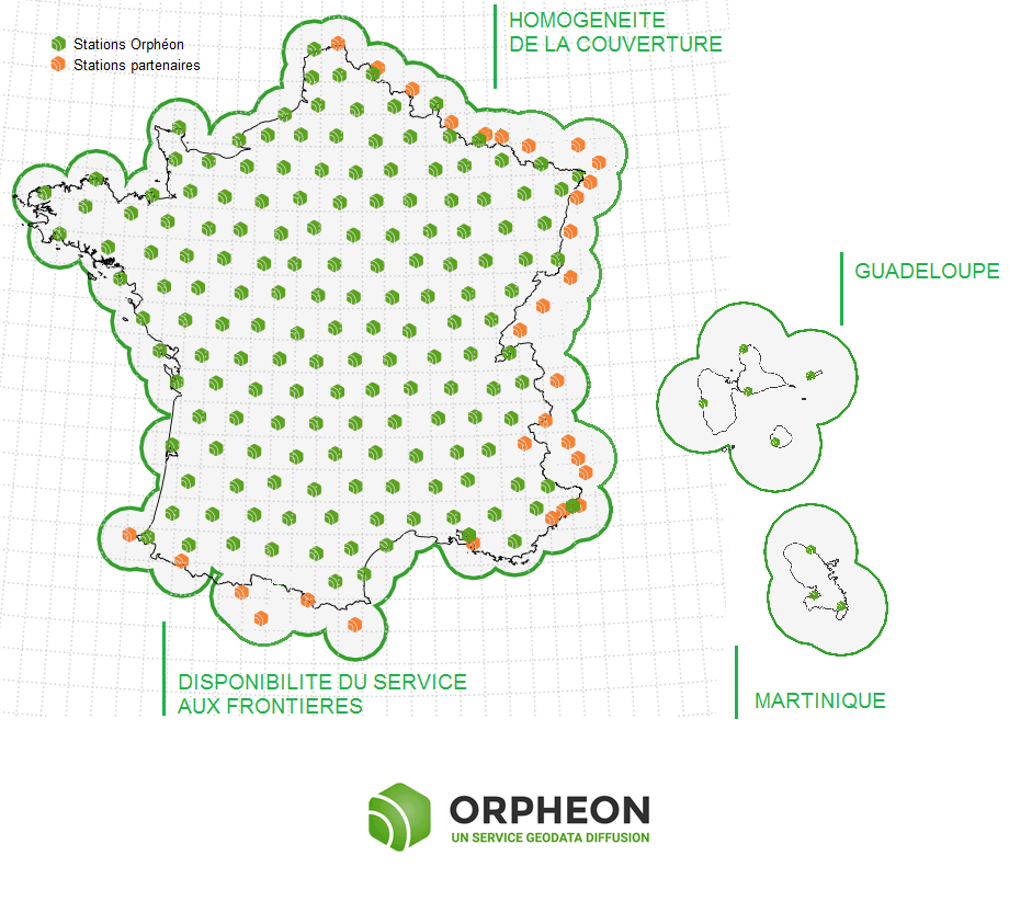
The densest and most regular coverage area in France
A multi-constellation network
With its 215 stations in mainland France, all Full GNSS: GPS, GLONASS, Galileo and BeiDou with a unique presence in the French West Indies.

Orphéon is the first French multi-constellation network in France.
Learn more: :
See the page : Work in difficult places
Contact our Technical Service who will bring you concrete help and guide you step by step.
Constellations already operational today :
05/11/2017
For GALILEO,
There are currently between 4 and 5 functional satellites which are permanently available for your positioning and the FULL GNSS corrections of the network.

The only Galileo corrections already available in France
Of course, the European system, which today has 16 satellites in orbit, will continue to develop and expand with the forthcoming launch of 4 new satellites, but their number already makes it possible to make a difference and to work in better conditions.
For BeiDou,
There are also between 1 and 4 satellites permanently available for your positioning and the FULL GNSS corrections of the network.
Multi-frequency L1/L2 and L5
Based on L1 and L5 frequencies emitted by satellites to make positioning more resistant to interference and signal reflections, especially in an urban environment.
Everything has been thought out to allow you to benefit from increased productivity.
- Centimeter accuracy corrections for GPS GNSS
- Use of L1/L2 and L5 frequencies
- Real time, very fast convergence time
- A dense and homogeneous RTK network
- A regular and geometric implantation on the whole territory
- An infrastructure designed for service performance
- Very secure facilities
- National and West Indies coverage
- A reference for professionals
- Accuracy, Stability, Availability, Repeatability
- Increasingly varied applications
For you, in the field 6 additional satellites,
Sur le terrain, vous pouvez donc compter en permanence sur une disponibilité constante d’au moins 6 satellites supplémentaires.
Le cumule de ces 2 constellations supplémentaires font aujourd’hui une réelle différence pour votre productivité.
Il n’est donc pas besoin d’attendre 2020 pour tirer le meilleur partie de vos équipements Full GNSS.
Profitez dès à présent des corrections FULL GNSS disponibles sur la totalité du territoire et aux Antilles françaises.
How to take advantage of the new Full GNSS services?
Already subscribed?
Connect today to our real-time services from your GNSS-compatible mobile with your usual user connection parameters (username and password) and select one of our Full GNSS mount points stamped “FULL”.
Settings :
- DNS: ntrip.reseau-orpheon.fr
- Port: 8500
- Mount point*: VRS_RTCM-MSM_FULL or i-Max_RTCM-MSM_FULL
* choice depending on your equipment
Contact our Technical Service who will bring you concrete help and guide you step by step.
New RTMC-3 MSM data format
Message formats were previously limited to the L1 and L2 bands and a single signal per band, which is why it became necessary to use a new universal real-time data format: the MSM (for Multiple Signal Message) which is the new concept of RTCM-3 key allowing to present all GNSS observation data in generic form.
The RTCM-3 MSM standard thus ensures data interoperability with all compatible GNSS receivers by transmitting standardized observations of GPS + Glonass + Galileo + Beidou signals for all L1/L2 and L5 frequencies.
Antenna and Computing Engine
To be able to use the signals from the different constellations, the receiving antenna and the calculation engine must each be compatible with these GPS, Glonass, Galileo and Beidou constellations in order to be able to take their signals into account to deliver a position.
Multi-frequency L1/L2 and L5
Based on the L1 and L5 frequencies emitted by the satellites in order to make positioning more resistant to interference and signal reflections, especially in an urban environment.
Options and Licenses
Many equipment of all brands today are compatible with all of these signals, options and licenses can be acquired and activated to be able to use them. It is often possible to activate these options and licenses to upgrade your equipment now and benefit from the best positioning services.
Depending on your specialty, contact your usual distributor without hesitation (Find your Orpheon distributor), he will know, better than anyone, how to answer you and support you in your projects.
The calculation is done in the network and is not dependent on a station. The service therefore continues to operate and to provide reliable data. To simplify, when a station is temporarily deactivated (for maintenance or for breakdown), the calculation system replaces it with another, located in the same area. permanent stations Orphéon has been designed in such a way that several stations can always take over from a deactivated station.
The geometric regularity of our layouts
The Orphéon network has 215 stations in mainland France, all Full GNSS, i.e.: GPS, GLONASS, Galileo and BeiDou, as well as a historical presence in the French West Indies.
The dense network of permanent stations is arranged regularly every 60 km. Each link in the Orphéon infrastructure has been designed to offer a high-precision RTK correction service available in all circumstances. Border areas are complemented by our partnership agreements within Europe.
Click on the interactive map of the Orphéon network
-
A very regular presence, without compromise and without equivalent in France.
- The careful choice of layout for each of our 195 reference stations creates a linear and regular geometric mesh. Territory coverage is uniform wherever you are.With the Orphéon network, you work with identical precision throughout the territory thanks to a uniform distribution of stations over all the areas covered, whatever your position, the distance from the nearest reference station is never more than 30 km.The Orphéon network thus stands out significantly from its competitors who are multiplying the number of reference stations because of their disorderly location on the territory and whose coverage is losing homogeneity, sometimes leaving very large distances in the meshes of their network.
-
A regular and homogeneous layout
Coverage area
The position of the mobile GPS sent to the server must imperatively be located in the network coverage area but also in the restricted area stipulated when subscribing to the service.
Outside the coverage area of the Orpheon network, the server is not able to provide the corresponding corrections. Our coverage area is defined by the position of our permanent observation stations.
Pay attention to the geographical restriction of your subscription, the server will end the connection and add an error message to the connection log (see Customer Area)
If the mobile GPS returns a position outside the subscription zone
- National: no restrictions
Regional: the administrative region stipulated during the subscription (or 4 contiguous departments)
Departmental: the administrative department stipulated during the subscription
Sending a GGA-type NMEA frame
When connecting, it is important to send a GPGGA-type NMEA frame with the position of the mobile GPS. This position will allow the server to define a cell of several network observation stations around the user and thus be able to provide the corrections corresponding to the position.
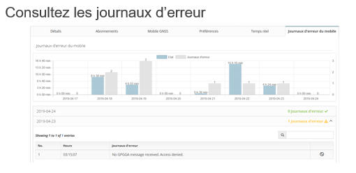
Caution: If no frame is sent to the server, the error message No GPGGA message received. Access denied is added to the error log (see Customer area).
Similarly, if the position sent is zero (all zero) the message Currently no data available. No sites and/or clusters defined. is added to the error log (see Customer area).
The real strength of the Orpheon network
The NRTK (Network Real Time Kinematic) comes from the use of several bases of observations connected together in a network to optimize and model the information of corrections on the covered area.
the positioning accuracy does not depend on the distance to the nearest physical network station.


