The first NRTK FULL GNSS network in France

Orpheon is the first French multi-constellation network in France.

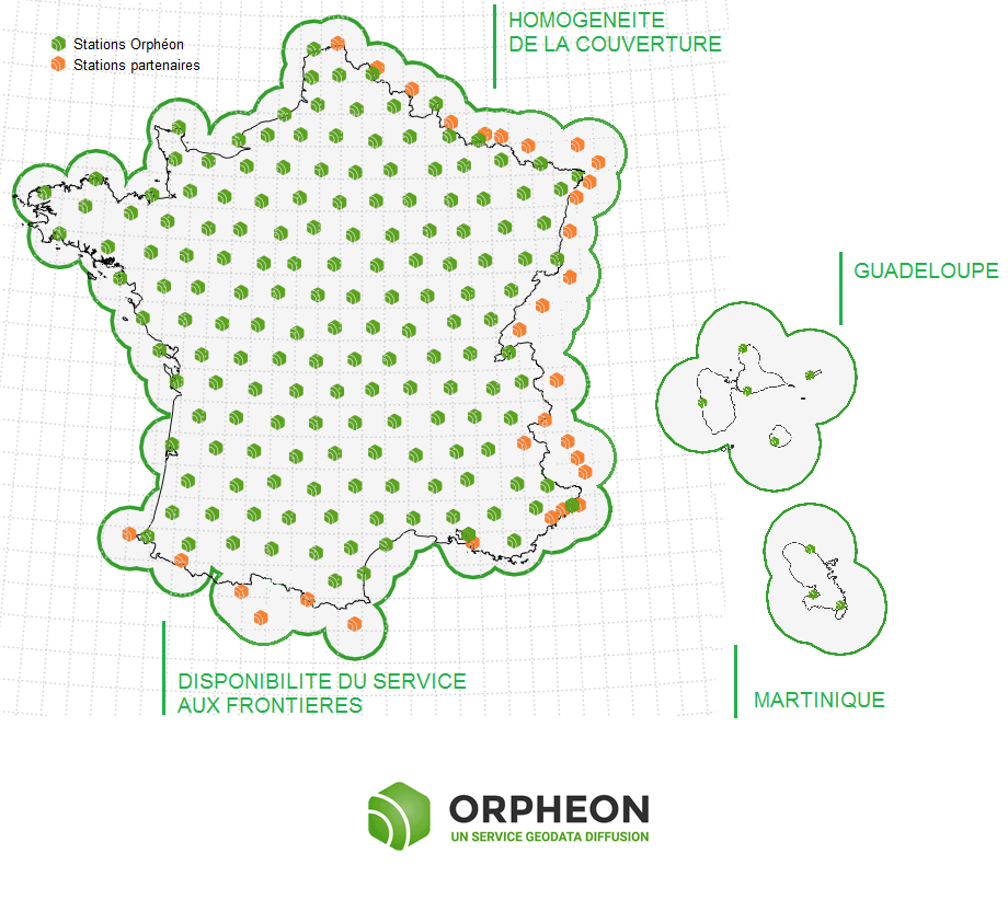
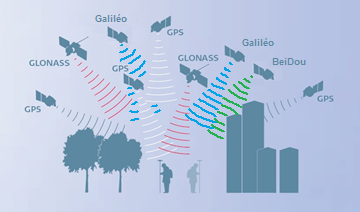
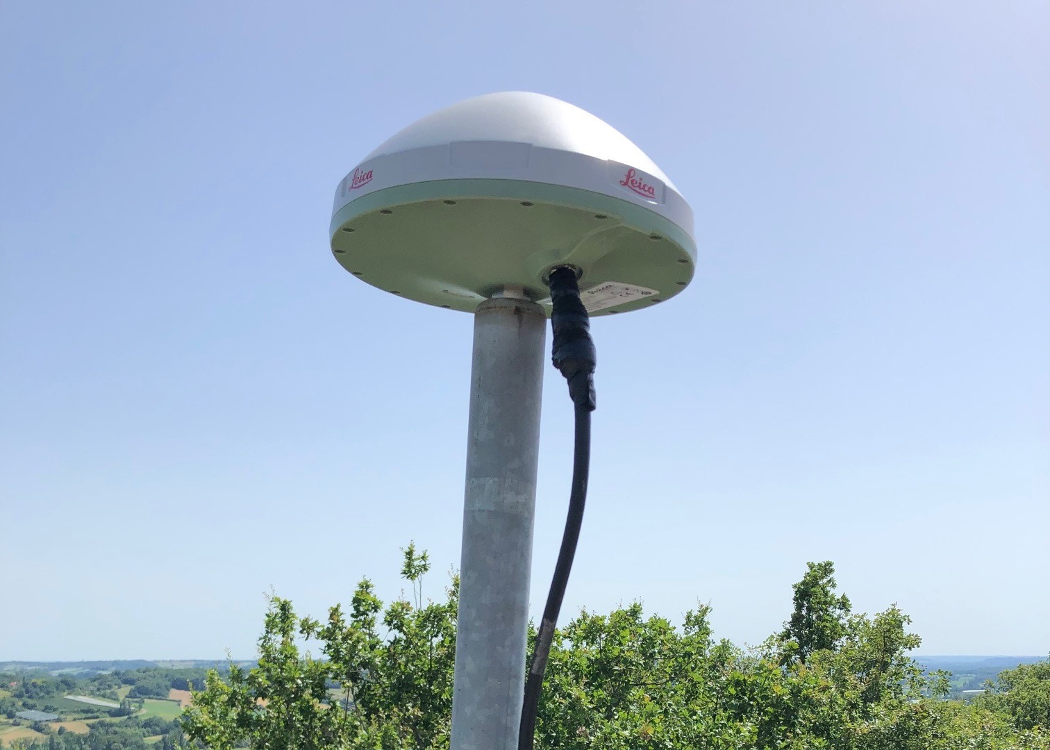
With its 220 stations in France and the West Indies, all Full GNSS: GPS, GLONASS, Galileo and BeiDou with a historical presence in the French West Indies.

null

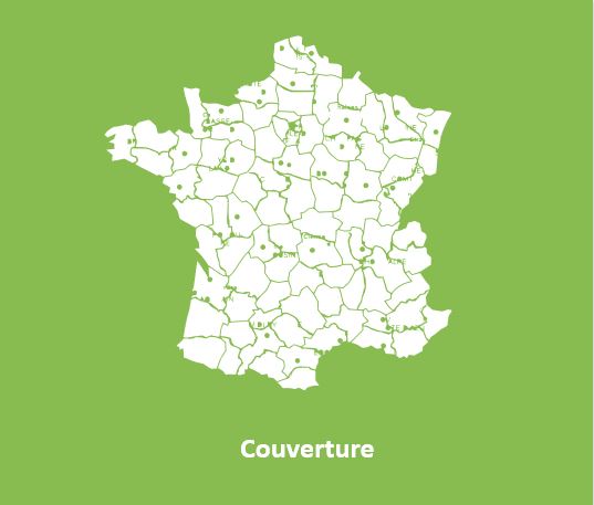
Click on the map to access the interactive network map

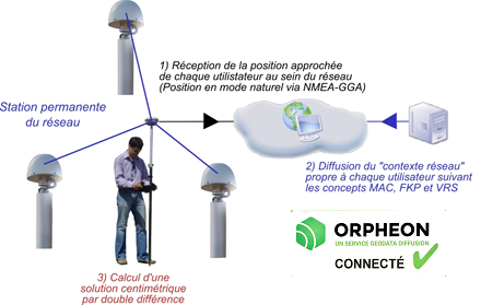
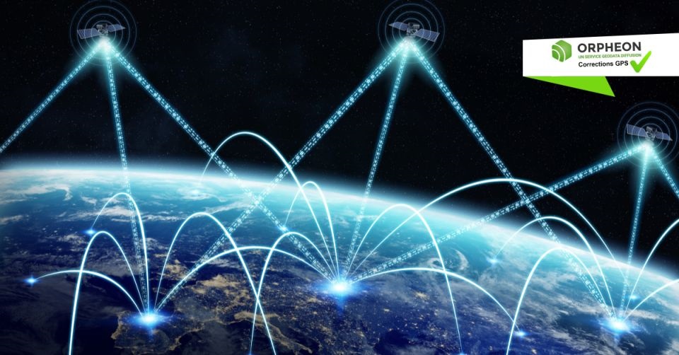
The Orphéon satellite positioning correction system is based on a network of observation reference stations (OSR: Observation Space Representation) spread over the territory, each position of which is known with precision.

All the observations of this network are concentrated on a computing center to deliver to each user corrections allowing him to obtain a much more precise positioning.

OSR services offer positioning accuracy to the nearest centimeter, within the network or within 30 km of the nearest reference station (in single station mode).

Provide RTK or PPK GPS corrections

This network allows us to market correction services to improve GPS positioning (centimetric precision)

Our various services are marketed in the form of subscriptions or hourly packages mainly used by professionals for their daily missions.

  • Topography, GIS, network detection
  • Machine control
  • Agriculture
  • Drones, Robotics
  • Autonomous vehicles
  • Etc

A whole range of services adapted to your needs

Discover each of these high-precision GPS correction services in the form of annual subscriptions or hourly packages.

Each of our offers is flexible to adapt to your real needs.

A very regular presence, without compromise and without equivalent in France.

A regular and homogeneous layout

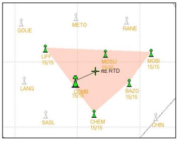
All of our stations form a large balanced and homogeneous GPS network carefully implemented to create a linear and regular geometric mesh and offer uncompromising quality of service with the highest stability.

Territory coverage is uniform wherever you are. With the Orphéon network, you work with identical precision throughout the territory by automatically receiving corrections from a combination of several surrounding stations.

Our strength: positioning accuracy does not depend on the distance to the nearest station or network antenna.

null

High accuracy and availability

Thanks to its precision and the availability of its real-time GPS RTK corrections, the Orpheon network offers increased productivity to all of its users in the fields of topography, construction, 3D digitization, machine control, precision agriculture and bathymetry, but also for new applications concerning autonomous vehicles, drones (UAV) and connected objects (IOT and M2M).

Géodata Diffusion continues to develop the quality of its services through personalized support, responsive technical assistance and continuous improvement of its infrastructures. Our objective is to offer customers a secure and innovative service, guaranteeing them a high and constant utilization rate wherever they are, throughout the territory.

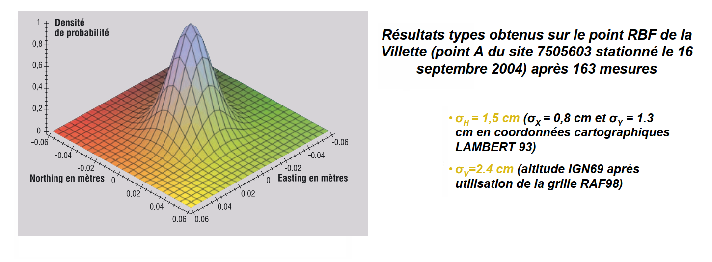
Positioning accuracy with Orphéon is centimetric for a standard deviation of 1σ:

          • between 1 and 2 centimeters in planimetry (Lambert 93).,
          • between 2 and 3 cm in altimetry (IGN69).

The highest availability rate on the market

The strength of the European network is to share infrastructures and the most qualified technical teams to guarantee identical control procedures over the entire coverage area, continuous and regular reinforced monitoring of all stations and the network. This international technical team from a major manufacturer is responsible for supervising all installations 24 hours a day, 365 days a day.

Reinforced coverage

Integration into a large European network

To guarantee a continuous service of constant quality throughout the territory, we share the reference sites within the European network of our Hexagon group.

This European network allows us to integrate additional reference stations and extend the coverage of the Orphéon network for French customers. In this way, even near a border, it is possible to work in a network while being within an RTK cell (and no longer in extrapolated mode).

This coverage is enhanced at borders by sharing reference stations from our international Hxgn SmartNet network with:

  • Belgium
  • Luxembourg
  • Germany
  • Switzerland
  • Italy
  • Spain

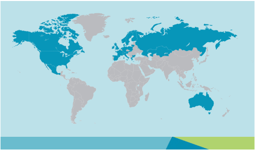
International expertise covering many countries

By integrating the Hexagon Group in 2014, the Orphéon network joined a vast network of reference stations within the first operational European NRTK network covering many countries.

On the strength of its international experience and its expertise in real-time positioning, the Hexagon group, within its various companies, intends to offer the most uniform and extensive real-time positioning service with centimetric precision.

International technical support at your service

This secure infrastructure, set up and managed by the Hexagon group, allows the pooling of technical support resources within the group for all the countries whose management is centralized.

This organization also makes it possible to offer a service available 24/7 and to offer one of the highest availability rates on the market.

GPS Accuracy

The natural position provided by an isolated GPS gives a good idea of ​​where it is within a few meters, but this is not qualitative enough to allow precision work. It requires corrections to obtain centimetric precision that can be used in agricultural work, topography, machine guidance or in many other fields of application (see).

Corrections to gain precision

So that its precision is increased and usable in agricultural work, topography, machine guidance or in many other fields of application (see) . It is essential to use corrections on a continuous basis.

Precision GPS

We distinguish between two types of GNSS receivers:

  • Consumer receivers (Watches, phones, tablets, cars, etc.) which will work only in natural mode with positioning within ± 5 meters of precision without the possibility of improving their precision thanks to broadcast corrections.
  • Precision receivers (RTK), which will be able to integrate external correction data allowing them to obtain positioning with centimeter precision.

RTK

Real-time corrections

The RTK (Real Time Kinematic) is a device allowing real-time transmission of correction data from a single observation base to mobile GPS units through radio communication or via an internet connection.

  • In single-station mode (agriculture), the distance from the nearest reference station is never more than 30 km to guarantee the precision the precision adapted to the needs.

The mobile will then integrate this information into its positioning calculation to gain precision.

N-RTK

The real strength of the Orpheon network

N-RTK (Network Real Time Kinematic) comes from the use of several observation bases connected together in a network to optimize and model correction information on the covered area.

  • In network corrections mode for a centimetric GNSS RTK receiver the positioning accuracy is independent of the distance to the nearest physical network station.
  • With the Orphéon network, you can work with identical precision throughout the territory thanks to a cell of several reference stations created around the user and the homogeneous distribution of the stations over all the areas covered, whatever your position.

null

The data from this network of observation stations is collected in real time on a centralized server. Users’ mobiles then connect to the server via mobile internet to obtain their correction information broadcast in real time.

PPK

Corrections in post-processing

PPK (Post Processing Kinematic) to post-process your positioning data with observation data from an observation station.

Raw positioning data (without corrections) is stored in the GPS in Rinex format along with satellite observations such as satellite ID, frequency (L1/L2/L5, etc.), constellation, pseudorange, carrier phase, Doppler and signal to noise ratios.

RINEX (Receiver Independent Exchange Format) as its name suggests is a standardized format for storing positioning and observation data independent of the brand of the receiver and thus allowing post-processing of this data afterwards to obtain corrected positions. much more precise.

High quality centimetric precision

Full GNSS network and services

null

The infrastructure and the calculation software allow us to deliver positioning corrections for the different GNSS constellations:

Relying on L1, L2 and L5 frequencies emitted by satellites to make positioning more resistant to interference and signal reflections, especially in an urban environment.

Concretely, the initialization time and the delay to fix or convergence are significantly reduced as well as the repositioning times in the event of disconnection. The use of multiple frequencies allows better rejection of repair signals, which allows a maximum of direct signals to be processed, which provides greater precision and greater positioning repeatability.

100% more satellites

The addition of the Galileo and BeiDou satellites to the GPS and GLONASS satellites now makes it possible to double the number of satellites that can be observed simultaneously by a GNSS antenna. The addition of the GALILEO and BeiDou constellations thanks to the Orphéon network is not a simple gadget, but the assurance of better daily productivity in the field.

Improved positioning quality

          • More satellites available to calculate its position
          • Precise positioning even in difficult environments (urban canyons for example or under a canopy)
          • Improved positioning reliability
          • Shorter fixing time
          • Multi-frequency L1/L2 and L5

Everything has been thought out to allow you to benefit from increased productivity.

          • Centimeter accuracy corrections for GPS GNSS
          • Use of L1/L2 and L5 frequencies
          • Real time, very fast convergence time
          • A dense and homogeneous RTK network
          • A regular and geometric layout throughout the territory
          • An infrastructure designed for service performance
          • Very secure facilities
          • National and West Indies coverage
          • A reference for professionals
          • Accuracy, Stability, Availability, Repeatability
          • Increasingly varied applications

The Orpheon network in detail :