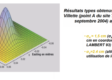
Positioning accuracy with Orphéon is centimetric for a standard deviation of 1σ:
-
-
-
-
- between 1 and 2 centimeters in planimetry (Lambert 93).
- between 2 and 3 cm in altimetry (IGN69).
-
-
-

Technically:
The fact of working in a network makes it possible to obtain, in a few seconds, a homogeneous precision on all the zones covered, whatever the distance separating the mobile from the nearest station. The system is compatible with the vast majority of mobile receivers on the market insofar as the corrections are broadcast in standard formats:
In a standardized format (RTCM3) or in well-defined proprietary formats (CMR/CMR+, MAX, iMAX, LB2)
According to network calculation concepts, which are also well defined and standardized (MAC).
The measure
Field phase recommendations
The popularization of positioning techniques generates certain drifts insofar as all users are not or no longer necessarily aware of the phenomena involved in precision GNSS positioning and do not or no longer have the necessary hindsight on their equipment to work optimally. We thought it appropriate to recall a few recommendations for obtaining quality measurements with a certain level of confidence.
- Control of measurement equipment (Firmware version of GNSS equipment, status of the rod, of the bubble, compliant configuration and configuration)
- Turn on the mobile and stand on a clear point
- Ensure good internet connection and service stability
- Connect to real-time correction services
- Start a first initialization session (8 minutes without cycle jumps for 6 satellites being a fairly widespread minimum recommended value) for the subsequent fixing of integer ambiguities
- Centre, bubble, check antenna height and stability
- Perform measurement work while ensuring GNSS measurement conditions: sufficient number of satellites, GDOP < 3 – 4, SNR > 50 (on L1) or 40 (on L2)
- In the event of a cutoff warning by the receiver or in the event of lifting in a place prone to signal cutoffs (near trees, buildings, etc.), redo an initialization session
- Reoccupy the first point at the end of the lift
- Reoccupy the important points at least once after at least 20 minutes (see control sheet)
- Occupation of all known points in coordinates (RBF, NGF) (see check sheet)
it is also recommended to save the raw data in static as in itinerant in order to be able to recalculate in post-processing the whole of the chain
kinematics measured from data observed on the stations of your real-time operator and/or those of the RGP, NPPK (Network Post Processing Kinematic) method.
You will also find an article published in XYZ on the subject Real-time static positioning by “filtering and averaging NRTK positions”
This method of measurement makes it possible to ensure the quality of the points recorded.
Dilution of GDOP, HDOP accuracy …
The HDOP, a question of geometry
The positioning accuracy of a satellite navigation system (GPS) is affected by mathematical errors related to the geometry of the observable satellites either because of their position and their distribution above the user. which can be defined as:

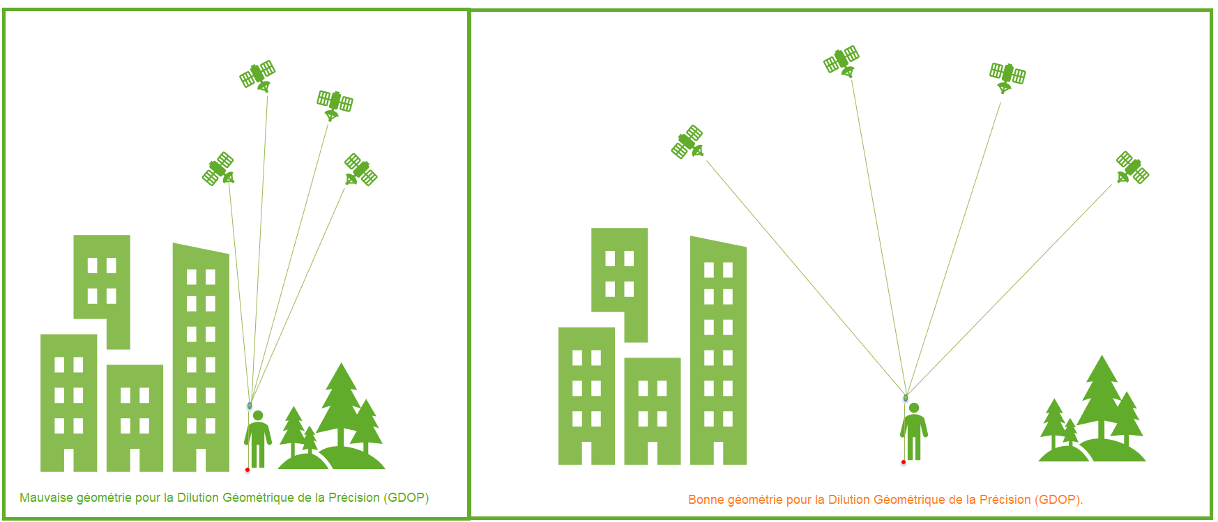
The idea of Geometric DOP (GDOP) is to indicate how measurement errors will affect the final state estimate.
DOP can be expressed in a number of distinct measurements :
- HDOP – horizontal dilution of precision
- VDOP – vertical dilution of accuracy
- PDOP – position dilution (3D) of accuracy
- TDOP – temporal dilution of precision
- GDOP – geometric dilution of precision
Benchmarks
These values derive mathematically from the positions of the usable satellites. The signal receivers allow the display of these positions (skyplot) as well as the DOP values.
| Valeur DDP | Classement | La description |
|---|---|---|
| <1 | Ideal | Highest possible level of confidence to be used for applications requiring the highest possible accuracy at all times. |
| 1-2 | Excellent | At this level of confidence, position measurements are considered accurate enough to meet all but the most sensitive applications. |
| 2-5 | Good | Represents a level that marks the appropriate minimum for making accurate decisions. Position measurements could be used to make reliable navigational suggestions to the user. |
| 5-10 | Moderate | Position measurements could be used for calculations, but the quality of the correction could still be improved. A clearer view of the sky is recommended. |
| 10-20 | Fair | Represents a low confidence level. Position measurements should be ignored or used only to indicate a very rough estimate of the current location. |
| >20 | Poor | At this level, measurements are inaccurate out to 300 meters with an accurate 6 meter device (50 DOP × 6 meters) and should be discarded.. |
Underground networks
Topographic work of specific precisions
In various theses on “TOPOGRAPHIC WORKS” it is highlighted that the use of a “real time GPS” is sufficient for the realization of topographic works of class of precision 10 cm within the meaning of the decree of September 16, 2003 (Class A), only within the limits of use of the equipment (pay attention to the close environment) and the limit of implementation of survey methods (see our field phase recommendations above).
The new regulations reinforce the obligation to ensure the safety of the works by the project owner thanks to the precise location of the networks. Thus, all recipient operators of a work request (DT) will be required to transmit network location data so that the work can be carried out in complete safety.
The networks will be qualified according to three accuracy classes:
- A class (40 cm, which amounts to taking readings with a precision of 10 cm),
- B class (Between 40 cm and 1.0 m)
- C classe (greater than 1.0m).
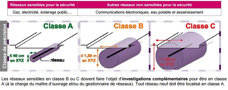
When the work is located near sensitive underground networks (gas, electricity), class A location data will be required. Failing this, project owners will have to undertake additional investigations (IC) in order to have class A information. Operators will be required to integrate the results of these additional investigations into their databases and to carry out topographical surveys. new class A networks using a geo-referenced and pooled base plan. The regulations set new obligations for construction companies.
These include:
- the interruption of work on a site as soon as a dangerous situation is encountered and
- strengthening the skills of machine operators and site managers in the field of work safety near networks, obligations which will be subject to periodic updates and verification.
A need for precision and geo-referencing
Because of this need for precision and geo-referencing, the detection equipment will have to be supplemented by a precision GPS. The natural position given by a GPS alone gives a good idea of where it is within a few meters, but is not precise enough to achieve the necessary and requested precision. These GPS require a correction so that their precision is increased and usable within the legal framework imposed.
The GPS implemented must make it possible to provide geolocation:
- X : longitude
- Y : latitude
- Z : altitude (and depth)
These data will then enrich or update the GIS (Geographic Information Systems) data.
Declaration of work near underground networks (DT DICT)
Reminders : The work planned near pipelines and buried networks must be declared to their operators, before their execution, by means of the declaration of project of works (DT) by the client, and the declaration of intention to start (DICT) by the contractor. Any declaration must be preceded by a consultation of the one-stop shop, accessible online, which lists all the networks present in the territory.


