Share the post "Management of ski resorts and mountainous areas"
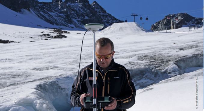
![]() Orphéon is a real-time RTK Full GNSS precision augmentation GPS correction system allowing users to position themselves with centimeter precision in the national reference anywhere in France and the West Indies with a single GNSS receiver.
Orphéon is a real-time RTK Full GNSS precision augmentation GPS correction system allowing users to position themselves with centimeter precision in the national reference anywhere in France and the West Indies with a single GNSS receiver.
Ski resorts management
Sustainable development is now at the heart of farm management and requires more and more precision.- For perfect snow cover management
- For monitoring areas in the massif
- For accurate mapping of all installations
- For prevention and safety programs
- For the management of networks traversing the domain
- For the preparation and implementation of development projects
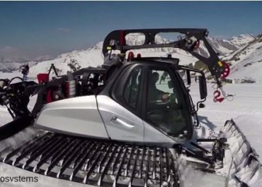
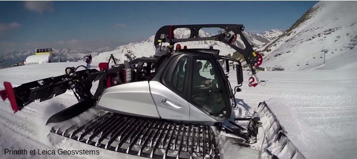
Machine guidance
The preparation of the ski slopes requires attention and greater efficiency to which the Orphéon precision geopositioning associated with a guidance of grooming machines responds directly by providing comfort, safety and increased quality.- Safety: Work in very poor visibility conditions (night, fog, snowfall)
- Better efficiency: reduction of fuel consumption, costs, carbon emissions.
- Greater quality: precise placement of the machines and regularity of the distribution of the snow cover with precise measurement.

GPRS mobile phone transmission
(3G modem for example) has now proven itself with a national territory coverage rate of almost 99%. It is gradually supplanting radio transmission thanks, in particular, to the additional services it authorizes:
- in addition to Orpheon RTK correction services
- remote assistance*
- telematics*
- the download*
Now available on board (see Extended Flow SIM cards). The possibilities are endless to meet the growing needs of farms. This technology is compatible with all brands of equipment.
The Most Geodata
With an extended flow SIM card, your field notebook or your tablet connected to the internet, for remote assistance, downloading, etc. (Choice of SIM cards)
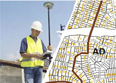
Cartography surveys, GIS
Today, every drinking water, waste water and water pipe for snow cannons, as well as all cables and conduits are accurately surveyed, mapped and can be viewed at any time.
- More precise positioning of networks
- Reduced risk of damage
- Consultable and shared at all times
But also these cartographic surveys are used to prepare and carry out specific mountain developments.
Monitoring of structures and unstable areas
The stability of a slope or cliff can be affected by the following external factors:
- climatic phenomena: rain, snowmelt, cyclone, monsoon, freeze-thaw cycle, thermal gradient;
- hydrological phenomena: modification of superficial and deep flows, coastal erosion, erosion of the foot of the slope by the bed of a watercourse, rapid reduction in the level of a river at the foot of the slope, flooding, impoundment of a blocade ;
- phenomena that are sources of vibration: earthquake, vibration linked to mining activity or the presence of infrastructure;
- anthropogenic actions: earthworks at the foot of the slope, overloading at the crest, insufficient control of water discharges and surface runoff. The presence of water, through the development of pore pressures in the unstable mass of soils or rocks, is often considered to be the preponderant triggering factor.
- Safety of installations and populations
- Warning and risk prevention systems
- Maintenance and renovation program
- Development plans, reforestation, grassland
- Watershed management
Ouvrage d’art
Monitoring the phenomenon of aging of engineering structures consists of identifying and then monitoring the signs that reflect this aging and monitoring the effectiveness of the measures implemented to control it. Depending on the nature, structure and classification of the works concerned, various monitoring programs are put in place; either by regular inspection visits, or by the installation of permanent monitoring means.
Unstable areas
Similarly, the monitoring of unstable areas consists of identifying cracks and shifts in the ground. tracking of ground movements using GPS measurements is carried out in the most active areas. These measurements made it possible to know that the earth moves in places by 80 cm per year on average, imperceptibly.
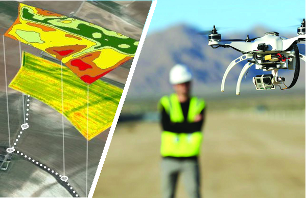
Drone interventions
The intervention of the Drones makes it possible to carry out on areas covering several hectares very quickly by avoiding operators or surveyors to move on foot with their heavy measuring equipment and thus carry out hundreds, even thousands of measurements and shooting. In addition, the drone makes it possible to carry out surveys in dangerous areas and thus prevent people from exposing themselves to these dangers, this may be the case in quarries in the presence of construction machinery or even in unstable areas. as in landslides, which makes it possible to assign them increasingly varied professional missions, particularly in GIS.