
Orphéon is the first French multi-constellation network in France.
Metropolitan France, Antilles and Guadeloupe
The positioning accuracy is independent of the distance to the station
In NRTK network corrections mode the centimeter accuracy is independent of the distance to the nearest physical network station.
With the Orphéon network, you work with identical precision throughout the territory thanks to a cell of several reference stations created around the user and the homogeneous distribution of the stations over all the areas covered, whatever your position. You receive corrections from a combination of multiple stations for greater stability and accuracy.
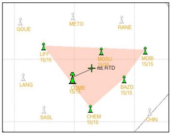
A cell of several stations surrounding the user and regular and homogeneous layout
In single-station mode (agriculture), the distance from the nearest reference station is never more than 30 km.
A single setting
There is only one hardware configuration to connect to the network anywhere in France, it is our server which is responsible for automatically establishing the cell of observation stations that suits you.
The geometric regularity of our layouts
The Orpheon network has 220 stations in mainland France, all Full GNSS i.e.: GPS, GLONASS, Galileo and BeiDou as well as a historical presence in the French West Indies.
The dense network of permanent stations is arranged regularly every 60 km. Each link in the Orphéon infrastructure has been designed to offer a high-precision RTK correction service available in all circumstances. Border areas are complemented by our partnership agreements within Europe.
A very regular presence, without compromise and without equivalent in France.
The careful choice of layout for each of our 215 reference stations creates a linear and regular geometric mesh. Territory coverage is uniform wherever you are.
The Orphéon network thus stands out significantly from its competitors who are multiplying the number of reference stations because of their disorderly location on the territory and whose coverage is losing homogeneity, sometimes leaving very large distances in the meshes of their network.
Interactive maps of the Orpheon network
Integration into a large global network
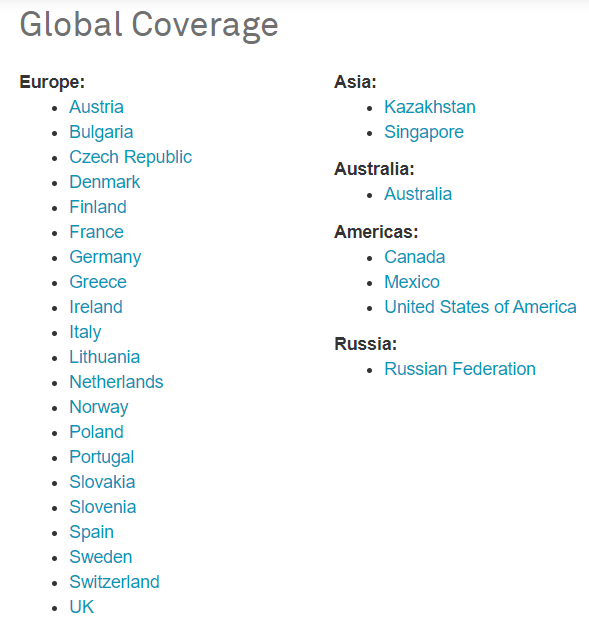
HxGN SmartNet allows you to travel without interruption
in more than 20 European countries.
This secure infrastructure, set up and managed by the Hexagon group, allows the pooling of resources whose management is centralized. It also allows you to organize a service available 24/7 and offer one of the highest availability rates on the market.
Increasing real-time positioning accuracy has become a critical issue and requirement for high-growth areas such as autonomous navigation and precision agriculture.
Drawing on its international experience and its expertise in real-time positioning, the Hexagon group, within its various companies, intends to offer the most homogeneous and most extensive real-time positioning service with centimeter precision.
To guarantee continuous service and consistent quality throughout the entire territory, we share reference sites within the European network of our Hexagon AB group..
The service is marketed under the HxGN SmartNet brand
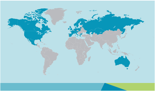
With more than 5,300 reference stations worldwide, HxGN SmartNet is the world’s largest provider of satellite-based correction services (GNSS).
![]()
The highest availability rate on the market
The strength of the European network is to share infrastructures and the most qualified technical teams to guarantee identical control procedures across the entire coverage area, continuous and regular reinforced monitoring of all stations and the network. This international technical team from a major manufacturer is responsible for supervising all installations 24 hours a day, 365 days.

By joining the Hexagon group in 2014, the Orphéon network joins a vast network of reference stations within the first operational European NRTK network operating in 25 countries including 18 in Europe. Drawing on its international experience and its expertise in real-time positioning, the Hexagon group, within its various companies, intends to offer the most consistent and extensive real-time positioning service with centimeter precision.