 Positioning accuracy with Orpheon is centimeter for a standard deviation of 1σ:
- Included between 1 and 2 centimeters in planimetry,
- Included between 2 and 3 cm in altimetry.

Download the technical sheet
Referencing and external control of the network
The referencing of the sites and the monitoring of their stability is ensured by the RENAG, National Observatory, implementing and using continuous GPS measurements for scientific purposes such as: measurement of weak crustal deformations, study of the vapor content of atmospheric water, study of oceanic and hydrostatic overload or even study of gravitational movements. Géodata Diffusion is a private partner of RENAG (see the RENAG website)Stationing procedure
After the final installation of a reference station on a new site or after maintenance, we obtain an initial approximate position of this site by observations over a minimum period of 72 hours. This duration makes it possible to obtain the first coordinates of the site. Then these observations are conducted over a month in order to acquire the time series that will be used to calculate the position using the Bernese GNSS software: high-precision scientific multi-GNSS data processing software developed at the Astronomical Institute of the University of Bern (AIUB). All the sites are referenced in the RGF93 via a “state of the art” procedure from the stations of the RGP (Permanent GNSS Network). We then obtain the position and the precise three-dimensional coordinates of the site which we can then integrate into the network to deliver the correction services.Self-checking and monitoring
On a daily basis, we monitor 24 hours a day, all year round, the positioning of each of our reference stations using monitoring tools integrated into our correction calculation platforms (Spider and/or TPP). The monitoring of each of the reference stations is then carried out on a regular basis in order to control the stability of the sites. Internal quality control procedures are carried out regularly. In the field, we regularly check and compare the corrections obtained from the network by positioning ourselves with a mobile GNSS receiver, as our customers would do, on known points such as IGN terminals whose three-dimensional coordinates are known with precision.Automatic alerts
The entire network is monitored 24 hours a day and alerts are sent in real time to our technical support as soon as a movement or shift of a reference station is observed by the system. Our team is then able to intervene to ensure that a constant quality of service is maintained over time.
- three-dimensional geocentric
- linked to the global ITRS reference system
- associated with the IAG GRS 1980 spheroid
- having as its prime meridian the International Meridian (or Greenwich Meridian)
- having as associated projections the Lambert-93 projection and the CC 9
- Zones projections
- horizontal accuracy between 1 and 2 cm (compared to global systems)
- vertical accuracy between 2 and 5 cm (compared to global systems)
- suitable for modern positioning techniques
Since January 2021 :
In 2019 and 2020, IGN carried out the IGS14 reprocessing and cumulation of the Permanent GNSS Networkexternal link. This has led to the release of a new RGF93, named RGF93 V2b, which is aligned with ETRF2000 epoch 2019.0. This replaces in January 2021 the RGF93V2 benchmark, which was directly compatible with the ETRF2000 era 2009.0.In 2010 :
A first readjustment to the European system took place in 2010, following the re-observation of the base network (RBF) systematically using the Permanent GNSS Network. The published coordinates are then expressed in a version 2 of the RGF93 frame which corresponds to the ETRF2000 at the epoch 2009.0.Impact:
The impact of this update is mainly reflected on the ellipsoidal heights and, consequently, on the evolution of the elevation conversion surface.RAF20:
Since the summer of 2021, you can therefore download this new ‘grid’ from the IGN website (https://geodesie.ign.fr) which takes into account both the evolution of the RGF93 benchmark (ETRF2000 ep.2019.0) and the last two ERNIT field campaigns 2019 and 2020 in mainland France. IGN is also trying to improve the model at each occurrence by introducing some minor corrections from reports or redeterminations caused by local tectonic activity. For mainland France, the RAF20 altimetric conversion surface was updated at the end of 2021 to take into account the maintenance operations of the RGF93 reference mark Pour la Corse, la surface de conversion altimétrique RAC09 reste en vigueur.- three-dimensional geocentric
- linked to the global ITRS reference system
- associated with the IAG GRS 1980 spheroid
- having as its prime meridian the International Meridian (or Greenwich Meridian)
- having as associated projections the Lambert-93 projection and the CC 9
- Zones projections
- horizontal accuracy between 1 and 2 cm (compared to global systems)
- vertical accuracy between 2 and 5 cm (compared to global systems)
- suitable for modern positioning techniques
- RGF93.v1: ETRF2000 solution at date:t0=1993.0
- RGF93.v2: ETRF2000 solution at date:t0=2009.0
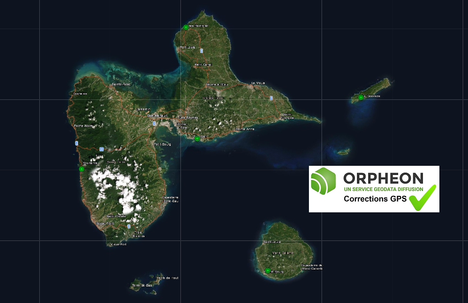 The RGAF09 (Réseau Géodésique des Antilles Françaises 2009) thus replaces the WGS84-RAAF91, which remains however usable for an overlay period of three years.
RGAF09 is a significant improvement over WGS84.
Indeed, it had inconsistencies of several centimeters between the islands as well as an offset of about 70 cm with the International Terrestrial Reference System (ITRS).
The RGAF09 (Réseau Géodésique des Antilles Françaises 2009) thus replaces the WGS84-RAAF91, which remains however usable for an overlay period of three years.
RGAF09 is a significant improvement over WGS84.
Indeed, it had inconsistencies of several centimeters between the islands as well as an offset of about 70 cm with the International Terrestrial Reference System (ITRS).
RGAF09 as standard on the Orphéon network
As of Monday, December 16, 2019 at 06:30 UTC the Orpheon network uses RGAF09
Directly in RGAF09
The change is direct without user intervention. No modification is therefore necessary for customers using the Orphéon network, as soon as they connect to the network, the coordinates will be expressed directly in the new official reference WGS84-RGAF09.The RAAF91 – Always Available
However, for more than 10 years the Orpheon network has been working in the national coordinate reference system WGS84-RAAF91 which will therefore remain valid for another 3 years. Professional network users have become accustomed to using Orpheon and have configured their equipment and their work accordingly. We keep this possibility not to suddenly upset the work of many professionals.Keep the old reference system RRAF91
Some network users may still need to work with the old RRAF91 reference system for a while longer, to complete a job or resume an old survey without having to do any prior conversion.We thought of them:
We provide you with new mounting points allowing you to work in the old reference system. Reverting to RRAF91 will require setting up your hardware by selecting one of the new mount points that matches your setup.-
-
- RRAF91_i-MAX_3.0_GG
- RRAF91_i-MAX_MSM_FULL
- RRAF91_VRS_3.0_GG
- RRAF91_VRS_MSM_FULL
- RRAF91_MAX_3.0_GG
- RRAF91_FKP_3.0_GG
- RRAF91_Plus-Pres_3.0_GG
- RRAF91_Plus-Pres_MSM_FULL
-
Confusions and changes
The coexistence of two coordinate reference systems in parallel leads to some confusion that we too have seen. Some of our customers have recently reported to us an Orphéon RTK real-time and post-processing positioning problem in Guadeloupe related to the use of different coordinate systems in the same project. They were thus able to observe differences of the order of 60 cm. But as soon as the points used in a project are expressed in the same coordinate system, things get back to normal and customers find all the precision of the Orpheon network. Projects must be treated in their entirety in a single coordinate system, without being mixed.Coordinate transformation:
It is possible to use our online transformation tool or IGN provides the transformation parameters from local systems and WGS84-RRAF to the RGAF09 system as well as a CIRCE tool.RGAF09 as standard on the Orphéon network
As of Monday, December 16, 2019 at 06:30 UTC the Orpheon network uses RGAF91
Directly in RGAF91
The change is direct without user intervention. No modification is therefore necessary for customers using the Orphéon network, as soon as they connect to the network, the coordinates will be expressed directly in the new official reference WGS84-RGAF09.The RAAF91 – Always Available
However, for more than 10 years the Orpheon network has been working in the national coordinate reference system WGS84-RAAF91 which will therefore remain valid for another 3 years. Professional network users have become accustomed to using Orpheon and have configured their equipment and their work accordingly. We keep this possibility not to suddenly upset the work of many professionals.Keep the old reference system RRAF91
Some network users may still need to work with the old RRAF91 reference system for a while longer, to complete a job or resume an old survey without having to do any prior conversion.We thought of them:
We provide you with new mounting points allowing you to work in the old reference system. Reverting to RRAF91 will require setting up your hardware by selecting one of the new mount points that matches your setup.-
-
- RRAF91_i-MAX_3.0_GG
- RRAF91_i-MAX_MSM_FULL
- RRAF91_VRS_3.0_GG
- RRAF91_VRS_MSM_FULL
- RRAF91_MAX_3.0_GG
- RRAF91_FKP_3.0_GG
- RRAF91_Plus-Pres_3.0_GG
- RRAF91_Plus-Pres_MSM_FULL
-
Switch from RRAF91 to RGAF09?
Coordinate transformation:
It is possible to use our online transformation tool or IGN provides the transformation parameters from local systems and WGS84-RRAF to the RGAF09 system as well as a CIRCE tool. Helmert parameters necessary for the transformation of coordinates expressed in old systems to RGAF09. IGN provides the parameters needed to transform RRAF91 coordinates into RGAF09 and vice versa. It is therefore possible to indirectly link GNSS work carried out in other systems to the RRAF91 reference. The table below lists the values of these parameters. Note in particular the values of the translations between the RRAF91 and the RGAF09 which differ up to 10 m depending on the area concerned. This testifies to the heterogeneity of the inter-island RRAF91.| Zone | Martinique | Guadeloupe | Guadeloupe | Martinique | Guadeloupe | Guadeloupe |
| Système de départ | Fort Desaix | Saint-Anne | Fort Marigot | RRAF91 | RRAF91 | RRAF91 |
| Système d’arrivée | RGAF09 | RGAF09 | RGAF09 | RGAF09 | RGAF09 | RGAF09 |
| TX (m) | 127.744 | -471.060 | 151.613 | 0.7696 | 1.2239 | 14.6642 |
| TY (m) | 547.069 | -3.212 | 253.832 | -0.8692 | 2.4156 | 5.2493 |
| TZ (m) | 118.359 | -305.843 | -429.084 | -12.0631 | -1.7598 | 0.1981 |
| RX (arcsec) | -3.1116 | 0.4752 | -0.0506 | -0.32511 | 0.03800 | -0.06838 |
| RY (arcsec) | 4.9509 | -0.9978 | 0.0958 | -0.21041 | -0.16101 | 0.09141 |
| RZ (arcsec) | -0.8837 | 0.2069 | -0.5974 | -0.02390 | -0.04925 | -0.58131 |
| D (ppm) | 14.1012 | 2.1353 | -0.3971 | 0.2829 | 0.2387 | -0.4067 |
As a reminder, in order to be able to position itself within a few centimeters, a GPS/GNSS rover must be able to:
- perform noise-free phase measurements on at least 5 satellites well distributed in space,
- and receive differential corrections on these same 5 satellites.
- Control of measurement equipment (Firmware version of GNSS equipment, status of the rod, of the bubble, compliant configuration and configuration)
- Turn on the mobile and stand on a clear point
- Ensure good internet connection and service stability
- Connect to real-time correction services
- Start a first initialization session of 8 minutes without cycle jumps for 6 satellites being a recommended minimum value for the subsequent fixing of integer ambiguities
- Centre, bubble, check antenna height and stability
- Perform measurement work while ensuring GNSS measurement conditions: sufficient number of satellites, GDOP < 3 – 4, Signal/Noise ratio SNR > 50 (on L1) or 40 (on L2)
- Respect sufficiently long point acquisition times according to the situation, the environment and the place
- In the event of a cut warning by the receiver or in the event of lifting in a place prone to cuts signal (near trees, buildings, etc.), redo an initialization session
- Reoccupy the first point at the end of the lift
- Reoccupy the important points at least once after at least 20 minutes (see control sheet)
- For the most important or difficult to access points, recording of raw data in Rinex for possible online control post-processing
- Occupation of all known points in coordinates (RBF, NGF) (see check sheet)
 At Geodata Diffusion, we also use these terminals to regularly check that the corrections we deliver through the Orphéon network comply with the specifications we announce.
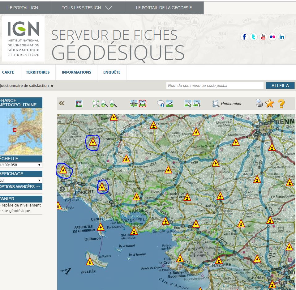
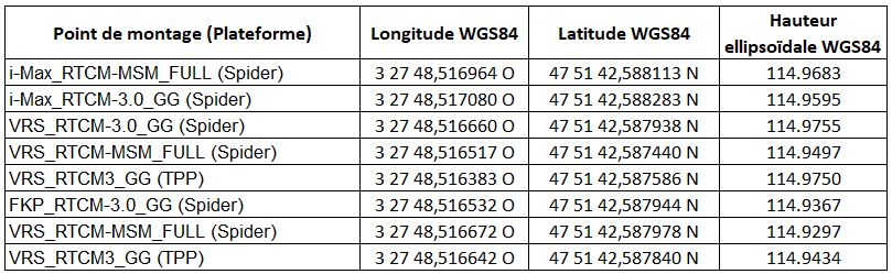
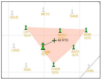
On October 26, 2018 for example,
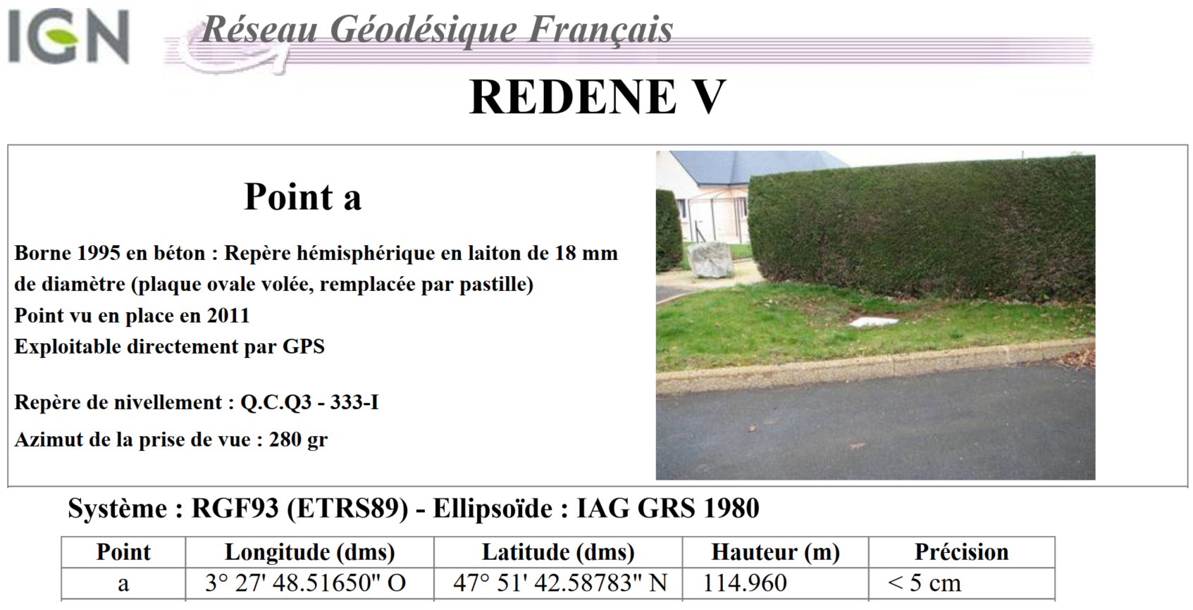
We went to the Lorient region (56) to check the corrections of the Orphéon network and check the potential discrepancies between the data from three IGN terminals and the positions obtained in the field (located on the map above). For each of the sites, we have edited the IGN Geodesic sheet and we are taking readings as follows:- Start-up of the measurement equipment and first initialization session of at least 8 minutes.
- Recording of 6 surveys from the 6 mounting points delivered in GG and Full GNSS. Please note that the correct configuration of the hardware is essential and must correspond to each of the protocols linked to the selected mount point. The risk is to obtain distorted results with erroneous positions (especially in Z).
- Each point is recorded after at least 60 seconds of acquisition. We then make a 30-minute acquisition in natural mode so that we can then perform a control post-processing (Rinex file recording)
- We check our measurements one last time by recording at least one additional point with a Full GNSS mount point.
Results on the REDENE reference terminal (56)
The HDOP, a question of geometry
The positioning accuracy of a satellite navigation system (GPS) is affected by mathematical errors related to the geometry of the observable satellites either because of their position and their distribution above the user.
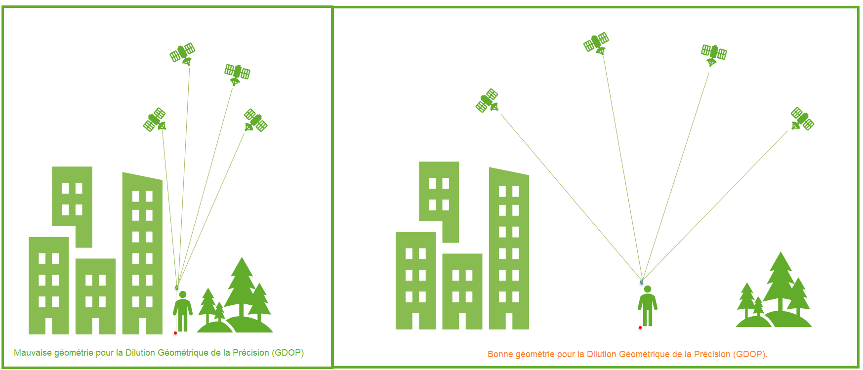 The idea of geometric DOP (GDOP) is to indicate how measurement errors will affect the final state estimate.
DOP can be expressed in a number of distinct measures:
The idea of geometric DOP (GDOP) is to indicate how measurement errors will affect the final state estimate.
DOP can be expressed in a number of distinct measures:
- HDOP – horizontal dilution of precision
- VDOP – vertical dilution of accuracy
- PDOP – position (3D) dilution of accuracy
- TDOP – temporal dilution of accuracy
- GDOP – geometric dilution of precision
Benchmarks
These values derive mathematically from the positions of the usable satellites. The signal receivers allow the display of these positions (skyplot) as well as the DOP values
| Valeur DDP | Classement | La description |
|---|---|---|
| <1 | Idéal | Niveau de confiance le plus élevé possible à utiliser pour les applications exigeant la plus grande précision possible à tout moment. |
| 1-2 | Excellent | À ce niveau de confiance, les mesures de position sont considérées comme suffisamment précises pour répondre à toutes les applications, sauf les plus sensibles. |
| 2-5 | Bien | Représente un niveau qui marque le minimum approprié pour prendre des décisions précises. Les mesures de position pourraient être utilisées pour faire des suggestions de navigation fiables à l’utilisateur. |
| 5-10 | Modérer | Les mesures de position pourraient être utilisées pour les calculs, mais la qualité de la correction pourrait encore être améliorée. Une vue plus dégagée du ciel est recommandée. |
| 10-20 | Équitable | Représente un niveau de confiance faible. Les mesures de position doivent être ignorées ou utilisées uniquement pour indiquer une estimation très approximative de l’emplacement actuel. |
| >20 | Pauvre | À ce niveau, les mesures sont imprécises jusqu’à 300 mètres avec un appareil précis de 6 mètres (50 DOP × 6 mètres) et doivent être rejetées. |
Sky map
Example of observation of the sky of the GPS and Glonass constellations with a cut-off angle of 45° compared to the sky map in Full GNSS with a cut-off angle of 10°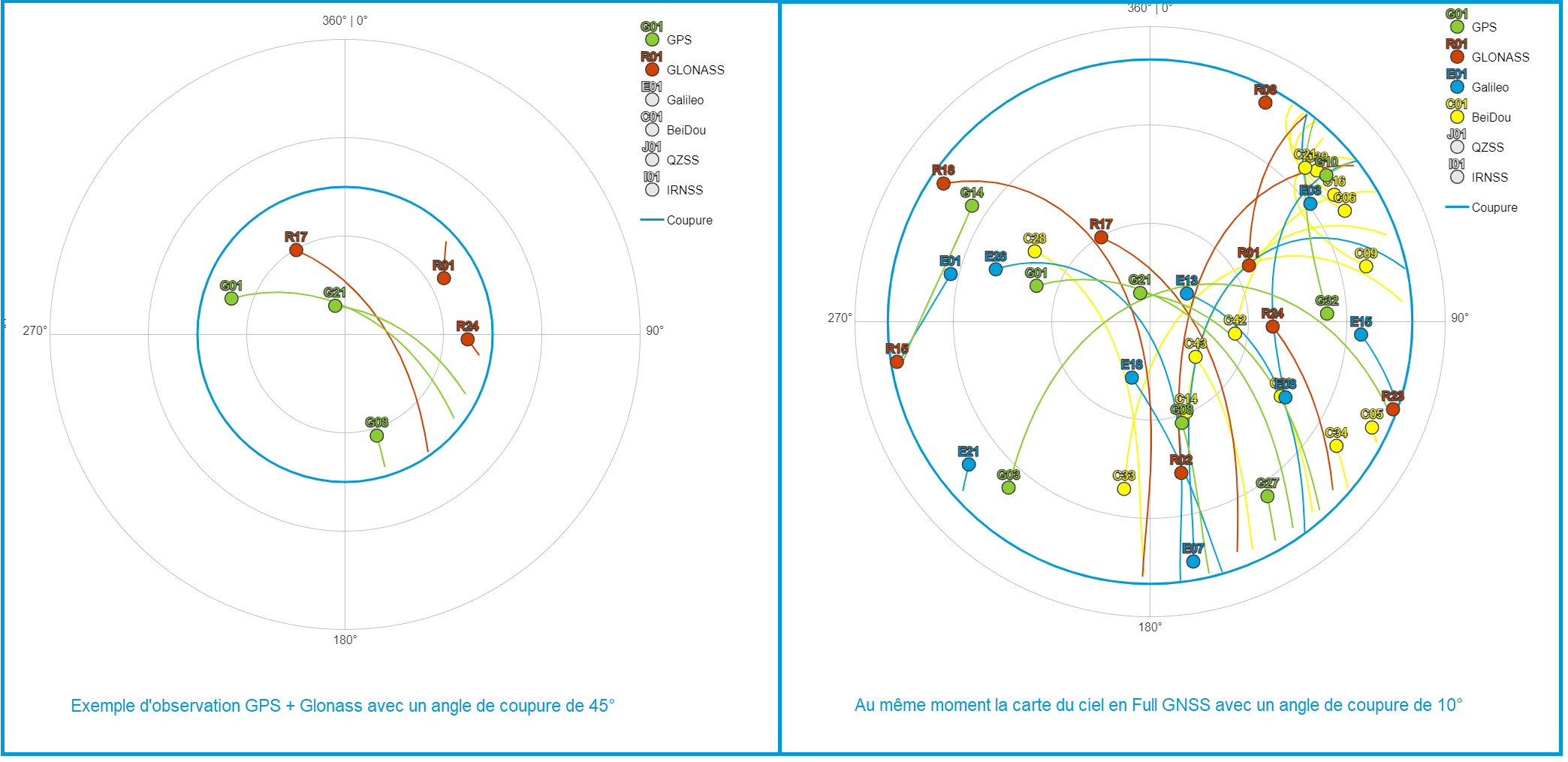
In case of wrong choice of mounting point:
- You will not be able to connect to our servers and therefore you will not be able to obtain a correction. You will therefore not have the expected precision. Your position will remain in natural or floating mode (without correction) the material failing to fix the ambiguities. On the Smartphone application, the symbol locating your equipment will be in red.
- You will manage to connect to our servers but the corrections you get will be misinterpreted by your equipment. You will therefore not have the expected precision. On the Smartphone application, your position will apparently be fixed (with correction), the symbol locating your equipment will be in green.
Self-check recommendations
In our recommendations for field phase measurement, we recommend the occupation of all known points in coordinates (RBF, NGF). To know these points near your site, the IGN provides you with the location of its terminals as well as a wealth of very useful information for the whole of France, Accès au site de l’IGN (click to open link)
- Control of measurement equipment (Firmware version of GNSS equipment, status of the rod, of the bubble, compliant configuration and configuration)
- Turn on the mobile and stand on a clear point
- Ensure good internet connection and service stability
- Connect to real-time correction services
- Start a first initialization session (8 minutes without cycle jumps for 6 satellites being one fairly widespread minimum recommended value) for subsequent fixing of integer ambiguities
- Centre, bubble, check antenna height and stability
- Perform measurement work while ensuring GNSS measurement conditions: sufficient number of satellites, GDOP < 3 – 4, SNR > 50 (on L1) or 40 (on L2)
- In the event of a cut warning by the receiver or in the event of lifting in a place prone to cuts signal (near trees, buildings, etc.), redo an initialization session
- Reoccupy the first point at the end of the lift
- Reoccupy the important points at least once after at least 20 minutes (see control sheet)
- Occupation of all known points in coordinates (RBF, NGF) (see check sheet)
Learn more: Contact our Technical Service who will bring you concrete help and guide you step by step.
Significant solar activity every 11 years
Solar activity follows an eleven-year cycle, with 2015 being a maximum of this cycle. This year 2020 is therefore synonymous with the end of a cycle of reduced ionospheric disturbances for our applications. We must expect in the future to have to deal with increasing solar activity, hence the importance of having a dense network of permanent GNSS stations to properly model this error. As you can see in the graph below, the cycle of solar activity is reaching its minimum and the forecast for this activity is now on the rise:

Disturbances related to geomagnetic storms
As you can see on the SpaceWeatherLive.com website, this phenomenon is global with an ionospheric index K (quantification of geomagnetic disturbances). This is an average of the K indices relating to 13 stations located between 44 and 60◦ latitude; it is therefore an overall index. The K index is a local index which characterizes the variation of the magnetic field at the station considered compared to a calm reference day; these measurements are made using magnetometers. The Kp index scale includes
10 rungs:
The K index is a local index which characterizes the variation of the magnetic field at the station considered compared to a calm reference day; these measurements are made using magnetometers. The Kp index scale includes
10 rungs:
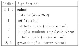
The levels of the Kp Index
The impact on your connection
As you will have understood on this subject, if you have problems in the middle of the day (abnormally long time to fix the entire ambiguities or impossibility of fixing them in clear environments, repeated passages while floating even though you receive many corrections, etc. .), check the number and distribution of GPS satellites and check ionospheric activity via the site:http://gpsweather.meteo.be/geomagnetism/ground_K_dourbes.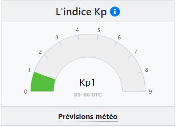
The strength of the Orpheon network
Our network is currently built according to the rules of the art with stations every 60 km, you should not normally be too affected. However, we wanted to pass on the information to you, an informed user is worth two!The geometric regularity of our layouts
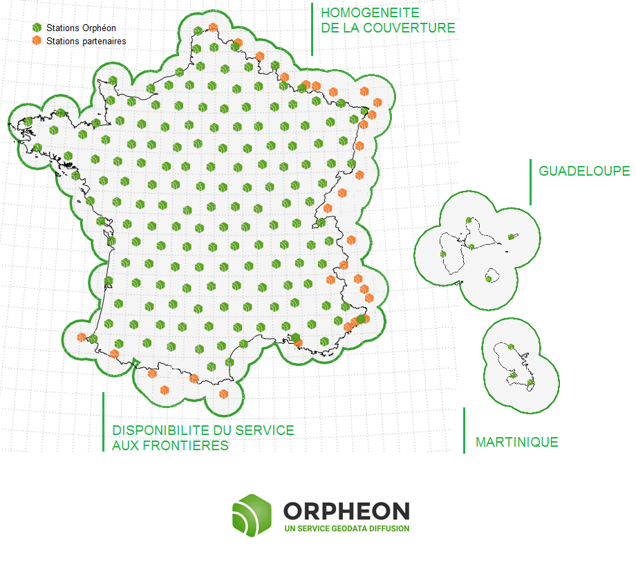
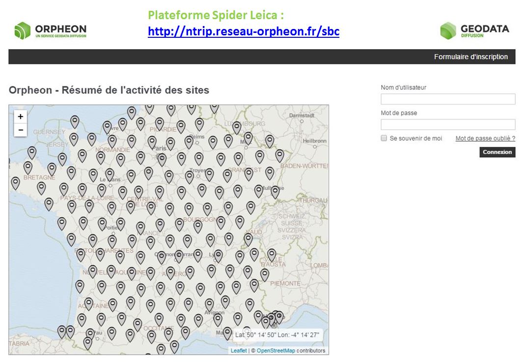
The Orphéon network has 215 stations in mainland France, all Full GNSS, i.e.: GPS, GLONASS, Galileo and BeiDou, as well as a historical presence in the French West Indies. The dense network of permanent stations is arranged regularly every 60 km. Each link in the Orphéon infrastructure has been designed to offer a high-precision RTK correction service available in all circumstances. Border areas are complemented by our partnership agreements within Europe.Click on the interactive map of the Orphéon network
-
A very regular presence, without compromise and without equivalent in France.
- The careful choice of layout for each of our 195 reference stations creates a linear and regular geometric mesh. Territory coverage is uniform wherever you are. With the Orphéon network, you work with identical precision throughout the territory thanks to a uniform distribution of stations over all the areas covered, whatever your position, the distance from the nearest reference station is never more than 30 km. The Orphéon network thus stands out significantly from its competitors who are multiplying the number of reference stations because of their disorderly location on the territory and whose coverage is losing homogeneity, sometimes leaving very large distances in the meshes of their network.
A regular and homogeneous layout
Constellations already operational today :
05/11/2017For GALILEO,
There are currently between 4 and 5 functional satellites which are permanently available for your positioning and the FULL GNSS corrections of the network.

The only Galileo corrections already available in France
Of course, the European system, which today has 16 satellites in orbit, will continue to develop and expand with the forthcoming launch of 4 new satellites, but their number already makes it possible to make a difference and to work in better conditions.
For BeiDou,
There are also between 1 and 4 satellites permanently available for your positioning and the FULL GNSS corrections of the network.
Multi-frequency L1/L2 and L5
Based on L1 and L5 frequencies emitted by satellites to make positioning more resistant to interference and signal reflections, especially in an urban environment. Everything has been thought out to allow you to benefit from increased productivity.- Centimeter accuracy corrections for GPS GNSS
- Use of L1/L2 and L5 frequencies
- Real time, very fast convergence time
- A dense and homogeneous RTK network
- A regular and geometric implantation on the whole territory
- An infrastructure designed for service performance
- Very secure facilities
- National and West Indies coverage
- A reference for professionals
- Accuracy, Stability, Availability, Repeatability
- Increasingly varied applications
For you, in the field 6 additional satellites,
Sur le terrain, vous pouvez donc compter en permanence sur une disponibilité constante d’au moins 6 satellites supplémentaires.
Le cumule de ces 2 constellations supplémentaires font aujourd’hui une réelle différence pour votre productivité.Il n’est donc pas besoin d’attendre 2020 pour tirer le meilleur partie de vos équipements Full GNSS.
Profitez dès à présent des corrections FULL GNSS disponibles sur la totalité du territoire et aux Antilles françaises.How to take advantage of the new Full GNSS services?
Already subscribed? Connect today to our real-time services from your GNSS-compatible mobile with your usual user connection parameters (username and password) and select one of our Full GNSS mount points stamped “FULL”.Settings :
- DNS: ntrip.reseau-orpheon.fr
- Port: 8500
- Mount point*: VRS_RTCM-MSM_FULL or i-Max_RTCM-MSM_FULL
Contact our Technical Service who will bring you concrete help and guide you step by step.
As a reminder, in order to be able to position itself within a few centimeters, a GPS/GNSS rover must be able to:
- perform noise-free phase measurements on at least 5 satellites well distributed in space,
- and receive differential corrections on these same 5 satellites.
How does it benefit you on a daily basis?
100% more satellites
The addition of the Galileo and BeiDou satellites to the GPS and GLONASS satellites significantly increases the number of satellites that can be observed simultaneously by a GNSS antenna. The addition of the GALILEO and BeiDou constellations thanks to the Orphéon network is not a simple gadget, but the assurance of better daily productivity in the field. Indeed, you can now permanently count on the constant availability of at least 6 additional satellites to bring you real advantages:Improved positioning quality
- More satellites available to calculate its position
- Precise positioning even in difficult environments (urban canyons for example or under a canopy)
- Improved positioning reliability
- Shorter fixing time
The densest and most regular coverage area in France
A multi-constellation network
With its 215 stations in mainland France, all Full GNSS: GPS, GLONASS, Galileo and BeiDou with a unique presence in the French West Indies.
Orphéon is the first French multi-constellation network in France.
Learn more: : See the page : Work in difficult places Contact our Technical Service who will bring you concrete help and guide you step by step.
For the same price
GPS+Glonass subscriptions have become Full GNSS!
You now benefit, without a price increase, from an unlimited GPS + GLONASS + Galileo + BeiDou subscription in addition to our new online Post-Processing & RINEX Download services, whether your subscription is: Local, Departmental, Regional or National. With your Orpheon subscription, you therefore have access to:- An unlimited Full GNSS real-time centimetric correction service
- An online RINEX Full GNSS Post-Processing service
- An online service for downloading RINEX Full GNSS
- A web platform providing access to your account, your subscriptions and the state of the Orphéon network
- A Smartphone application offering the same functions as the Web platform
How to take advantage of the new Full GNSS services?
Connect today to our real-time services from your GNSS-compatible mobile with your usual user connection parameters (username and password) and select one of our Full GNSS mount points stamped “FULL”.Settings :
- DNS: ntrip.reseau-orpheon.fr
- Port: 8500
- Mount point*: VRS_RTCM-MSM_FULL or i-Max_RTCM-MSM_FULL
30% Discount to upgrade your hourly Package to a subscription
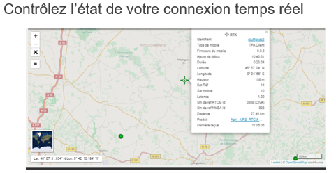
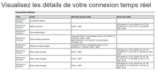
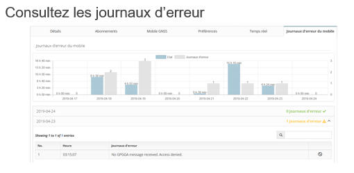
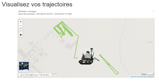
You have subscribed to a real-time hourly package, benefit from a discount of up to 30% of the value of your current package for any subscription to an unlimited subscription and benefit from the RINEX Post-processing & Downloading web application in plus Full GNSS real-time corrections as described above. Depending on your specialty, contact your usual distributor without hesitation (Find your Orpheon distributor), he will know, better than anyone, how to answer you and support you in your projects.From our Spider platform, it is possible to connect to your customer account with your identifiers to view for each of your connections:
- detailed logs
- Path

Go straight to the point!
Depending on your work environment and the usual platform on which your GPS is connected. This dedicated platform offers all our customers various services that complete access to your real-time GNSS corrections. It also allows you to freely consult:
-
-
-
- The status of the Orpheon GNSS network
- Your personal information
- The contracts you have entered into
- Your connection history
- The history of your e-Invoices*
- The remaining credit on your hourly rate
-
-
History of your e-invoices:
*Available, if you are billed by Geodata Diffusion directly for your subscriptions or your packages and you have accepted the dematerialized billing method (for more details see the dedicated e-invoice page). Easily find the history of your invoices on your customer area : https://fr.nrtk.eu/SBC/ Log in to your space with your username and password.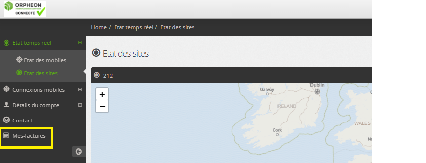
 Retrouvez vos informations de connexion et connectez-vous à l’aide de votre identifiant et de votre mot de passe, sur l’une des plateformes suivantes :
- Plateforme Spider Leica : http://ntrip.reseau-orpheon.fr/sbc
 With your smartphone
To access this information wherever you are, connect by flashing the QR-code below corresponding to the dedicated platform on which your GPS is usually connected:
Leica Spider platform:

- Status of your Mobile
- Real-time network status
- Check your NTRIP connection
- Your personal information
- Your contracts
- Contact us
- Settings
From today, find the Orpheon application
For downloading the Orpheon application
Directly on the Apple Store or on Google Play:
Click on the image below to access more information about our Smartphone applications and its features.
Flash the QR code with your Smartphone to access the download page of the Apple Store or Google Play. Once the application is downloaded, you can benefit from additional information which will follow you everywhere in the field.


Using the Orpheon app
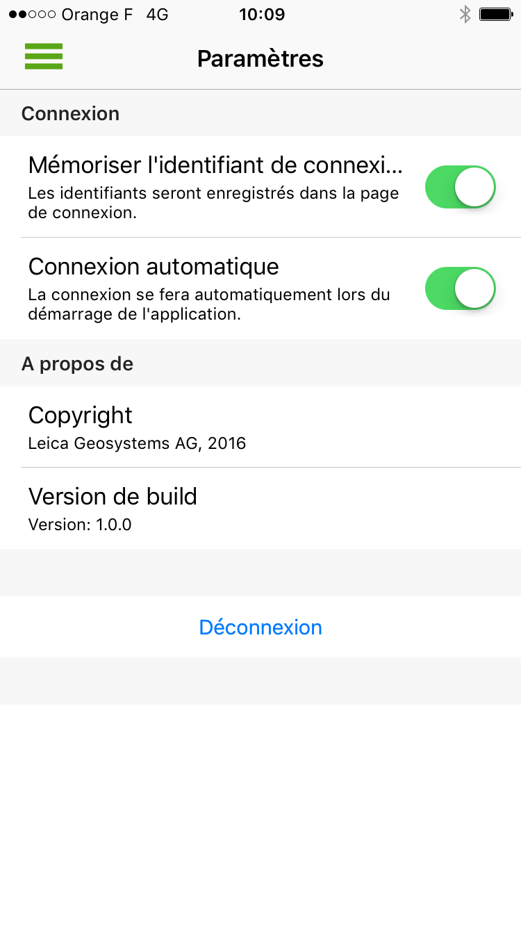
Simple Connection
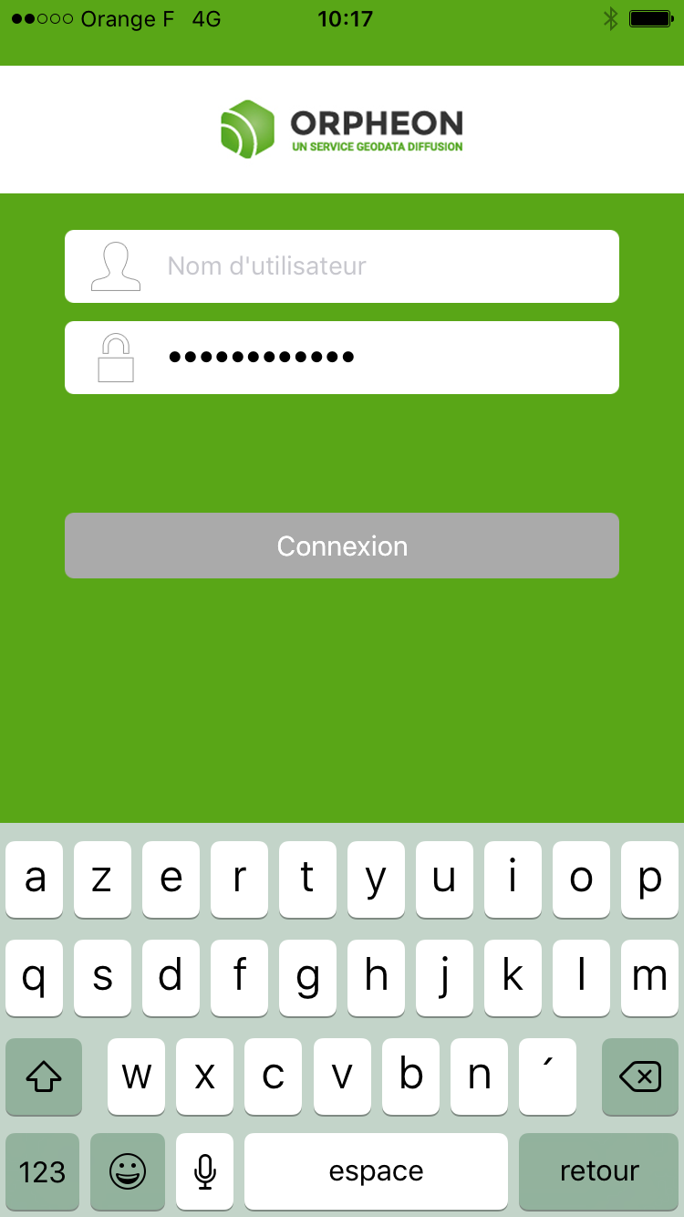 Using your username and password you can log in to the application.
The different menus
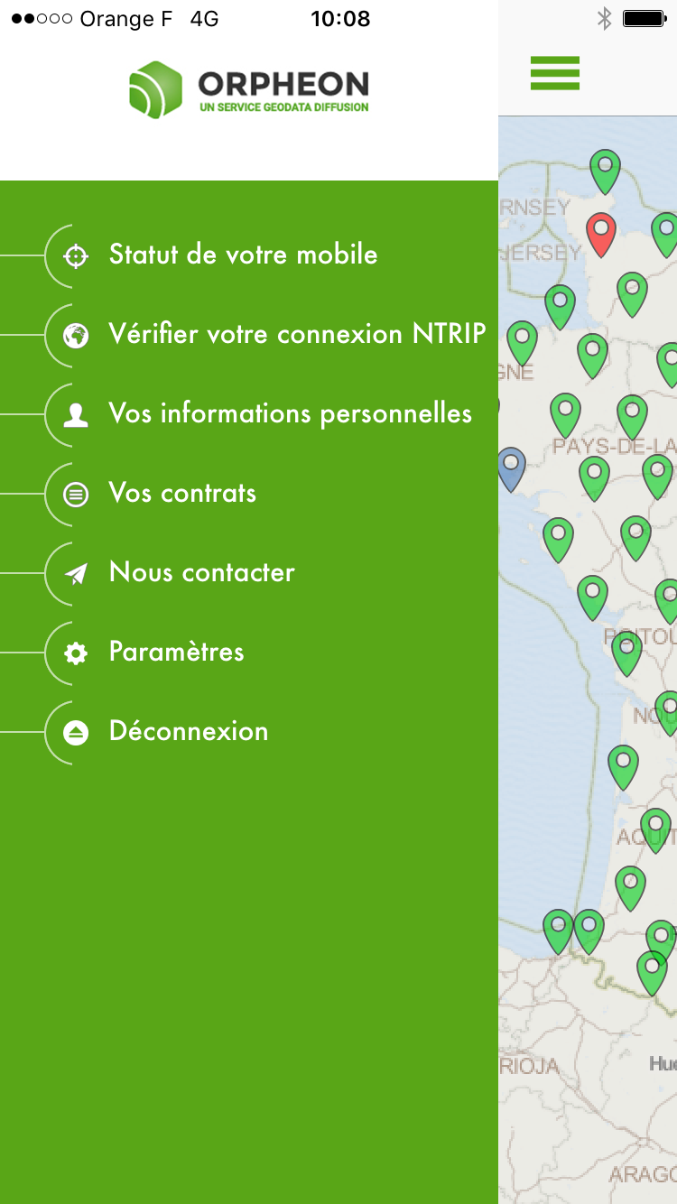
Status of your mobile
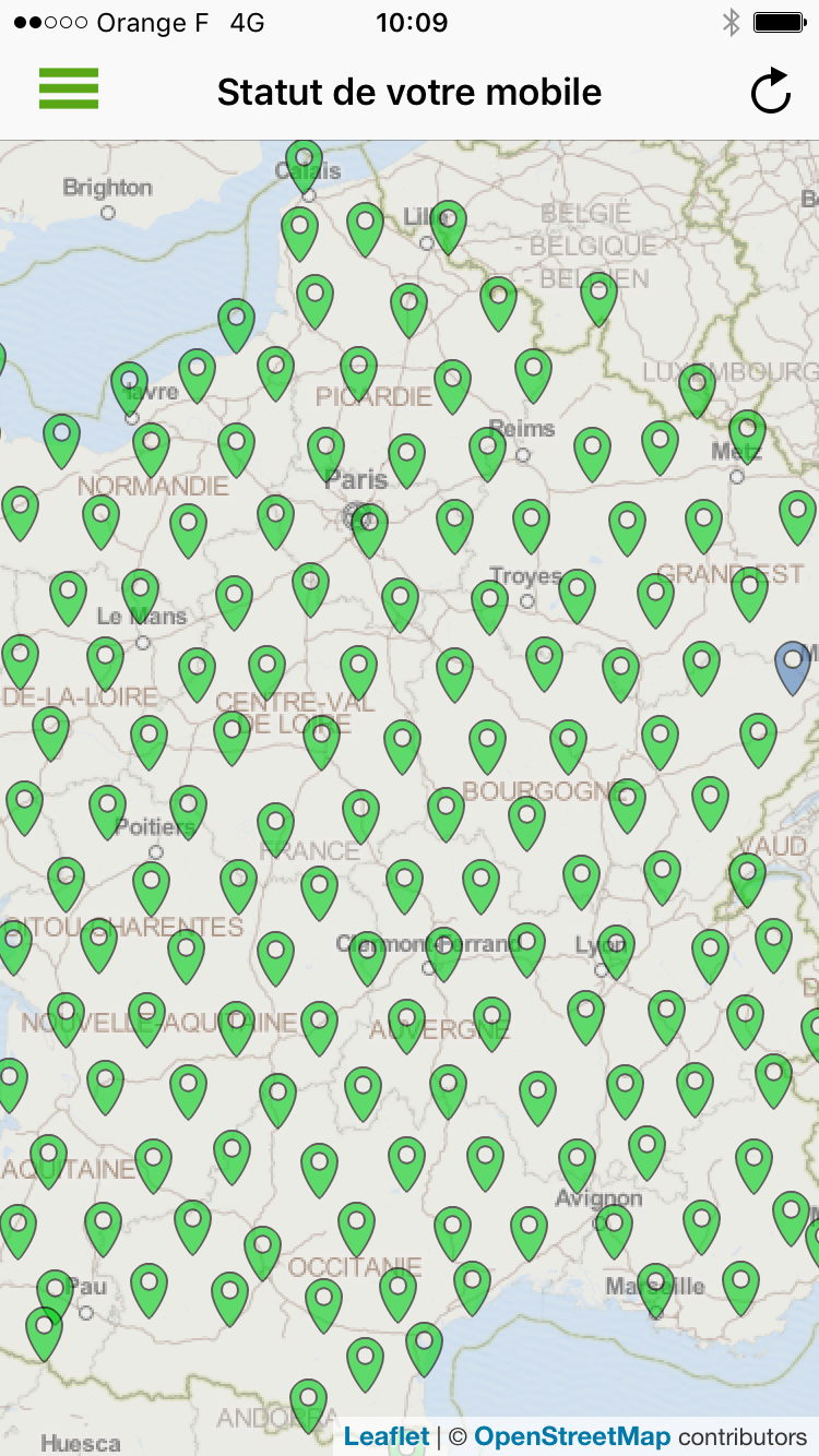 With a simple glance, check the status of your mobile and its connection, but also you can consult the status of the entire network.
Check your NTRIP connection
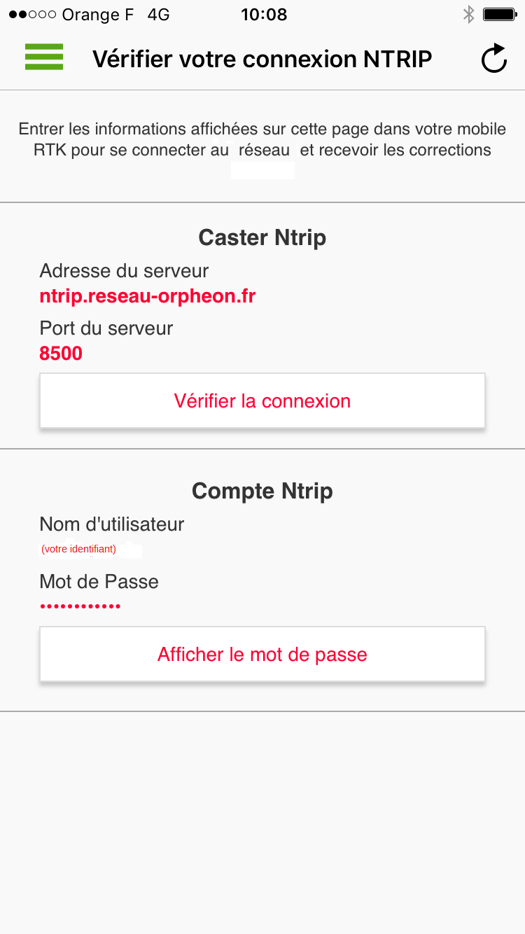 Connection information directly accessible for the configuration of your mobile
Your personal information
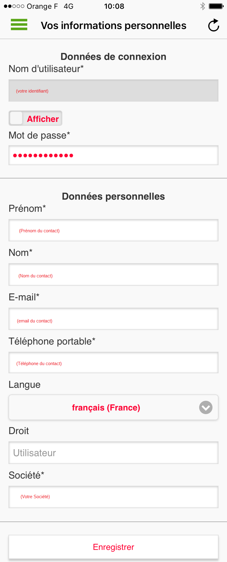 You can view the contact information associated with the account used.
This information complies with our privacy policy.
You can view the contact information associated with the account used.
This information complies with our privacy policy.
Your contracts
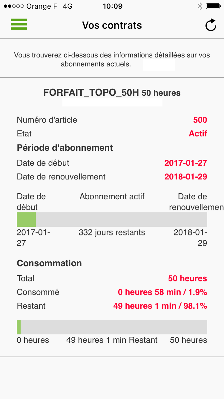 You can consult the information associated with all the contracts linked to your account. You can thus control the consumption of your plan or the remaining time.
Contact us
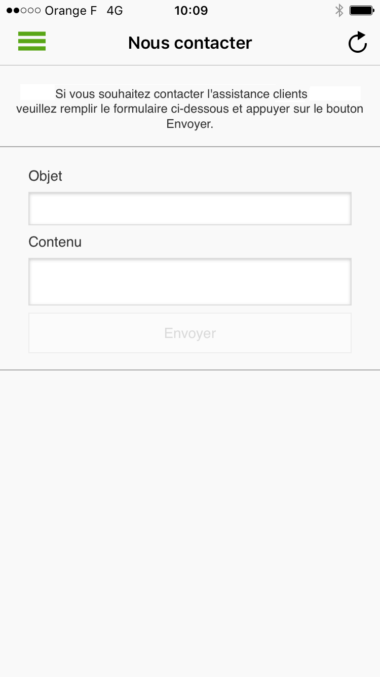 You can message us directly
Configuration setting
 Application configuration settings on your smartphone
For the same price
GPS+Glonass subscriptions have become Full GNSS!
You now benefit, without a price increase, from an unlimited GPS + GLONASS + Galileo + BeiDou subscription in addition to our new online Post-Processing & RINEX Download services, whether your subscription is: Local, Departmental, Regional or National. With your Orpheon subscription, you therefore have access to:- An unlimited Full GNSS real-time centimetric correction service
- An online RINEX Full GNSS Post-Processing service
- An online service for downloading RINEX Full GNSS
- A web platform providing access to your account, your subscriptions and the state of the Orphéon network
- A Smartphone application offering the same functions as the Web platform
How to take advantage of the new Full GNSS services?
Connect today to our real-time services from your GNSS-compatible mobile with your usual user connection parameters (username and password) and select one of our Full GNSS mount points stamped “FULL”.Settings :
- DNS: ntrip.reseau-orpheon.fr
- Port: 8500
- Mount point*: VRS_RTCM-MSM_FULL or i-Max_RTCM-MSM_FULL
30% Discount to upgrade your hourly Package to a subscription
You have subscribed to a real-time hourly package, benefit from a discount of up to 30% of the value of your current package for any subscription to an unlimited subscription and benefit from the RINEX Post-processing & Downloading web application in plus Full GNSS real-time corrections as described above. Depending on your specialty, contact your usual distributor without hesitation (Find your Orpheon distributor), he will know, better than anyone, how to answer you and support you in your projects.Learn more : See page : Choice of SIM cards Discover the offers
Learn more : Discover the offers New: Géodata Diffusion now offers you a new Local work area* suitable for long-term construction sites or sedentary users . More information ….
- perform noise-free phase measurements on at least 5 satellites well distributed in space,
- and receive differential corrections on these same 5 satellites.
See the page : Work in difficult places Contact our Technical Service who will bring you concrete help and guide you step by step.
- Voir la page des systèmes GPS / GNSS de Leica Geosystems.
- Voir la page des récepteurs GNSS de TopCon.
- Voir la page des systèmes GPS / GNSS de Trimble (site en anglais).
- Voir la page des systèmes GPS / GNSS de Spectra précision (site en anglais).
- Voir la page topographie / Géodésie d’Ashtech (site en anglais).
- Voir la page produits de Geomax (site en anglais)
Learn more : Contact our Technical Service who will bring you concrete help and guide you step by step.


