
 Orphéon is a real-time RTK Full GNSS precision augmentation GPS correction system allowing users to position themselves with centimeter precision in the national reference anywhere in France and the West Indies with a single GNSS receiver:
 Provide RTK GPS corrections
The Orphéon network is made up of nearly 220 observation stations, spread over the entire territory of metropolitan France and the West Indies. All of our stations form a large balanced RTK network that allows us to deliver centimeter RTK corrections to our many customers to increase the accuracy of their precision GPS. Our various services are marketed in the form of subscriptions or hourly packages.Accuracy and availability
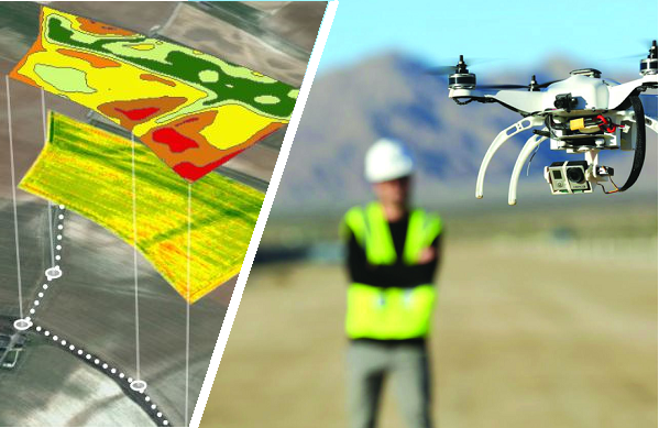
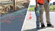
Thanks to its precision and the availability of its RTK GPS corrections, the Orpheon network offers increased productivity to all of its users in the fields of topography, construction, 3D digitization, machine control, precision agriculture and bathymetry, but also for new applications concerning autonomous vehicles, drones (UAV) and connected objects (IOT and M2M). Géodata Diffusion continues to develop the quality of its services through personalized support, responsive technical assistance and continuous improvement of its infrastructures. Our objective is to offer customers a secure and innovative service, guaranteeing them a high and constant utilization rate wherever they are, throughout the territory.GPS Accuracy
The natural position provided by a GPS alone, gives a good idea of where it is within a few meters, but is not precise enough to allow precision work. It requires correction so that its precision is increased and usable in agricultural work, topography, machine guidance or in many other fields of application (see).
For your Trajectography work
In dynamic measurement operations, the integration of GPS RTK, LiDAR, and the latest generation inertial units combined with GNSS corrections generated via the Orpheon network allow both:
- rapid implementation and simplified deployment,
while guaranteeing an optimum level of precision
they eliminate the need for a second GNSS receiver (base) - considerably reduce or even eliminate the implementation of checkpoints depending on the applications.
- rapid implementation and simplified deployment,
These corrections, provided in real time or in post-processing via the RINEX files of our permanent stations, also make it possible to facilitate and significantly reduce the processing of data or images.
Downloading RINEX Files for Post Processing
Geodata offers, via an Internet connection to access a Web interface, the downloading of RINEX files necessary to improve its positioning by differential methods in deferred time (post processing).
Depending on the type of measurements carried out, fixed or mobile, several post-processing solutions can then be envisaged with respect to a physical permanent station or else with respect to a virtual station created from several physical stations.
compared to physical permanent stations
- PPK method: Kenematic post processing for mobile rover
- PPS method: Post processing Static for fixed rover
relative to a virtual station
- N-PPK method: Network Post processing Kenematic for mobile rover
- N-PPK method: Network Post processing Kenematic for stationary rover
We offer an offer in the form of different Hourly Packages* adapted to your different needs. (*valid for 12 months from the date of subscription).
Do not hesitate to contact us for any additional information.
Orpheon Online Post-Processing Service
Your results in one click
Since January 1, 2019, we have expanded our service offering by offering all our users new simplified online services. Our online application now allows you to post-process your data with computed virtual stations, just like post-processing your data from data from physical stations in the Orpheon network, allowing:
- To post-process with data from Orpheon network stations your raw GNSS data recorded in the field in RINEX format, whether physical stations but now also with calculated virtual stations.
- Download raw GNSS data in RINEX format from the physical stations of the Orphéon network in order to carry out personalized post-processing.
- Constant centimetric precision Full GNSS, GPS + Glonass + Galileo + BeiDou
Navigation
Knowing its position, its course, its movements, are all essential data that you need to have when you are on the move. Precision is your greatest ally because it provides security for you and for your direct environment.
Everything has been thought out to allow you to benefit from increased security.
- Centimeter accuracy corrections for GPS
- Real time, very fast convergence time
- A dense and homogeneous RTK network
- A regular and geometric layout throughout the territory
- An infrastructure designed for service performance
- Very secure facilities
- National and West Indies coverage
- A reference for professionals
- Accuracy, Stability, Availability, Repeatability
- Increasingly varied applications
Technically:
The fact of working in a network makes it possible to obtain, in a few seconds, a homogeneous precision on all the covered zones, whatever the distance separating the mobile from the nearest station, on the whole territory. The system is compatible with the vast majority of mobile receivers on the market insofar as the corrections are broadcast in standard formats:
- In a standardized format (RTCM3) or in well-defined proprietary formats (CMR/CMR+, LB2)
- Following well-defined and standardized (MAC) network computing concepts.
The Orpheon infrastructure
With the idea of reducing latencies as much as possible and increasing the availability of our services, powerful machines used to calculate the NRTK correction are hosted in a Datacenter located at the heart of our telecommunications operator’s network, i.e. say as close as possible to its own machines.
- Infrastructure designed for service performance
- No loss of time between reference stations and servers
- Powerful computing servers
- Optimized data paths
- Lowest latency times
- Services always backed up with the same performance
Orpheon subscriptions
The Premium Orpheon offer These subscriptions give access to unlimited Real-Time correction services in the NRTK Full GNSS centimetric repeatable GPS + Glonass + Galileo + BeiDou network.Hourly Packages
The non-binding offer This is access to the N-RTK GNSS correction network with real-time centimeter accuracy (GPS, Glonass). Often used to discover our services.Online post-processing and RINEX files from the Orpheon network
The 3D control offer This is access to the N-RTK Full GNSS correction network with centimeter precision (GPS, Glonass, Galileo, Beidou). Often used to control the accuracy of its measurements or even for areas where a mobile internet connection is not available for real time.
Benefits
In your professional practice you can count on the knowledge, the know-how and the centimetric precision of the Orphéon network to meet your missions and your obligations.
The network has been thought out and designed according to the rules of the art, it is constantly monitored and checked regularly. (The network-Orpheon).
Everything has been thought out to allow you to benefit from increased productivity.
