Share the post "Precision Agriculture: Increasing Harvest Productivity"
Harvesting is a fundamental phase of farming during which it is also possible to increase efficiency and limit certain losses.
It is estimated that the losses in these productions can still reach up to 10% of the total yield of a plot. In addition to natural factors that are difficult to control, these losses are also linked to a lack of vigilance in agricultural production, such as inattentive regulation or poor machine operation.
Pay attention to the settings of agricultural machinery
Adjusting and maintaining consistency in machine forward speed with configurations suited to the crop, material density and production area is essential to avoid compromising the harvest and preserve production. Today, there are technologies that work in remote and centralized control of operations, allowing the monitoring of agricultural machinery settings in real time even from a distance. “This follow-up allows us to intervene quickly whenever necessary. In the case of the HxGN AgrOn control room, for example, the solution itself sends notifications and alerts of irregularities, incidents and machine performance issues to operators in real time. It is even possible to set the software to issue an alarm when a machine exceeds the stipulated speed”.Machine trajectory accuracy
Another action that can help preserve the productivity of mechanized harvesting is controlling traffic so that machines do not run over crop lines and compromise production. To optimize this control, it is important to invest in technologies that help guide machines to follow routes in the intended alignment, such as automatic steering. The use of an automated navigation system ensures precision for machines to pass exactly in the intended alignment, which avoids trampling on lines, reduces overlapping areas and reduces soil compaction.Synchronize agricultural machinery for more efficient harvesting
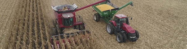
At harvest time, the automation of the machines makes it possible to avoid stoppages and delays in the operation, thus ensuring greater efficiency. Stopped harvesters mean lost productivity, which is why many on-board solutions aim to streamline the harvesting, loading and transport processes. Thus, certain applications from major manufacturers synchronize the movement of the transshipment tractor with the cutting rate of the harvesters, indicating the ideal moment of movement so that the downtime of the harvesters is reduced and the cutting is not interrupted. Thus, the operating time of a harvester can increase by up to 50% during the day.
Integration of centimetric precision GPS for guidance
All of these solutions offered by the various manufacturers or integrators embed a precision GPS and receive corrections to refine their position with greater precision. With the advancement of technologies like this, it is possible to use resources more and more intelligently on the ground, ensuring that benefits such as profit and sustainability are possible and contributing to the advancement of a new, even more efficient agro-industry.Accurate GPS and mobile internet connection
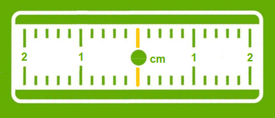
Many applications exist today precisely to locate these objects but do not have the precision necessary to take a real advantage. With ± 5m of precision, a classic GPS gives an idea of a position or a route, but when you want to guide a movement to avoid obstacles or you need to know in detail a trajectory, an exact position at an instant t, centimetric precision then becomes indispensable and vital. A precision GPS associated with corrections from the Orpheon network provide the desired centimetric precision.
Corrections to gain precision
For its accuracy to be increased and usable in agricultural work, surveying, machine guidance or many other application areas (see) It requires corrections.Precision GPS
We distinguish between two types of GNSS receivers:-
-
-
- Consumer receivers (Watches, phones, tablets, cars etc…) which will only work in natural mode without the possibility of improving their accuracy through corrections
- Precision receivers (RTK), which will be able to integrate external correction data from the Orpheon network allowing them to increase their precision.
-
-